Wednesday, January 13, 2010

The Haiti earthquake - likely shaking damage to structures

Over the last few years a number of studies have examined the level of damage associated with the intensity of shaking in earthquakes. The table below shows the relationship between shaking intensity (MMI) across the top and different types of building down the side. The number is the percentage of buildings damaged or collapsed:

Click on the table for a better view in a new window.

This is then helpful for examining the likely level of damage in Haiti, which can be estimated from the USGS shake map:

This should then be compared with the USGS data on the exposed population (MMI=7 and above only):

The USGS suggest that 137,000 people live in the MMI=X zone and a further 710 in the MMI=IX zone. Note that almost all of the news at the moment is from Port-au-Prince, which is in the MMI=VIII zone.

This GoogleEarth image shows some of the urban slums on the edge of Carrefour, in the MMI=IX zone, before the earthquake. As most of the buildings here are likely to be unreinforced masonry, the building collapse rate is probably 80% or more. This could be higher due to the effects of the slopes, which both increase the intensity of shaking and make the foundations less secure.

Initial reports of landslides induced by the Haiti earthquake

It is inevitable that the Haiti earthquake will have triggered landslides, especially in the mountains and in the slum areas built onto the hillsides around the large cities. At present it is not possible to quantify how large these impacts will have been, but some reports are starting to emerge:

The BBC live coverage has this report:
Emmet Murphy, Jacmel, Haiti, emails:I was driving through the mountains when the car started to shake. It was like a very strong wind was blowing and I nearly lost control of the car. Rocks started falling on the road. I continued driving slowly and I saw people in the road screaming. The mountain was collapsing and a building to one side had already fallen down. A huge dust plume raised from the valley floor. I drove further and found the road totally blocked by a massive landslide on the road. I just knew that if I had reached that spot five minutes earlier, I would have been killed. I had to abandon the car and continue on foot.
Meanwhile, this blog from Bermuda is reporting that: "Slum areas have also been badly hit by landslides."

As well as a rather peculiar earthquake prediction, HaitiXchange has this picture of the slums around Port-au-Prince, the capital city, before the earthquake, which graphically illustrates the likely problem in this area:


Meanwhile this extraordinary Youtube video shows the aftermath of the earthquake from a vantage point high above the city. Again, the height of the hills is an indication of the likely landslide problems, but the major point here is the dust pall across the city, thrown up by collapsing buildings:


Finally, as per my earlier post, the lack of news from areas outside Port-au-Prince is a very major worry. I am sure that the picture there is very serious indeed.

On a personal note, I am in New Zealand so cannot be contacted in my office. My mobile number is +44 7983 702717. It will be on for the next few days if you need to contact me.

Haiti - some thoughts on disaster reporting by the media

Watching the reports of the earthquake disaster in Haiti coming in, I thought it might be useful to share some observations on the reporting of the immediate aftermath of disasters in less developed countries:
1. Everything stops at night. At the time of writing it is still night time on Haiti. In the aftermath of an earthquake electricity and power supplies are wiped out, so for the night time period it appears that the disaster is not as bad as is feared. As the sun comes up so the reports on the true picture start to emerge, and the fatality statistics start to increase rapidly. This increase will continue for several days at least, but may ultimately exceed the final toll;
2. The initial focus is often wrong. In the immediate aftermath of a disaster the initial focus of the media reports is often on the biggest city. This is rarely where the biggest impact has occurred, but it is most accessible so will be the focus of the reports.
3. No news is very, very bad news. The biggest impacts are often in rural areas with the highest levels of shaking. These areas had poor communications to start with, but when an earthquake strikes the roads become blocked, power is lost and there is no telephone service. Therefore, no news comes out for some time after the quake. The picture is actually the opposite of the obvious. If news starts to emerge quickly from those areas with the highest shaking then the picture is not as bad as we feared - at least some communications are open - although it may still be quite grim. If there is almost no news at all from the rural areas for a day or two, then the picture is probably very bad indeed, with almost all of the communications wiped out.
4. The media focus will quickly change to the foreign rescue teams. However, although these efforts are valuable, their overall impact is very small. The real work is actually done by local people - most rescues are made by untrained people in the first 24 hours - this should really be the focus.

At the time of writing the reports seem to be focused on Port-au-Prince, with nothing from the areas to the southwest that have been worse affected. This is not a good sign.

Tuesday, January 12, 2010

The likely impacts of the Haiti earthquake

The earthquake in Haiti is likely to have caused very high levels of damage and many fatalities. The USGS is currently reporting the earthquake as magnitude 7.0 at a shallow depth (only 10 km), which will have led to high ground accelerations for a large area of the country:
The USGS PAGER analysis, which examines the vulnerability of the population is the affected area places three large communities (Petit Goave, population = 15,000; Leogane, 12,000; and Grand Goave, 5,000) in the intensity (MMI) = X area and one community (Gressier, 4,000) in the MMI=IX zone. Very worrying in the city of Carrefour (population = 442,000 people) in the MMI=VIII zone and both Port au Prince (population =1.235 million) and Delmas (population = 383,000 people) in the MMI=VII zone.

A reminder of the levels of damage associated with the higher intensities is as follows:

MMI=VIII. Damage slight in specially designed structures; considerable in ordinary substantial buildings with partial collapse; great in poorly built structures. Panel walls thrown out of frame structures. Fall of chimneys, factory stacks, columns, walls and monuments. Heavy furniture overturned. Sand and mud ejected in small quantities. Changes in well water. Persons driving cars disturbed.

MMI=IX. Damage considerable in specially designed structures; well-designed frame structures thrown out of plumb; great in substantial buildings with partial collapse. Buildings shifted off foundations. Ground cracked conspicuously. Underground pipes broken.

MMI=X. Some well-built wooden structures destroyed; most masonry and frame structures destroyed with foundations; ground badly cracked. Rails bent. Landslides considerable from river banks and steep slopes. Shifted sand and mud. Water splashed, slopped over banks.

Needless to say Haiti's building stock is in general not designed to withstand seismic events.

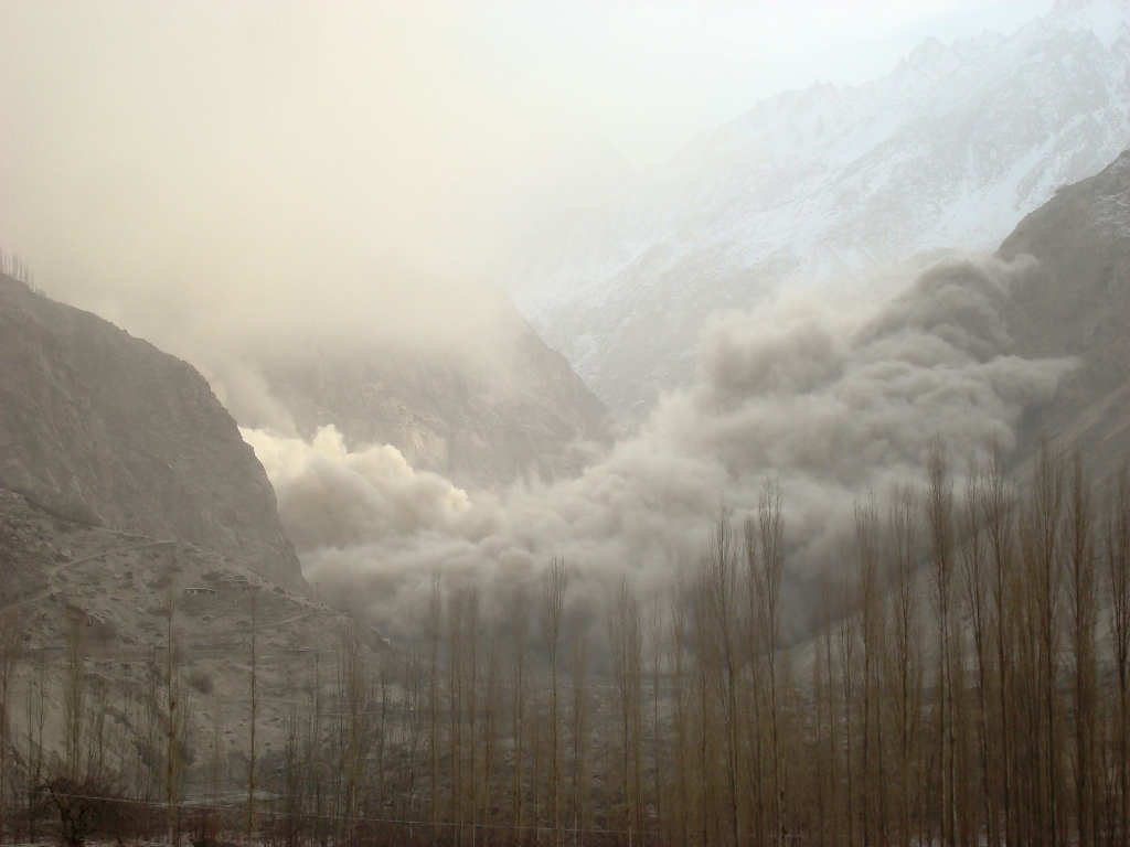
Unfortunately, Haiti has long featured large in the fatal landslide catalogue. The major issue, as I highlighted in this post from September 2008, is that the hillsides have been stripped bare for firewood, and so are very vulnerable to landslides. Thousands have been killed in mudslides, especially around the city of Gonaives, in the last decade. As the Google Earth image below shows, the area affected by the earthquake is mountainous:


It seems likely that landslides will represent a major problem in the rural areas. The news that emerges from Haiti over the next few days is likely to be very grim indeed. The combination of a large earthquake at a shallow depth very close to major population centres in an essentially failed state that is the poorest country in the western hemisphere is likely to have induced a truly fearsome outcome.

Monday, January 11, 2010

Update on the Attabad landslide


Image from Pamir Times.

The Pakistan Red Crescent have published the latest update on the state of the Attabad landslide in northern Pakistan. The key information is that the water level in the barrier lake is rising at 0.4 feet (about 12 cm) per hour (NB note correction). The level is reportedly 44 feet (13.4 metres) from the crest of the dam. The lake is about to inundate the settlement of Ayinabad. APP reports that a channel will be constructed to drain the lake but that in the meantime downstream settlements are being evacuated.


Image from Pamir Times.

Meanwhile, clearance of the Karakoram Highway continues but is expected to take a month.

It remains difficult to determine the death toll from this event. The PRC report says "At least 15 people are reported to have been killed out of which and others are still missing". APP reports 13 deaths and six people missing.

Saturday, January 9, 2010

Riverbank collapses on the Murray River in Australia

As I am currently in Sydney en route to New Zealand it seemed appropriate to post an Australian story. Australia rarely appears on the fatal landslide database, but it currently has a profound slope failure issue of its own, which is sufficiently serious to merit a campaign by a newspaper.

The issue is related to the Murray River in the southeast of the country:

The problem is that the Murray River is currently suffering river bank collapses along a 270 km stretch. The land adjacent to the banks is cracking, some collapses have already occurred, and the situation is getting progressively worse.

Image of an ongoing riverbank failure on the Murray (from here)

The problem is being blamed on the current drought in south Australia. As a result the flow level in the Murray River is at historically low levels. It is not immediately clear to me whether this means that the riverbanks have been debutressed by the reduced flow, or are cracking due to being exceptionally dry, or have lost the stabilising affect of vegetation due to the drought, or a combination of all three (or even some other factor), but the situation is clearly critical.

Detailed information and amazing images of the catastrophic Attabad (Atabad or Atta Abad) landslide in Hunza, Pakistan

See update from 11th January 2010 here


Pamir Times image of the landslide

A few days I ago I posted on reports of the Attabad landslide (which is variously described as the Atabad landslide or the Atta Abad landslide) in Hunza, Pakistan. There has been very little information about this bar various reports that it was not as bad as had been feared. However, Reliefweb has today published a report from the Pakistan Red Crescent that paints a rather different picture.

The essence of the report is as follows:
  • The slide occurred in two parts, the first at 13:00 (local time) on Monday 4th January, the second two hours later. The second slide was the larger of the two;
  • To date 15 fatalities have been recorded; an unknown number of people are missing;
  • Debris has covered a 4 km stretch of the Karakoram Highway, to a maximum height of 263 feet (80 metres) (!!!). The road is still closed;
  • 1763 people have been displaced.
However, perhaps the most important part of the report states that:

"On 6th January Pakistan Red Crescent Society (PRCS) Gilgit-Baltistan branch reported that the Hunza River is still blocked and its level
had risen to 350 feet and still rising. The situation raises fears that low-lying areas across the
river would be inundated. The population of these red-zone areas is estimated to be around
20,000 people."

350 feet = 107 metres.

The Pamir Times has published a very high quality set of images of the landslide here. Two images are particularly useful - first, this one shows on an aerial image the area affected by the landslide:


Second, this image shows the slide debris and the lake, taken I assume from the top of the landslide debris pile:

The most extraordinary image though is this one, captioned "Huge clouds of dust arise as land sliding continued on second day of the Attabad disaster":

Dawn.com reports that towns up the valley from the blockage, especially Gojal, are facing real hardship due shortages of food and medicine caused by the road blockage. This is of course mid-winter in a high mountain location. They suggest that it may take a month to reopen the road. Meanwhile they also expressed concerns about the potential for failure of the dam, causing a catastrophe downstream, which judging by the images above must be a real concern.

Finally, an EEFIT report on the landslide site, dated 2003, is available online here:

http://www.istructe.org/EEFIT/files/Atabad%20Landslide.pdf

The report describes the existence of a very large tension crack, in places 1.5 metres wide, across the slope and through the village. This crack appeared in 2003.

The reports states, with an impressive level of prescience:

A sudden catastrophic failure of the size, and which not uncommon elsewhere in the Northern Areas, could have the following effects:
• Removal of fields over perhaps half the village area and also removing nearly 30% of the
farming properties.
• Destruction of the rough mountain road probably with no alternative route that could be
established at any time in the near future.
• A blockage of the Hunza River - of a temporary or permanent form. Dam breakage could
cause disastrous water wave effects down stream. The dam hypothesis should be compared
with the estimated 2Mm³ of scree soil that in 1980 formed a permanent dam across the
Ghizar River just up stream of Gupis, west of Gilgit.
• Creation of an adjacent unstable landform and which contains other houses and associated
fields.
• Knock-on effects of loss of tree stands in minor descending lateral Hunza Valley gorges.
• Destruction of buildings, farmed lands and water supply to Sarat village.


Comments and thoughts welcome. See update from 11th January 2010 here