Tomorrow (Friday) I am giving a talk at Hazards Day in Manchester for AS/A2 students (year 12 and Year 13 in the UK system). The topic is the hazards associated with the Wenchuan (Sichuan) Earthquake in China. I have uploaded the file below:
Uploaded on authorSTREAM by Dr_Dave
This talk will be repeated at an event in London on Thursday 4th December.
Thursday, November 27, 2008
Wednesday, November 26, 2008
Extraordinary landslide video
In addition to the two landslide videos from Brazil, I have now come across an even more extraordinary video. This is apparently of a landslide that occurred in Mesitas in Colombia. Whilst the footage of the landslide itself is not as good as some others, the power of the slide as it hits a house is starkly illustrated. Unfortunately I cannot embed this one, so you will need to click the link below:
National Geographic Landslide Video
Absolutely incredible!
National Geographic Landslide Video
Absolutely incredible!
Brazil landslide disaster videos
Unfortunately Santa Catarina Province in Brazil is currently being affected by dreadful landslides and floods associated with a period of exceptionally heavy rainfall. The death toll is rising rapidly.
Incredibly, Brazilian news agencies appear to have caught at least two landslides in action. They can both be seen in the following Youtube video:
The first occurs right at the start of the clip. Unfortunately the film does not cover all of the slide, just the first few seconds. This is better caught on a video that I cannot embed, but which is at the start of the clip that can be found here. The second occurs at about the 16th second of the embedded video. I hope that better resolution film will appear in due course - please let me know if you come across it.
Meanwhile, a few images are appearing of the landslide damage, such as this:

UPDATE: I have now found a Youtube version of the first of the landslides above. Hopefully it will play below:
Tuesday, November 25, 2008
World Landslide Forum Report
Readers will probably be aware that last week the First World Landslide Forum was held at the United Nations University in Tokyo. This was apparently "a global cooperation platform for all types of organizations from academia, United Nations, governments, private sectors, and individuals which are willing to contribute for landslide and other related earth system risk reduction."
Unfortunately I wasn't able to attend, but two of my colleagues (Nick Rosser and Mike Lim) were there and have kindly written the following conference report. Thanks very much to them for doing this.

Unfortunately I wasn't able to attend, but two of my colleagues (Nick Rosser and Mike Lim) were there and have kindly written the following conference report. Thanks very much to them for doing this.

The First World Landslide Forum was held last week at the United Nations University, Tokyo, Japan. The initiative for this meeting has been driven by the International Programme on Landslides (IPL) under the remit of strengthening research and learning on Earth system risk analysis and sustainable disaster management. The meeting was attended by 450 delegates from 49 countries. Although attracting participants from beyond the normal geo-science conference circuit, there were also notable absences.
Continuing the focus on management issues raised in the preceding Sendai satellite conference, the need to marry scientific knowledge with practical site-specific implementation was stressed in opening addresses by representatives of the many organisations officiating. Konrad Osterwalder gave an eloquent address on behalf of the host United Nations University. He suggested that the crippling costs of landslides, driven by a lack of preparedness, can only be mitigated through a concerted effort towards resilience where the connectivity between the human and natural environments is fully appreciated; a theme which the following sessions attempted to follow. The welcome was concluded with a short play recounting the experiences a group of children who survived the 2006 Leyte landslide disaster. The play was a poignant reminder of the human cost of landslide disasters. Although not as punctual as the Shinkansen, the five parallel sessions of papers covered a range of topics from landslide mapping and early warning to social impacts and interesting country case studies, most with time for discussion.
Amongst the highlights were some interesting contributions from Jon Godt (USGS), Ken Hewitt (Canada), Janus Wasowski (Italy), Masahiro Chigira (Japan), and Sandre Catane (Phillipines). Jon Godt presented recent developments of the USGS near-real-time earthquake induced landslide prediction models, developed upon the PAGER platform. Based on the 1994 Mw=6.7 Northridge earthquake in California, the model uses a combination of modelled peak ground acceleration from tele-seismic monitoring combined with SRTM derived topography, coarse resolution geological mapping and material properties to predict the potential locations of failures. Jon presented an application of the technique to the 2008 Wenchuan earthquake, showing that the results demonstrated a basic similarity with the initial post-earthquake mapping, which was later presented in several papers in this session. Of these the presentation by Masahiro Chigira gave a comprehensive overview with landslide locations mapped primarily from ALOS PRISM data. Professor Chigira demonstrated the concentration of the failures along the fault rupture, with a tendency of failures to follow both topographic ridges, in addition to appearing to follow the main river valleys. A tendency for landslides to be oriented NW – SW was highlighted, most probably reflecting the fault controlled topographic alignment, in addition to some interesting observations of ruptures on calcium carbonate surfaces.
The all encompassing ‘catastrophic slides and avalanches’ session began with an engaging presentation from Professor Ken Hewitt, on his work identifying massive rock avalanches in the Nanga Parbat-Haramosh massif in Northern Pakistan. Ken gave a compelling overview of the changing interpretation of Himalaya landforms, suggesting that the frequency of large rockslides may actually be significantly greater than we believe. Without adequate dating of these now numerous identified failures, their temporal spacing and frequency remains a mystery, but they may hold significant information on mountain chain evolution given their impact and persistence. This is clearly an important subject for further research.
The ‘view from space’ session saw a range of papers, many applying the PSInSAR technique for landslide monitoring. Of note was a critical overview by Janus Wasowski of some of the challenges that remain when applying this technique. Janus demonstrated the apparent mismatch of displacement measurement identified by ascending and descending orbit imagery over a relatively short distance, and noted the problem of scatterer distribution across the area of interest. The other presenters on this subject gave impressive results, though questions remain with regards the ability to compare these results to more conventional techniques and to extract true landslide movement data. A need for presentation of the assumptions and the limitations of the technique alongside the impressive levels of precision is clear. A second predictably impressive paper in this session was given by Fausto Guzzetti, in which he presented the MORFEO project. Here a range of remote sensing imagery is employed to automatically derive landslide susceptibility maps. This work builds upon previous research to use data such as ASTER to characterise the spectral response of landslide scars at the regional scale. Again a promising area for future research.
In the country case studies session, Sandra Catane presented an extremely balanced appraisal of the current progress in landslide risk-reduction in the Philippines. She recounted the increasing awareness of land instability resulting from both climate change and population pressures and highlighted the problems faced by authorities in preventing settlements developing on hazardous areas. A conscious shift has been made by the government away from reactive damage limitation to proactive mitigation measures with the generation of a national coverage of 1:50,000 landslide susceptibility maps. Despite the progress made from the National Geohazards Mapping Program the Leyte and Albay landslide disasters of 2006 demonstrated the need to further improve the hazard management strategies. Sandra concluded by calling for a more formalised links between government agencies, industry and academia in order to develop more effective policies aimed at reducing risk from landslide hazards. The challenge of implementing national strategies successfully at the local scale was a recurrent theme throughout the conference.
The final day of the meeting focussed upon future directions. Overall a useful meeting that brought together a group of scientists and policy makers, with a perhaps notable absence of practitioners. Clearly evident was the disparity between the extreme and the everyday, and the esoteric versus the chronic landslide hazards that ultimately have the greatest cumulative impact. Many researchers are following parallel paths; let’s hope that meetings such as this enable these paths to cross. Clear issues remain including the motivation to study landslide risk (both hazard and vulnerability) in the everyday, and the appropriate transfer of both understanding and technology to those communities most impacted upon by landslides. We hope that the follow-up meeting in Rome 2011 will show progress in these areas.
Monday, November 24, 2008
Quarry rockfall in Guangxi
ChinaDaily is carrying the image below of an large rockfall in a former quarry in Fengshan County of Guangxi Province in China:

The accompanying report says that the landslide occurred without warning and without an obvious trigger in a long-abandoned quarry. The volume of the landslide is reported to be 21,000 cubic metres. It buried 300m of road, 16 buildings, two tractors, a car and a motorbike. Sadly, five people were killed, one person is reported missing and six people were injured, two seriously.
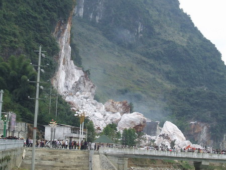
The accompanying report says that the landslide occurred without warning and without an obvious trigger in a long-abandoned quarry. The volume of the landslide is reported to be 21,000 cubic metres. It buried 300m of road, 16 buildings, two tractors, a car and a motorbike. Sadly, five people were killed, one person is reported missing and six people were injured, two seriously.
Thursday, November 20, 2008
Images of landslides from the Wenchuan Earthquake
(In response to requests, I have edited the post to provide some comments on the images)
I am in the middle of putting together a presentation on the impact of the Wenchuan Earthquake in China in May and thus have been looking for suitable materials. I stumbled across a fantastic Powerpoint presentation with images of the aftermath of the earthquake - this can be downloaded here.
There are a number of images of the landslides triggered by the earthquake in the presentation, but I thought would highlight three of them here:
 This image shows multiple shallow rock slides triggered by the earthquake. Note a few things here. First, a very large proportion (50%?) of the landscape has failed in this area. Second, the slides originate from very high on the slope - i.e. close to the ridge - and then extend all the way to the foot of the slope. This is characteristic of earthquake induced landslides and is associated with the high intensity of shaking that is experienced at the top of the slope. Finally, bite that piles of sediment at the toe of the slopes. This material will now move through the river system during periods of heavy rain and is likely to cause major problems downstream for years to come.

This picture shows a wider view of multiple shallow rock slope failures triggered by the earthquake. Most of the features pointed out above are again visible. The dust is caused by continuing landslide activity - probably in part due to aftershocks and in part with loosened material continuing to fail. The white area centre left appears to be zone of particularly shattered limestone. Note how the density of landslides reduces on the more gentle slopes in the background.
 This image shows the same features as above, but perhaps with the highest density of landslides. It does appear that there is a road or track at the bottom of the slope on the right. One can only imagine how difficult it will be to maintain these roads in the future.
Dave
I am in the middle of putting together a presentation on the impact of the Wenchuan Earthquake in China in May and thus have been looking for suitable materials. I stumbled across a fantastic Powerpoint presentation with images of the aftermath of the earthquake - this can be downloaded here.
There are a number of images of the landslides triggered by the earthquake in the presentation, but I thought would highlight three of them here:
 This image shows multiple shallow rock slides triggered by the earthquake. Note a few things here. First, a very large proportion (50%?) of the landscape has failed in this area. Second, the slides originate from very high on the slope - i.e. close to the ridge - and then extend all the way to the foot of the slope. This is characteristic of earthquake induced landslides and is associated with the high intensity of shaking that is experienced at the top of the slope. Finally, bite that piles of sediment at the toe of the slopes. This material will now move through the river system during periods of heavy rain and is likely to cause major problems downstream for years to come.
This picture shows a wider view of multiple shallow rock slope failures triggered by the earthquake. Most of the features pointed out above are again visible. The dust is caused by continuing landslide activity - probably in part due to aftershocks and in part with loosened material continuing to fail. The white area centre left appears to be zone of particularly shattered limestone. Note how the density of landslides reduces on the more gentle slopes in the background.
 This image shows the same features as above, but perhaps with the highest density of landslides. It does appear that there is a road or track at the bottom of the slope on the right. One can only imagine how difficult it will be to maintain these roads in the future.
Dave
Wednesday, November 19, 2008
Alesund landslide - the verdict
Back in April I posted extensively about a landslide that occurred in the town of Alesund in Norway. This slide occurred on 26th March, when a large block slipped into an apartment block, pushing it forward by up to seven metres and collapsing the lower floors. Five people were killed.

This week, the outcome of the commission of inquiry has been released. The key points are as follows:
 Presumably the blasting removed the toe of the block, destabilising it. If so then this looks to be an error of the site investigation and design. Given that the report has been handed over to Ministry of Justice, I would imagine that those involved in the original work will be somewhat uncomfortable now.

This week, the outcome of the commission of inquiry has been released. The key points are as follows:
- Blasting of the cliff during the construction of the apartment block was responsible for the failure;
- This blasting, which was intended to create the platform for the building, weakened the hillslope;
 Presumably the blasting removed the toe of the block, destabilising it. If so then this looks to be an error of the site investigation and design. Given that the report has been handed over to Ministry of Justice, I would imagine that those involved in the original work will be somewhat uncomfortable now.
Monday, November 17, 2008
Colombia landslide images
On Sunday a landslide occurred in the El Polbado neighborhood of the city of Medellin in Colombia. It is believed that 12 people were killed. ArabianBusiness.com has published the following images of the aftermath of the event:


It is clear that this happened in a fairly wealthy area of the town, unlike many landslides in S and C. America, which occur in the slums and garbage dumps. Steep slopes are so often occupied by the very poor (as they cannot afford land on the plains) and the very rich (who like the views and the cleaner air, plus maybe a sense of superiority.


It is clear that this happened in a fairly wealthy area of the town, unlike many landslides in S and C. America, which occur in the slums and garbage dumps. Steep slopes are so often occupied by the very poor (as they cannot afford land on the plains) and the very rich (who like the views and the cleaner air, plus maybe a sense of superiority.
Saturday, November 15, 2008
Article in the New Strait Times Malaysia
Shield your eyes from the photograph though...
People pressure on land has a telling effect
People pressure on land has a telling effect
Taipei workshop presentation
On 15th November I attended a workshop on land degradation and monitoring at the Department of Geography at National Taiwan University. This was to mark both the launch of a new Land Monitoring Centre and to celebrate the 80th anniversary of the founding of the university. Below is the presentation that I gave at that meeting:
Uploaded on authorSTREAM by Dr_Dave
As usual you can download the slide show by clicking on the Dr_Dave link above.
Comments welcome.
Uploaded on authorSTREAM by Dr_Dave
As usual you can download the slide show by clicking on the Dr_Dave link above.
Comments welcome.
Friday, November 14, 2008
October 2008 fatal landslide map
Rather later than is ideal (for which I apologise), here are the maps for fatal landslides in October 2008.
First, the statistics:
Number of recorded fatal landslides: 22
Number of recorded fatalities: 179
The average for the period 2002-2007 inclusive was 398 fatalities, excluding the impact of the Kashmir earthquake in 2005, so 2008 is considerably below the long term average.
This is the map of the fatal landslides that I recorded (click on the map for a better view):
 As the SW monsoon ceases the concentration in S. Asia is now absent, so as usual the distribution has become far less concentrated.
This is the map of all of the fatal landslides that have I recorded in 2008 up to the end of October (again click on the map for a better view):
 As usual, your comments and corrections are welcome.
First, the statistics:
Number of recorded fatal landslides: 22
Number of recorded fatalities: 179
The average for the period 2002-2007 inclusive was 398 fatalities, excluding the impact of the Kashmir earthquake in 2005, so 2008 is considerably below the long term average.
This is the map of the fatal landslides that I recorded (click on the map for a better view):
 As the SW monsoon ceases the concentration in S. Asia is now absent, so as usual the distribution has become far less concentrated.
 This is the map of all of the fatal landslides that have I recorded in 2008 up to the end of October (again click on the map for a better view):
 As usual, your comments and corrections are welcome.
Thursday, November 13, 2008
Another remarkable landslide video
I have just come across the following landslide video. I have now idea where it is from or when it occurred, but it is certainly worth a look:
Unfortunately I cannot get the embed to work as it always links to a different video (which appears to be about casting fashion models!). As an alternative, the URL of the video on the host website is as follows:
http://www.planetvids.com/Crazy-Videos/9448/Monster-Mudslide/
The rest of the videos on the site appear to be a mix of celebrity trash, animals doing "funny things" and video out-takes.
Wednesday, November 12, 2008
Conference report: Sendai
Here are my views of the Sendai landslide conference. The meeting was entitled "The First World Landslide Forum Satellite Conference", with the theme of "Management of Landslide Hazard in the Asia-Pacific Region". There were over 200 delegates from more than 30 countries, with many (but not all) Asia Pacific countries represented.
The first memorable contribution was the short but sweet keynote by Alexander Strom. It is being argued by some, including my own research group, that rock avalanches could be used to date very large earthquakes. Prof. Strom showed, using two case studies, that great care is needed in assigning rock avalanches to a seismic trigger when other factors, such as glacial debuttressing, could be the real cause. In one case he was able to show with some certainty that the trigger was a large earthquake, although it should be noted that the evidence remains circumstantial rather than real, whilst the other is likely to have been caused by toe erosion (but note that although this was undoubtedly the cause, the actual trigger could still have been an earthquake). I take his general point, which leaves me to conclude that the holy grail must be a morphological indicator (i.e. some facet of the shape of a rock avalanche scar) that proves (or disproves) a seismic origin. Sadly, such an indicator may not exist.
This was followed by a number of papers that sought to look at rock avalanches as indicators of great earthquakes. Roman Nepop and his colleague Anna Agatova presented a pair of papers that sought to look at the use of rock avalanches in this context, and then also to look at the role of earthquake-induced landslides in sediment delivery. The Wenchuan earthquake has brought this issue into sharp focus. I thought that these were two excellent presentations and I look forward to seeing more from this emerging research group. Masahiro Chigira has been active in visiting sites in which large earthquakes have triggered landslides around the world, including Taiwan and Pakistan. He gave a presentation of the results of a three week field visit to Sichuan in the aftermath of the Wenchuan earthquake this year. He provided a nice spatial analysis of the landslides, showing that the areas of high landslide concentration that they observed were associated with: 1. areas close to the fault rupture and/or 2. areas in which the river valley has become over-steepened. This is very interesting indeed. They also noted a very strong directional anisotropy in the orientation of the landslides, which they ascribed to directionality of shaking. Maybe a little more work is needed on this - for example, to what degree is the orientation of the landslides controlled by the orientation of the valley slopes? However, this is very interesting work. This was supplemented by a very nice presentation by Prof. Zuyu Chen from China, who gave the country report for landsliding for that country. Again, this was a great presentation that inevitably focused on the Wenchuan event. Particularly notable were some videos of the draining of the Tangjiashan barrier lake. During the discussion Prof. Chen was asked what lessons he would pass on to other countries that are prone to earthquakes - he said that one of the keys is to get the seismologists to determine quickly what type of earthquake has occurred as this indicates the type of destruction that can be expected. He also noted that they have collected scientific data on the barrier lakes that is now being written up for publication, so we should all learn a great deal from their experiences.
Suhaimi Jamaludin from CKC/JKR Malaysia presented a very interesting paper on the monitoring system that they have installed on the Pos Selim rock slide in the Cameron Highlands. The quality of the real time monitoring system is very high, but what was particularly interesting was the sequence of images showing the development of the slope (which is this one below).

On a different theme, Senro Kuraoka presented a very elegant analysis using computer modelling of the reasons why large particles migrate to the front of large debris flows. This is significant because this boulder arc causes huge amounts of damage when a flow hits a structure. The analysis suggested that two factors were important. First, the basal friction of the flow and second the ways in which the particles rotate. The author admitted that the results are not definitive, but they are certainly very helpful. The final paper that I saw on the first day was given by Dhakal and his colleagues from Nepal, who gave an overview of the use of bioengineering on road alignments based on their experience in the Himalayan mountain road sector. They presented some very interesting statistics on the occurrence of landslides on valley bottom vs ridge alignments, showing the incidence of failures on ridge alignments is far lower than at the bottom of the slope. I am unsurprised, but hope that this message is finally getting through.
An interesting element of the conference was that two sessions were dedicated to "country reports" in which key landslide people from a number of Asian countries presented their national state of play. I have mentioned already the presentation by Prof. Chen regarding China, but there was also a very nice presentation by Vishnu Dangol on Nepal, focusing very much on national frameworks for management, by Professor Marui on Japan and by colleagues from Thailand, Indonesia and Vietnam. Two key issues emerged for me:
So overall it was a great meeting with a terrific mix of people. I salute the organisers from the
Japan Landslide Society. I won't be at the World Landslide Forum, but if it is as good as this meeting then it will be one to remember.
Comments welcome!
The first memorable contribution was the short but sweet keynote by Alexander Strom. It is being argued by some, including my own research group, that rock avalanches could be used to date very large earthquakes. Prof. Strom showed, using two case studies, that great care is needed in assigning rock avalanches to a seismic trigger when other factors, such as glacial debuttressing, could be the real cause. In one case he was able to show with some certainty that the trigger was a large earthquake, although it should be noted that the evidence remains circumstantial rather than real, whilst the other is likely to have been caused by toe erosion (but note that although this was undoubtedly the cause, the actual trigger could still have been an earthquake). I take his general point, which leaves me to conclude that the holy grail must be a morphological indicator (i.e. some facet of the shape of a rock avalanche scar) that proves (or disproves) a seismic origin. Sadly, such an indicator may not exist.
This was followed by a number of papers that sought to look at rock avalanches as indicators of great earthquakes. Roman Nepop and his colleague Anna Agatova presented a pair of papers that sought to look at the use of rock avalanches in this context, and then also to look at the role of earthquake-induced landslides in sediment delivery. The Wenchuan earthquake has brought this issue into sharp focus. I thought that these were two excellent presentations and I look forward to seeing more from this emerging research group. Masahiro Chigira has been active in visiting sites in which large earthquakes have triggered landslides around the world, including Taiwan and Pakistan. He gave a presentation of the results of a three week field visit to Sichuan in the aftermath of the Wenchuan earthquake this year. He provided a nice spatial analysis of the landslides, showing that the areas of high landslide concentration that they observed were associated with: 1. areas close to the fault rupture and/or 2. areas in which the river valley has become over-steepened. This is very interesting indeed. They also noted a very strong directional anisotropy in the orientation of the landslides, which they ascribed to directionality of shaking. Maybe a little more work is needed on this - for example, to what degree is the orientation of the landslides controlled by the orientation of the valley slopes? However, this is very interesting work. This was supplemented by a very nice presentation by Prof. Zuyu Chen from China, who gave the country report for landsliding for that country. Again, this was a great presentation that inevitably focused on the Wenchuan event. Particularly notable were some videos of the draining of the Tangjiashan barrier lake. During the discussion Prof. Chen was asked what lessons he would pass on to other countries that are prone to earthquakes - he said that one of the keys is to get the seismologists to determine quickly what type of earthquake has occurred as this indicates the type of destruction that can be expected. He also noted that they have collected scientific data on the barrier lakes that is now being written up for publication, so we should all learn a great deal from their experiences.
Suhaimi Jamaludin from CKC/JKR Malaysia presented a very interesting paper on the monitoring system that they have installed on the Pos Selim rock slide in the Cameron Highlands. The quality of the real time monitoring system is very high, but what was particularly interesting was the sequence of images showing the development of the slope (which is this one below).

On a different theme, Senro Kuraoka presented a very elegant analysis using computer modelling of the reasons why large particles migrate to the front of large debris flows. This is significant because this boulder arc causes huge amounts of damage when a flow hits a structure. The analysis suggested that two factors were important. First, the basal friction of the flow and second the ways in which the particles rotate. The author admitted that the results are not definitive, but they are certainly very helpful. The final paper that I saw on the first day was given by Dhakal and his colleagues from Nepal, who gave an overview of the use of bioengineering on road alignments based on their experience in the Himalayan mountain road sector. They presented some very interesting statistics on the occurrence of landslides on valley bottom vs ridge alignments, showing the incidence of failures on ridge alignments is far lower than at the bottom of the slope. I am unsurprised, but hope that this message is finally getting through.
An interesting element of the conference was that two sessions were dedicated to "country reports" in which key landslide people from a number of Asian countries presented their national state of play. I have mentioned already the presentation by Prof. Chen regarding China, but there was also a very nice presentation by Vishnu Dangol on Nepal, focusing very much on national frameworks for management, by Professor Marui on Japan and by colleagues from Thailand, Indonesia and Vietnam. Two key issues emerged for me:
- Many of the speakers in this session mentioned that empowerment at the local level is the way to deal with landslides in less developed countries. This may well be the case, but where is the evidence to support it? I have not seen a single scientifically-driven study that actually establishes the efficacy of this approach, even though it is taken as gospel by almost everyone. There is an urgent need to establish some research to investigate this. Prof. Strom made the point in discussion that maybe it is not helpful to continually remind people of the dangers associated with slopes, given that in most cases the risk is low compared with many other parts of their lives (e.g. food security, health, road safety). Perhaps actually in some cases it would be better to work structurally at a government level - after all, we know this works if implemented properly.
- There is an urgent need to undertake proper hazard mapping in many countries. It is a great shame that this is still not being done. It is also a tragedy that very skilled engineering geologists, with massive experience, are not being used by external agencies any more because of the low cost road ethos. This is a big mistake.
So overall it was a great meeting with a terrific mix of people. I salute the organisers from the
Japan Landslide Society. I won't be at the World Landslide Forum, but if it is as good as this meeting then it will be one to remember.
Comments welcome!
Sendai presentations
The following are my presentations from the World Landslide Forum Satellite Conference in Japan on 11th and 12th November 2008. In each case, you should be able to download the Powerpoint show from the link below the file. I am more than happy to send copies of the papers to anyone who might like them, and will post them online next week.
I also welcome any comments that you might have.
Keynote address on landslides and climate in S. Asia:
Uploaded on authorSTREAM by Dr_Dave
Wishart Mitchell's paper, which I presented on his behalf, on the Keylung Serai Rock Avalanche:
Uploaded on authorSTREAM by Dr_Dave
My other presentation on the occurrence of fatal landslides in 2007:
Uploaded on authorSTREAM by Dr_Dave
Highway 97 reopens
Highway 97 in Canada reopens today having been closed for 19 days. The construction teams have blasted 34,000 cubic metres from the crown of the landslide and have moved it to the toe. In consequence the slope has effectively stopped moving. The contractor will continue to monitor it to check that it remains stable, but the prognosis is probably good.
There is a terrific image gallery of the works here:

Well done to all involved.
There is a terrific image gallery of the works here:

Well done to all involved.
Saturday, November 8, 2008
Recent landslide updates
A few updates on landslide events over the last few days:
1. Highway 97: various newspapers now report that the teams trying to stop the movement of the slope are making headway. The rate of movement has now slowed to about 8 mm per day (half of the rates measured early in the crisis). The drilling and blasting crews have now moved 5,000 cubic metres per day from the crown to the toe of the slope. There are hopes that the road might be reopened within a week.
2. Pitrap, Poot District, Kenya: Two landslides struck this small village on 7th November, killing a total of eleven people, most of whom were women and girls who had gathered to celebrate the birth of a child. Heavy rain was the trigger.
3. Landslides in Yunnan Province, China. Xinhua has now published some images of the landslides in China last week that left at least 83 killed or missing:
 Xinhua image of Dasongshu Village of Xishelu Township in Chuxiong Yi Autonomous Prefecture
 Xinhua image of landslides in Yunnan Province. Note that a number of the landslides, which are all shallow, have started on or by the road
 Xinhua image landslides in Yunnan Province.
4. Landslide in Hunan Province, China: Xinhua reports that six people were killed by a landslide in a landslide on 7th November in Huanxin Village, Pingjiang County. The landslide was triggered by heavy rainfall.
5. Landslide in Burma (Myanmar): This is a location in which I suspect that I do not manage to record all of the landslide events that occur, given the news black-out imposed by the Burmese authorities for much of the time. However, reports have emerged that a landslide on 28th October in Mongton Township, Southern Shan state killed 13 workers on a tea farm. The cause was heavy rainfall.
Thursday, November 6, 2008
Floods in France
France is currently suffering some terrible flooding that is also resulting in a serious threat of mudslides to the extent that some motorways (freeways) have had to be closed.
Although not really landslides, I felt I just had to show the following pictures of the Grangent reservoir on the Loire valley, which has trapped an extraordinary amount of debris washed down the river as a result of the rainfall:
There are also some fantastic pictures and videos, such as the image below, on this blog site (in French).

Although not really landslides, I felt I just had to show the following pictures of the Grangent reservoir on the Loire valley, which has trapped an extraordinary amount of debris washed down the river as a result of the rainfall:


There are also some fantastic pictures and videos, such as the image below, on this blog site (in French).

Wednesday, November 5, 2008
Highway 97 update

Attempts to deal with the slope problem on Highway 97 in Canada continue in a quietly controlled manner, and there are now some signs of success. The focus continues to be upon small blasts at the head of the slope to remove material, which is then transferred to the toe to support the mass and to protect the highway. The size of each blast is now reportedly 2000 cubic metres. The result of this work is that the rate of movement has slowed from over 10 mm per day to 8 mm per day now. However, care is needed in interpreting these movement data as the reduction could be caused natural variation or response to another stimulus (the slope could be draining for example).
Meanwhile the road is still closed indefinitely, and Houdini the goat appears to be in good health!
The cost of the Yunnan landslides
On a day when a different type of landslide is dominating the news (a happy end to the possibility of four more years of an anti-science administration in the White House), reports continue to come in about the disastrous landslides in Yunnan Province in China on Sunday. Usually it is very difficult to get an estimate of the real costs of landslides, but Xinhua has provided an unusual level of detail:
Number of fatalities: 40
Number of missing people: 43
Number injured: 10
Number of people affected: 1.27 million
Number of people moved from their homes: 60,800
Number of houses destroyed: >1,500
Number of houses damaged: 15,000
Surface area of crops destroyed: 9,000 hectares
Economic costs: $86.6 million
Costs of relief work: $1.9 million from central government and $1.46 million from local government.
To put those economic costs in perspective, this report suggests that the average per capita income for rural households in China in 2008 is $580.
 Reuters image showing residents clearing the ruins of their destroyed houses after a rain-triggered mudslide hit a village of Xudian County
Monday, November 3, 2008
Malaysia talk
The following is my presentation at the International Symposium on Slopes in Kuala Lumpur, Malaysia. It is an invited paper on the topic of landslides in Asia in relation to climate change and other environmental pressures. I hope you find it of interest.
The file should appear below:
Uploaded on authorSTREAM by Dr_Dave
If you cannot see the file then click on the highlighted Dr_Dave link above. The full Powerpoint file can be downloaded from that location too. I will post a report on the most interesting parts of Day One tomorrow.
The file should appear below:
Uploaded on authorSTREAM by Dr_Dave
If you cannot see the file then click on the highlighted Dr_Dave link above. The full Powerpoint file can be downloaded from that location too. I will post a report on the most interesting parts of Day One tomorrow.
Sunday, November 2, 2008
Landslide disaster in Yunnan, China
Xinhua, the Chinese Official news agency, is reporting a series of landslide disasters in Yunnan Province, China this weekend:
"Twenty people died and 42 were missing after landslides and mud-rock flows hit southwest China's Yunnan Province over the weekend, said local authorities. The disasters hit Chuxiong Yi Autonomous Prefecture, and four counties and a district of the provincial capital Kunming, the provincial civil affairs department said. More than 1,000 houses collapsed or were damaged in the disasters. Tents, quilts and clothes were being transported to the areas. The casualties and damages were also being assessed."
Mud-rock flows are debris flows.
The worst landslide appears to have occurred close to Chuxiong City, where Reuters (and others) are reporting 15 deaths and 34 people missing. It is unclear at the moment whether this is a single location or whether there have been multiple flows.
Interestingly, the TRMM have identified this as an area in danger of landslides today, as this image shows:

Subscribe to:
Posts (Atom)