Friday, October 30, 2009

Typhoon Mirinae (Santi) is likely to pass across Luzon in the next 24 hours

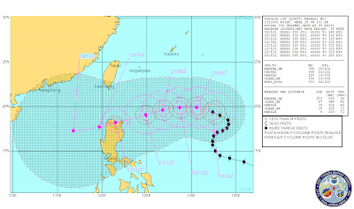
The latest track forecasts for Typhoon Mirinae (Santi) suggest that a direct hit on Luzon is now highly likely:
Mirinae is not especially strong in terms of windspeed, but the eTRaP data suggest that rainfall volumes are high (this is the precipitation forecast for the next 24 hours):

The topography of this area is pretty mountainous, and the typhoon will pass close to Manila:

The ground is likely to still be very wet from the two earlier typhoon events, although in these residual soils the drainage rate is probably quite high, so there is probably a higher likelihood of landslides than would normally occur for a typhoon of this size.

Thursday, October 29, 2009

Typhoon Mirinae (Santi)

Click here for the latest update

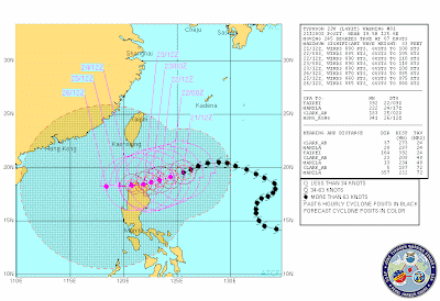
Once again Luzon in the Philippines is staring down the barrel of a powerful tropical cyclone, Typhoon Mirinae (known locally as Typhoon Santi). The storm is currently forecast to track across the southern part of Luzon on Friday evening:
The 24 hour eTRaP precipitation forecast for the storm suggests that it is, as expected, inducing substantial amounts of precipitation along track:

At the moment the storm is quite fast moving (15 knots) which from a precipitation perspective is probably good news. From a landslide perspective the worry however is that the storm appears likely to induce heavy rainfall in the areas most seriously affected by Typhoons Parma and Ketsana:

Indeed, the similarity between the track of Typhoon Ketsana and the forecast for Typhoon Mirinae is of some concern. Typhoon Ketsana killed at least 460 people.

Tuesday, October 27, 2009

Animation of Seattle harbour liquefaction failures

Youtube has a rather cool video of an animation of the effects of a large earthquake on the harbour side area of Seattle. The main point is I think to show the effects of the earthquake on the elevated roadway, but it also shows liquefaction failures of the fill behind the sea wall:


Pretty neat - certainly a useful teaching tool.

Monday, October 26, 2009

Just when you thought it was safe to go out in Luzon...

...another potential typhoon appears (Tropical Storm 23):

Unbelievable, although the track error this far out is of course very high.

Sunday, October 25, 2009

New atlas of natural disaster threats in the Andes

On Friday the Andean Community of Nations (CAN) (Bolivia, Colombia, Ecuador and Peru) released an atlas of potential natural disasters affecting the countries of that region, which has come out of the PREDECAN project. It presents maps of the distributions of earthquakes, volcanic eruptions, landslides, flooding, frost and drought, with a special emphasis on El Nino / La Nina.

As far as I can tell this atlas is available only in Spanish (not unreasonably of course), but it is available online in its entirety, which is certainly one better than the World Bank hotspots project. Of course I am most interested in the landslides section - and this deserves more than a single post - but for now let me just give an overview of the landslides chapter.

The headline figures in the analysis are that between 1970 and 2007 about 11,000 people were killed and 38,000 homes were destroyed by landslides. About 260 landslides killed more than 20 people and/or destroyed more than 50 houses. El Nino is a key control on the occurrence of slides. The following map presents the distribution of fatal landslides, with the size of the spot representing the number of fatalities in each case. The darker grey area is the zone covered by this study:

The study also presents the results of an analysis of trends of occurrence of larger (20+deaths and/or 50+ homes destroyed) landslide accidents:

Clearly the data suggest that more landslides have occurred since the mid 1980's than before, but this may well be an artifact of the data. Note that since the mid 1990's there is no clear overall trend, although the period in the late 1990s characterised by the large El Nino event is clearly evident in the data. A moderate El Nino event is thought to be developing at present.

Friday, October 23, 2009

Typhoon Lupit stalls off the coast of Luzon

Typhoon Lupit (Ramil) has now stalled off the northern coast off Luzon and is forecast to recurve and to head northwards, whilst weakening as it encounters increasingly cold water over the next few days:

This has been an extremely fortunate outcome, and one that has also exposed the continuing problems with forecasting typhoon tracks. The eTRap forecast for the precipitation over the next 24 hours clearly highlights just how close this storm came to causing substantial rainfall in Luzon:

The threat to Luzon has certainly not gone away completely, but is certainly receding substantially. Luckily, at the moment the storm is also forecast to miss Taiwan as well. Unless there is a dramatic change of direction of the storm this will be my last post on Lupit.

Wednesday, October 21, 2009

Typhoon Lupit (Ramil) continues to confound!

The behaviour of Typhoon Lupit (Ramil) is becoming increasingly difficult to forecast, primarily because its movement remains quite slow. The latest JTWC track forecast is still suggesting that the track will pass across the northern part of Luzon:
However, the storm is now moving slowly and is likely to continue to do so, which makes forecasting its track much more difficult. The major concern is that the JTWC forecast above suggests that the storm will track across Luzon very slowly, which is very bad news in terms of landslide and flood generation. However, some forecast models (such as the GFS model) suggest that the slow movement may allow the regional air pattern to change, which could cause the storm to recurve and head to the north, which would spare Luzon. This remains quite unlikely, but would be very fortunate indeed. On the other hand, some other forecasts suggest a more southerly track than the JTWC one.

The storm itself is now quite weak (only a category 2), but may well strengthen a little over the next few hours. This suggests that if the storm does come ashore the major issue will be the rainfall rather than the winds / storm surge. The eTRaP data, which forecasts rainfall for the next 24 hours, indicates the intensity of the rainfall associated with this storm (NB the scale is in inches, 1 inch = 25.4 mm):

The satellite imagery suggests that the outer edge of the storm (i.e. the high level cloud) has just about reached the Luzon coast, although the main part of the storm is still quite some distance away:


If the storm does come ashore then an interesting site to keep an eye on might be that of a professional extreme weather photographer, John Edds, who is out there and is blogging on the preparations that the local people are taking. You can view his report here.

Tuesday, October 20, 2009

Updates on the Nile River (Naches) landslide

Clearly the Nile River (Naches) landslide has effectively dropped off the media radar now. However, there are some excellent ongoing posts on this slide on the Sliding Though blog, which the is the Washington State landslide blogsite. You can access these posts here:

http://slidingthought.wordpress.com/


Typhoon Lupit (Typhoon Ramil) continues to threaten Luzon

Latest update here

Typhoon Lupit (Ramil) has now resumed its westward progress and remains on track to cross the northern part of Luzon in the Philippines:
The typhoon has weakened somewhat over the last few hours, with maximum sustained wind speeds now in the order of 85 knots. This weakening appears to be associated with some drier air that surrounded the typhoon, disrupting its organised circulation. However, there is now some evidence that it is stabilising and the eye is reforming. The typhoon is likely to cross an area of warmer water as it approaches Luzon, meaning that it may re-intensify somewhat:

NOAA eTRaP data provides an estimate of the likely precipitation associated with the storm over the next 24 hours. This is useful as the typhoon approaches land, but for now it provides a helpful indication of the levels of rainfall associated with the storm:
This storm continues to be the source of very serious concern. Based on its current quite low rate of movement (8 knots) the eye is likely to make landfall on Friday, although of course the outer rain bands will start to affect the area some time before that.

New York Times article on landslides

There is quite a nice article on recent attempts to monitor and provide warning against landslides in yesterday's New York Times:

http://www.nytimes.com/2009/10/20/science/20mud.html?pagewanted=1&_r=1

There is a small quote in there from me, but my role is very much as support to the main players in this case.

Monday, October 19, 2009

Typhoon Parma (Pepeng) - some interesting images

Thanks to Dr Deirdre McKay from Keele University for highlighting these images to me.

Inan Lanoi has an album of photographs taken in the aftermath of Typhoon Parma (Pepeng) in the Philippines. Whilst perhaps less polished than the images that one gets on news sites, they capture very well the true impact of the landslides. The images can be viewed on Inan's Facebook page here (you need a Facebook account to view this album).

I have taken the liberty to reproduce a couple of images here, primarily because I want to keep this event at the forefront of our minds, given the impending threat from Typhoon Lupit. This is the landslide at Kayan, Tadian, which reportedly killed 35 people:

Latest update on Typhoon Lupit (Typhoon Ramil) and Hurricane Rick

Latest update here

Unfortunately the news on typhoon Lupit (Ramil in the Philippines) is not getting any better. The storm has now turned towards the west and is picking up speed. It is now moving on a bearing of about 300 degrees at about 9 knots (c.17 kmh). This means that it is forecast to start to make landfall on the northern side of Luzon on Wednesday / Thursday. The current forecasts are that it will weaken slightly over the next few days, but this will still be a very strong storm if it does come ashore on Luzon:

The best hope at the moment is that it takes a more northerly track and shoots through the gap between Taiwan and Luzon. A more northerly track than this could be bad news for Taiwan - this is of course the area that was hit by Morakot (see images here and a review here) in August.

Meanwhile, in the Eastern Pacific Hurricane Rick is now weakening slightly but is heading northwards to make landfall on Baja California, also on Wednesday:
This storm also has the potential to bring very heavy rainfall, in this case to Mexico, with a very real threat of landslides.

Sunday, October 18, 2009

Typhoon Lupit (Ramil) update

Latest update here

According to the latest track maps, Typhoon Lupit (known locally as Typhoon Ramil in the Philippines) has been effectively stalled out to the east of Luzon for the last couple of days. It may look as if the storm is now heading away from Luzon, but current forecasts are that it will resume its westward movement in the next day or so:
This is a very large and strong storm (current maximum sustained speeds are 175 km per hour, with gusts up to 210 kph). Unfortunately, it is expected to hit Luzon on Wednesday or Thursday if the storm follows the forecast track. Given the impact of the two previous storms, the consequences are potentially grave, especially if it were to track slightly further to the south than the current forecast. Unsurprisingly, there is deep concern about this storm in the Philippines - take a look for example at this article.

Typhoon Parma - rainfall and landslide maps

NASA have recently produced a map of the distribution of rainfall from Typhoon Parma (Pepeng) in the Philippines:

The map has been produced from "the Multisatellite Precipitation Analysis, which includes rainfall observations from many satellites that are calibrated to match more detailed rainfall observations from the Tropical Rainfall Measuring Mission". I am not sure how reliable this is, but it is certainly a useful first estimate.

I thought it would be interesting to compare the distribution of fatal landslides with this map. I have used the amazing NDCC daily reports to compile a map of the landslides that killed people. I can only locate the slides to within a couple of kilometres, but for this exercise that is good enough. So here is a Google Earth map of the fatal landslides:

Each dot is a single fatal landslide - click on the image for a better view in a new window. Note the cluster in the centre of the image - this is Baguio City where there were many slides.


Not a bad relationship actually, but far from simple - but then fatal landslides are certainly not simple things.

Comments welcome.

Friday, October 16, 2009

The Naches / Nile River landslide and the role of the quarry

Spectacular image of the Naches / Nile River landslide, from the Washington State DNR Flickr site

Hat tip to Andrew Giles for pointing this out to me.

The Seattle Times have run an article today about the role of the quarry in the triggering of the Naches landslide. They quite rightly point out that there is no firm evidence either way as to whether the quarry played a role or not, but the do make some interesting comments about the possible role:

"Washington's Department of Natural Resources warned a Naches, Yakima County, gravel pit four years ago that its operations might be destabilizing a portion of the slope that collapsed onto Highway 410 this week. Records from 2005 show a department geologist noticed a 10-foot-wide fissure between the towering basalt cliffs and a broad talus slope below. The gravel mine appeared to have removed deposits that were buttressing the slope, documents say. "Your surface mining activity may be exacerbating slope instability and, therefore, may be creating a potential hazard to adjacent property and danger to the public health, safety (and) welfare," says a notice issued to the mine owners in September 2005."


The article quotes Prof. David Montgomery from the University of Washington, who is undeniably a world class academic geologist:

"It's definitely premature to rule out the gravel pit as a contributing factor...They were definitely digging at the toe of an active landslide, and that's a recipe for a slide."


The article then goes on to note that the Department of Natural Resources (DNR) wrote a letter dated July 2008 that noted that the agency still had not received a monitoring plan.

The image above clearly shows that this is primarily a slump/rotational failure as outlined in my previous post. This is rather beautifully illustrated by the image below, also from Washington State DNR Flickr site. The back-tilting of the trees are a sure-fire sign that the slope has rotated:

There is undoubtedly some translational movement too, as would be expected in such a large failure.

Another threat to the Philippines - Typhoon Lupit

Unfortunately things do not get any easier in the Philippines. Just as the clear-up from Typhoon Parma really gets under way (my tally of the landslide related deaths from this event is currently 346 people), another typhoon has formed. The current track forecasts suggest that there is a reasonable chance that it will pass over the northern part of Luzon once again:

Note that the labels on the track give the date and time - i.e. 21/00Z represents midnight (UT) on 21st, so the storm is some days away. Track forecasts are quite unreliable (that is what the shaded area represents), but the danger here is very real. With the ground being very wet from earlier events, a direct hit from this storm could be very serious. My experience is that late season typhoons (and this is most definitely late in the season) often seem to be quite damaging, although I have no empirical evidence to support that observation.

Wednesday, October 14, 2009

Teachers First presentation on the hazards associated with the Wenchuan (Sichuan) earthquake

This is a 45 minute presentation that I gave today at a seminar for sixth form (High School) teachers on the impact of the Wenchuan (Sichuan) Earthquake in May 2008. You should be able to view or download the presentation below. Please feel free to use it as appropriate for educational purposes, but please acknowledge me.


If the above presentation does not work you should be able to access the presentation here.

Tuesday, October 13, 2009

So what caused the Naches landslide?

The Naches landslide, as I reported in my post yesterday, is a somewhat intriguing failure. The weather conditions were dry, the rivers are in low flow conditions, and there has not been an earthquake that could have caused the failure. So what happened?

A clue may be in the landslide type. Several reports have suggested that the initial failure was a rotational slide. I am struggling slightly to get a proper appreciation of the slide (does anyone know where there is a decent set of images taken from an aircraft or a helicopter?), but a quick inspection of the images from the galleries that Heidi posted in the comments from yesterday's post is helpful. These three images, from this Washington State DoT gallery, are particularly helpful:

First, this one appears to show the highway uplifted well above the previous position (compare this with the Google Earth image here):


The second one appears to show the uplifted road and the gravels and cobbles from the river bed also uplifted well above the previous position:


Finally, this one also seems to show greatly uplifted river bed material:

Some of the other images even show dead fish amongst this material, so there is not much doubt what this is.

So how can the river bed be uplifted in this way by a landslide coming off the hillside. One possible explanation (lets call it a working hypothesis - I must stress that this is very tentative on the basis of the images) is that this is indeed a rotational slide. A typical rotational landslide looks like this (image from Geoscape Calgary):

Notice how the movement has occurred on a curved surface - this is what makes the slide rotational. Notice also how material at the toe (foot) of the slide is lifted up due to the movement on the curved surface. Sometimes fragmentation of the blocks in this area causes flows to develop, but often this takes some time as the block starts to break up and weather. So, the uplifted road and riverbed is consistent with a rotational slide, although this is still only a hypothesis. In reality the images suggest that the slide is probably rather more complex than that shown above, but the essence may be a rotational failure.

If that is the case, why did it fail. Well, for most rotational failures movement is the result one or more of three causes:
  1. The strength of the materials on the shear surface reduces. This is most likely to be the effect of rainfall causing high water pressures, although in this case that appears unlikely (although a leaking pipe or similar can sometimes be a factor). Materials sometimes degrade with time as well, causing a so-called progressive failure that usually has no trigger, so this is a possibility. If that is that is the case, and such failures are quite rare but definitely do occur, the slope should have shown lots of signs of problems for some time prior to failure;
  2. Mass is added to the slope at the top of the block that fails, which adds to the driving force, triggering failure. Sometimes dumping of spoil or garbage on the slope can trigger failures of this type. No such process is evident here, but it is possible.
  3. Mass was taken away from the toe of the slope. Much of the resistance to movement in a rotational slip comes from the material at the toe. Indeed, a common way to stabilise a rotational slide is to add mass the toe (often called a toe weight). A good example is the rotational landslide at Folkstone Warren in the UK (image from here):
The huge structure at the bottom of the slope is a toe weight designed to buttress the slope to prevent a rotational failure, and thus to protect the railway line.

So, removal of the material at the toe (or low on the slope) could be enough to cause failure.

Therefore, if I was asked to look at this slide I would do the following:
  1. Work out what type of failure this is - i.e. is it a rotational slide?
  2. Find out whether there were any water pipes or suchlike on the slope that might have been leaking, or anything that might have been feeding water into the slope from above;
  3. See whether anyone had dumped a substantial amount of material high up on the slope;
  4. See whether anyone had removed material from low on the slope.
I know where my immediate suspicions would lie, but a proper investigation is needed. It may well be the case that the failure occurred because of a chain of events involving two or more of the possible causes outlines above.

Monday, October 12, 2009

Updated and corrected: Large rockslide in Naches, Yakima County, Washington State

Updated: correct landslide location - thanks to various readers (especially Andrew Giles and Steve in ATL) for helping me to get this right - and apologies for the earlier error.

I have posted an update to this post here.

Various media agencies (e.g. here, here and here) are reporting a large landslide at Naches in Yakima County, Washington State, USA, which has blocked state highway. The Seattle Times has a spectacular photograph:


There is also a rather nice (if a little dramatic) video here.

As can be seen from the above video and picture the slide is large (the news reports suggest half a mile (about 750 m) and large. The slide appears to have come down in good weather.

The landslide appears to have come off this slope (from Google Earth) (this is now the corrected location):


A couple of very quick observations about this:
1. As a couple of commenters have noted, there appears to be a quarry on the right side of the area that has failed.
2. Above the road there appears to be what could be a smaller slump with a large scarp, although the quality of the image is not good enough to tell properly:


See the update to this post here.

Sunday, October 11, 2009

Update: landslides triggered by typhoon Parma (Pepeng) in the Philippines

This is an update on this post.

Information continues to trickle in about the landslides triggered by typhoon Parma (known as Pepeng in the Philippines). The following is a compilation from a variety of sources.
  • The confirmed current toll is 193 dead, with 101 injured and 46 people reported missing;
  • The landslide in Puguis village in La Trinidad (Benguet) is known to have killed 104 people, with rescue operations continuing;
  • The major road network in Benguet remains severely affected, with about 40 landslides blocking passage;
  • (from here) In Baguio City itself 53 people were killed in landslides into shanty towns. This includes 12 people in a slide at Barangay Crescencia on Thursday; 11 people (and 1 missing) in Barangay Irisan; and eight from a slide in Lower Kitma;
  • In Sitio Bulala, Barangay Kayan East in Tadian town, Mountain Province, 38 bodies have been recovered from a large landslide. A further 10 people are reported to be missing;
  • In Bunga in Tadian town, a residential house was buried on Thursday afternoon, killing three people.
I feel deeply frustrated by this disaster. Most of the fatal landslides occurred on Thursday of last week (8th October). I first posted on the dangers of this typhoon on Thursday 1st October (a week before the disaster!):

"...it is currently forecast to move rather slowly as it crosses Luzon, and then to hang around for a while. Note that forecasts this far in advance are quite uncertain, but if the current forecast track is maintained then things will get very nasty in the northern Philippines, given how wet the ground must be after Typhoon Ketsana."

Then on Friday 2nd October, I wrote:
"The main point of this post is to highlight the continued threat of Typhoon Parma to the northern Philippines. The current track forecast has it making landfall in the next day or so in the northern part of Luzon. The forecasts are still that it will stall as it makes its way across that area - this is typically the scenario that leads to very heavy rainfall and hence many landslides".

Video of the aftermath of landslides triggered by Typhoon Parma in the Philippines

Latest update here.

Youtube has an interesting video of the aftermath of the Philippine landslides triggered by Typhoon Parma (known locally as Pepeng):


If the above does not work you can access it via the following link:

http://www.youtube.com/watch?v=NuF1KFXBqAs&feature=related

Saturday, October 10, 2009

The rising toll from Typhoon Parma in the Philippines

Latest update on the landslides in the Philippines here.

The death toll in the Philippines from Typhoon Parma continues to rise. Fortunately, according to the track map (from here) the storm has now moved out into the South China Sea and is heading for Hainan Island in China:
In its wake the typhoon has left a train of landslide devastation. Combining reports from inquirer.net and GMANews.tv, the picture appears to be as follows:

Total death toll in the Cordillera region is 214-222 people. A further 53 people are reported to be missing. Most of the deaths are from landslides.

The largest event occurred at Barangay Puguis in La Trinidad town, where 64 people are known to have died and a further 24 are reported to be buried in the debris. At Barangay Abatan in Buguias a further 19 people were killed in a signle landslide.

Reuters have published the following images of the landslides in the Bagui area:


Whilst AP has published this one:


If anyone in the Philippines has any further information I would be really pleased to hear from them.

Latest update here.

Friday, October 9, 2009

Typhoon Parma - multiple landslide fatalities in the Philippines

Updated: ABS-CBN News are now reporting that "At least 45 bodies have been recovered while dozens more remain missing after a massive landslide buried dozens of houses in La Trinidad, Benguet on Thursday night while tropical depression Pepeng (international codename Parma) was pouring heavy rains over northern Luzon provinces."

At the end of last week I posted regarding my concerns about the impact of Typhoon Parma on the northern part of Luzon, in particular in relation to the likelihood that it might stall, leading to prolonged heavy rain in this area. Unfortunately, these fears came to pass - the typhoon has been sitting over the northern part of Luzon for several days now, and remains located over the same area, as shown by this map (which also shows the forecast track):

The upshot has been that Luzon has received heavy rain for many days, as this 7 day TRMM rainfall map shows:


The impact is all too predictable I am afraid. This morning the Philippines news agencies are reporting over 100 people killed in the affected area. There have been at least two large landslides. GMA News and others are reporting the following:
  • In the Puguis village, La Trinidad, 34 houses were buries when "a portion of the mountain collapsed". [Original post: 28] 45 [updated from here] bodies have been recovered, and many more may be missing.
  • In Poblacion village, nine people were killed in a landslide
  • In Barangay Tabio, Mankayan town, four people were killed when they were buried inside their house by a landslide
  • In Tublay town, six people were reported to have been buried in a landslide, including an infant. A worker at the provincial engineering office also killed in a landslide while clearing a road.
  • In Bugias town, two people were killed by a landslide.
In addition, GMA News note that "Retrieval operations are on going for 150 other Benguet residents believed to have been buried beneath the collapsed soil in the affected areas."

Unfortunately the typhoon track above suggests that this area has still to receive some further very heavy rainfall, so the picture may get considerably worse.

Thursday, October 8, 2009

A late monsoon landslide incident in Nepal

Regular readers will know that Nepal is country in which I have a particular interest. The landslides there are dominated by the very strong monsoonal signal seen in the summer months. Usually by late September the monsoon is fading and normal life resumes. Not this year, which has seen a sudden late burst of rainfall in the west of the country. The map below shows the TRMM data for the last three days, with areas of intense rainfall highlighted in red and yellow colours:


It is possible to extract from the TRMM site the actual rainfall data that sits behind this map. So here is the cumulative rainfall for this region over the last week. This should be taken as being indicative only, but it is clear that there has been a substantial amount of rain:

The consequence has been a large number of landslides, several of which have killed people. To date the list that I have collated is as follows:

Date Location Number of fatalities
06/10/2009 Mastamandu VDC 1, Garkhagaon, Dadeldura 12
06/10/2009 Dewrali VDC 3, Tanahu 1
06/10/2009 Silgadhi-14, Pagari in Doti district 1
06/10/2009 Patalkot VDC of Achham 13
06/10/2009 Bindyabasini-1, Accham 1
06/10/2009 Majhigaun-3, Bajhang 2
06/10/2009 Malladehi-7, Baitadi 1
06/10/2009 Siddheswari VDC, Accham 5
07/10/2009 Thapakhana village, Parvat 4
07/10/2009 Marku VDC of Achham 3
08/10/2009 Syadi VDC, Dhangadhi 4
Total
47

This is a pretty grim total. Fortunately, the weather does now seem to be improving.

Wednesday, October 7, 2009

More images of the earthquake-triggered landslides in Sumatra

I thought it would be useful to provide a compilation of images of the landslides triggered by the Sumatra earthquake. ReliefWeb is reporting that over 1000 landslides were triggered: "Landslides have hindered relief efforts in some areas. The West Sumatra Satkorlak reported at least 1,000 landslide spots in Gunung Tigo highlands, located between Padang Pariaman and Agam districts. Six helicopters carrying food and medical supplies were dispatched to the highlands as landslides blocked roads." Interestingly, the landslides appear to be highly mobile, (comparatively but not very) shallow flows in deeply weathered soils. They have run out over quite large distances and in some of the images there appears to be large amounts of water present.

From here, "A highway is severely damaged by a landslide after an earthquake occured near the Padang Alai village area in Pariaman, West Sumatra province"
From Reuters, "A motorbike is covered in mud after it was unearthed in the earthquake ravaged village of Tandikat, Indonesia's West Sumatra province October 6, 2009".


From Reuters, "An aerial view of a village hit by a landslide which occurred when an earthquake hit the area in Pariaman district, West Sumatra province October 6, 2009."


From Reuters, "An aerial view of villages hit by a landslide which occurred when an earthquake hit the area in Pariaman district, West Sumatra province October 6, 2009."


From Reuters, "An aerial view of villages hit by a landslide which occurred when an earthquake hit the area in Pariaman district, West Sumatra province October 6, 2009."

From Reuters, "Indonesian soldiers and police search victims buried after a quake-triggered landslide in Jumanak in Padang Pariaman district, Indonesia, Monday, Oct. 5, 2009."

From Reuters, "An aerial view of the damage after a landslide caused by a powerful earthquake in Limo Koto Timur village in Padang , Indonesia's West Sumatra province, October 4, 2009."