The behaviour of Typhoon Lupit (Ramil) is becoming increasingly difficult to forecast, primarily because its movement remains quite slow. The latest
JTWC track forecast is still suggesting that the track will pass across the northern part of Luzon:
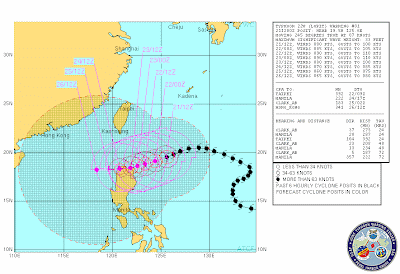
However, the storm is now moving slowly and is likely to continue to do so, which makes forecasting its track much more difficult. The major concern is that the JTWC forecast above suggests that the storm will track across Luzon very slowly, which is very bad news in terms of landslide and flood generation. However, some forecast models (such as the GFS model) suggest that the slow movement may allow the regional air pattern to change, which could cause the storm to recurve and head to the north, which would spare Luzon. This remains quite unlikely, but would be very fortunate indeed. On the other hand, some other forecasts suggest a more southerly track than the JTWC one.
The storm itself is now quite weak (only a category 2), but may well strengthen a little over the next few hours. This suggests that if the storm does come ashore the major issue will be the rainfall rather than the winds / storm surge. The
eTRaP data, which forecasts rainfall for the next 24 hours, indicates the intensity of the rainfall associated with this storm (NB the scale is in inches, 1 inch = 25.4 mm):

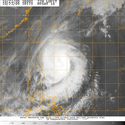
The
satellite imagery suggests that the outer edge of the storm (i.e. the high level cloud) has just about reached the Luzon coast, although the main part of the storm is still quite some distance away:
If the storm does come ashore then an interesting site to keep an eye on might be that of a professional extreme weather photographer, John Edds, who is out there and is blogging on the preparations that the local people are taking. You can view his report
here.
 This has been an extremely fortunate outcome, and one that has also exposed the continuing problems with forecasting typhoon tracks. The eTRap forecast for the precipitation over the next 24 hours clearly highlights just how close this storm came to causing substantial rainfall in Luzon:
 The threat to Luzon has certainly not gone away completely, but is certainly receding substantially. Luckily, at the moment the storm is also forecast to miss Taiwan as well. Unless there is a dramatic change of direction of the storm this will be my last post on Lupit.


