Showing posts with label philippines. Show all posts

Friday, October 30, 2009

Typhoon Mirinae (Santi) is likely to pass across Luzon in the next 24 hours

The latest track forecasts for Typhoon Mirinae (Santi) suggest that a direct hit on Luzon is now highly likely:
Mirinae is not especially strong in terms of windspeed, but the eTRaP data suggest that rainfall volumes are high (this is the precipitation forecast for the next 24 hours):

The topography of this area is pretty mountainous, and the typhoon will pass close to Manila:

The ground is likely to still be very wet from the two earlier typhoon events, although in these residual soils the drainage rate is probably quite high, so there is probably a higher likelihood of landslides than would normally occur for a typhoon of this size.

Thursday, October 29, 2009

Typhoon Mirinae (Santi)

Click here for the latest update

Once again Luzon in the Philippines is staring down the barrel of a powerful tropical cyclone, Typhoon Mirinae (known locally as Typhoon Santi). The storm is currently forecast to track across the southern part of Luzon on Friday evening:
The 24 hour eTRaP precipitation forecast for the storm suggests that it is, as expected, inducing substantial amounts of precipitation along track:

At the moment the storm is quite fast moving (15 knots) which from a precipitation perspective is probably good news. From a landslide perspective the worry however is that the storm appears likely to induce heavy rainfall in the areas most seriously affected by Typhoons Parma and Ketsana:

Indeed, the similarity between the track of Typhoon Ketsana and the forecast for Typhoon Mirinae is of some concern. Typhoon Ketsana killed at least 460 people.

Monday, October 26, 2009

Just when you thought it was safe to go out in Luzon...

...another potential typhoon appears (Tropical Storm 23):

Unbelievable, although the track error this far out is of course very high.

Friday, October 23, 2009

Typhoon Lupit stalls off the coast of Luzon

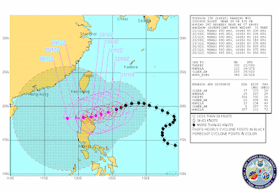
Typhoon Lupit (Ramil) has now stalled off the northern coast off Luzon and is forecast to recurve and to head northwards, whilst weakening as it encounters increasingly cold water over the next few days:

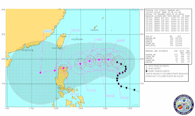
This has been an extremely fortunate outcome, and one that has also exposed the continuing problems with forecasting typhoon tracks. The eTRap forecast for the precipitation over the next 24 hours clearly highlights just how close this storm came to causing substantial rainfall in Luzon:

The threat to Luzon has certainly not gone away completely, but is certainly receding substantially. Luckily, at the moment the storm is also forecast to miss Taiwan as well. Unless there is a dramatic change of direction of the storm this will be my last post on Lupit.

Wednesday, October 21, 2009

Typhoon Lupit (Ramil) continues to confound!

The behaviour of Typhoon Lupit (Ramil) is becoming increasingly difficult to forecast, primarily because its movement remains quite slow. The latest JTWC track forecast is still suggesting that the track will pass across the northern part of Luzon:
However, the storm is now moving slowly and is likely to continue to do so, which makes forecasting its track much more difficult. The major concern is that the JTWC forecast above suggests that the storm will track across Luzon very slowly, which is very bad news in terms of landslide and flood generation. However, some forecast models (such as the GFS model) suggest that the slow movement may allow the regional air pattern to change, which could cause the storm to recurve and head to the north, which would spare Luzon. This remains quite unlikely, but would be very fortunate indeed. On the other hand, some other forecasts suggest a more southerly track than the JTWC one.

The storm itself is now quite weak (only a category 2), but may well strengthen a little over the next few hours. This suggests that if the storm does come ashore the major issue will be the rainfall rather than the winds / storm surge. The eTRaP data, which forecasts rainfall for the next 24 hours, indicates the intensity of the rainfall associated with this storm (NB the scale is in inches, 1 inch = 25.4 mm):

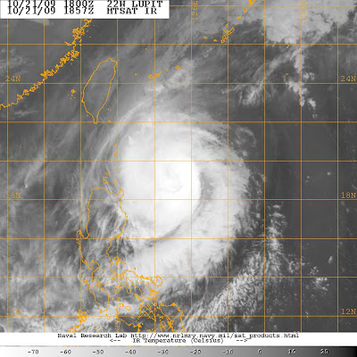
The satellite imagery suggests that the outer edge of the storm (i.e. the high level cloud) has just about reached the Luzon coast, although the main part of the storm is still quite some distance away:


If the storm does come ashore then an interesting site to keep an eye on might be that of a professional extreme weather photographer, John Edds, who is out there and is blogging on the preparations that the local people are taking. You can view his report here.

Tuesday, October 20, 2009

Typhoon Lupit (Typhoon Ramil) continues to threaten Luzon

Latest update here

Typhoon Lupit (Ramil) has now resumed its westward progress and remains on track to cross the northern part of Luzon in the Philippines:
The typhoon has weakened somewhat over the last few hours, with maximum sustained wind speeds now in the order of 85 knots. This weakening appears to be associated with some drier air that surrounded the typhoon, disrupting its organised circulation. However, there is now some evidence that it is stabilising and the eye is reforming. The typhoon is likely to cross an area of warmer water as it approaches Luzon, meaning that it may re-intensify somewhat:

NOAA eTRaP data provides an estimate of the likely precipitation associated with the storm over the next 24 hours. This is useful as the typhoon approaches land, but for now it provides a helpful indication of the levels of rainfall associated with the storm:
This storm continues to be the source of very serious concern. Based on its current quite low rate of movement (8 knots) the eye is likely to make landfall on Friday, although of course the outer rain bands will start to affect the area some time before that.

Monday, October 19, 2009

Typhoon Parma (Pepeng) - some interesting images

Thanks to Dr Deirdre McKay from Keele University for highlighting these images to me.

Inan Lanoi has an album of photographs taken in the aftermath of Typhoon Parma (Pepeng) in the Philippines. Whilst perhaps less polished than the images that one gets on news sites, they capture very well the true impact of the landslides. The images can be viewed on Inan's Facebook page here (you need a Facebook account to view this album).

I have taken the liberty to reproduce a couple of images here, primarily because I want to keep this event at the forefront of our minds, given the impending threat from Typhoon Lupit. This is the landslide at Kayan, Tadian, which reportedly killed 35 people:

Latest update on Typhoon Lupit (Typhoon Ramil) and Hurricane Rick

Latest update here

Unfortunately the news on typhoon Lupit (Ramil in the Philippines) is not getting any better. The storm has now turned towards the west and is picking up speed. It is now moving on a bearing of about 300 degrees at about 9 knots (c.17 kmh). This means that it is forecast to start to make landfall on the northern side of Luzon on Wednesday / Thursday. The current forecasts are that it will weaken slightly over the next few days, but this will still be a very strong storm if it does come ashore on Luzon:

The best hope at the moment is that it takes a more northerly track and shoots through the gap between Taiwan and Luzon. A more northerly track than this could be bad news for Taiwan - this is of course the area that was hit by Morakot (see images here and a review here) in August.

Meanwhile, in the Eastern Pacific Hurricane Rick is now weakening slightly but is heading northwards to make landfall on Baja California, also on Wednesday:
This storm also has the potential to bring very heavy rainfall, in this case to Mexico, with a very real threat of landslides.

Sunday, October 18, 2009

Typhoon Lupit (Ramil) update

Latest update here

According to the latest track maps, Typhoon Lupit (known locally as Typhoon Ramil in the Philippines) has been effectively stalled out to the east of Luzon for the last couple of days. It may look as if the storm is now heading away from Luzon, but current forecasts are that it will resume its westward movement in the next day or so:
This is a very large and strong storm (current maximum sustained speeds are 175 km per hour, with gusts up to 210 kph). Unfortunately, it is expected to hit Luzon on Wednesday or Thursday if the storm follows the forecast track. Given the impact of the two previous storms, the consequences are potentially grave, especially if it were to track slightly further to the south than the current forecast. Unsurprisingly, there is deep concern about this storm in the Philippines - take a look for example at this article.

Typhoon Parma - rainfall and landslide maps

NASA have recently produced a map of the distribution of rainfall from Typhoon Parma (Pepeng) in the Philippines:

The map has been produced from "the Multisatellite Precipitation Analysis, which includes rainfall observations from many satellites that are calibrated to match more detailed rainfall observations from the Tropical Rainfall Measuring Mission". I am not sure how reliable this is, but it is certainly a useful first estimate.

I thought it would be interesting to compare the distribution of fatal landslides with this map. I have used the amazing NDCC daily reports to compile a map of the landslides that killed people. I can only locate the slides to within a couple of kilometres, but for this exercise that is good enough. So here is a Google Earth map of the fatal landslides:

Each dot is a single fatal landslide - click on the image for a better view in a new window. Note the cluster in the centre of the image - this is Baguio City where there were many slides.


Not a bad relationship actually, but far from simple - but then fatal landslides are certainly not simple things.

Comments welcome.

Friday, October 16, 2009

Another threat to the Philippines - Typhoon Lupit

Unfortunately things do not get any easier in the Philippines. Just as the clear-up from Typhoon Parma really gets under way (my tally of the landslide related deaths from this event is currently 346 people), another typhoon has formed. The current track forecasts suggest that there is a reasonable chance that it will pass over the northern part of Luzon once again:

Note that the labels on the track give the date and time - i.e. 21/00Z represents midnight (UT) on 21st, so the storm is some days away. Track forecasts are quite unreliable (that is what the shaded area represents), but the danger here is very real. With the ground being very wet from earlier events, a direct hit from this storm could be very serious. My experience is that late season typhoons (and this is most definitely late in the season) often seem to be quite damaging, although I have no empirical evidence to support that observation.

Sunday, October 11, 2009

Update: landslides triggered by typhoon Parma (Pepeng) in the Philippines

This is an update on this post.

Information continues to trickle in about the landslides triggered by typhoon Parma (known as Pepeng in the Philippines). The following is a compilation from a variety of sources.
  • The confirmed current toll is 193 dead, with 101 injured and 46 people reported missing;
  • The landslide in Puguis village in La Trinidad (Benguet) is known to have killed 104 people, with rescue operations continuing;
  • The major road network in Benguet remains severely affected, with about 40 landslides blocking passage;
  • (from here) In Baguio City itself 53 people were killed in landslides into shanty towns. This includes 12 people in a slide at Barangay Crescencia on Thursday; 11 people (and 1 missing) in Barangay Irisan; and eight from a slide in Lower Kitma;
  • In Sitio Bulala, Barangay Kayan East in Tadian town, Mountain Province, 38 bodies have been recovered from a large landslide. A further 10 people are reported to be missing;
  • In Bunga in Tadian town, a residential house was buried on Thursday afternoon, killing three people.
I feel deeply frustrated by this disaster. Most of the fatal landslides occurred on Thursday of last week (8th October). I first posted on the dangers of this typhoon on Thursday 1st October (a week before the disaster!):

"...it is currently forecast to move rather slowly as it crosses Luzon, and then to hang around for a while. Note that forecasts this far in advance are quite uncertain, but if the current forecast track is maintained then things will get very nasty in the northern Philippines, given how wet the ground must be after Typhoon Ketsana."

Then on Friday 2nd October, I wrote:
"The main point of this post is to highlight the continued threat of Typhoon Parma to the northern Philippines. The current track forecast has it making landfall in the next day or so in the northern part of Luzon. The forecasts are still that it will stall as it makes its way across that area - this is typically the scenario that leads to very heavy rainfall and hence many landslides".

Video of the aftermath of landslides triggered by Typhoon Parma in the Philippines

Latest update here.

Youtube has an interesting video of the aftermath of the Philippine landslides triggered by Typhoon Parma (known locally as Pepeng):


If the above does not work you can access it via the following link:

http://www.youtube.com/watch?v=NuF1KFXBqAs&feature=related

Saturday, October 10, 2009

The rising toll from Typhoon Parma in the Philippines

Latest update on the landslides in the Philippines here.

The death toll in the Philippines from Typhoon Parma continues to rise. Fortunately, according to the track map (from here) the storm has now moved out into the South China Sea and is heading for Hainan Island in China:
In its wake the typhoon has left a train of landslide devastation. Combining reports from inquirer.net and GMANews.tv, the picture appears to be as follows:

Total death toll in the Cordillera region is 214-222 people. A further 53 people are reported to be missing. Most of the deaths are from landslides.

The largest event occurred at Barangay Puguis in La Trinidad town, where 64 people are known to have died and a further 24 are reported to be buried in the debris. At Barangay Abatan in Buguias a further 19 people were killed in a signle landslide.

Reuters have published the following images of the landslides in the Bagui area:


Whilst AP has published this one:


If anyone in the Philippines has any further information I would be really pleased to hear from them.

Latest update here.

Friday, October 9, 2009

Typhoon Parma - multiple landslide fatalities in the Philippines

Updated: ABS-CBN News are now reporting that "At least 45 bodies have been recovered while dozens more remain missing after a massive landslide buried dozens of houses in La Trinidad, Benguet on Thursday night while tropical depression Pepeng (international codename Parma) was pouring heavy rains over northern Luzon provinces."

At the end of last week I posted regarding my concerns about the impact of Typhoon Parma on the northern part of Luzon, in particular in relation to the likelihood that it might stall, leading to prolonged heavy rain in this area. Unfortunately, these fears came to pass - the typhoon has been sitting over the northern part of Luzon for several days now, and remains located over the same area, as shown by this map (which also shows the forecast track):

The upshot has been that Luzon has received heavy rain for many days, as this 7 day TRMM rainfall map shows:


The impact is all too predictable I am afraid. This morning the Philippines news agencies are reporting over 100 people killed in the affected area. There have been at least two large landslides. GMA News and others are reporting the following:
  • In the Puguis village, La Trinidad, 34 houses were buries when "a portion of the mountain collapsed". [Original post: 28] 45 [updated from here] bodies have been recovered, and many more may be missing.
  • In Poblacion village, nine people were killed in a landslide
  • In Barangay Tabio, Mankayan town, four people were killed when they were buried inside their house by a landslide
  • In Tublay town, six people were reported to have been buried in a landslide, including an infant. A worker at the provincial engineering office also killed in a landslide while clearing a road.
  • In Bugias town, two people were killed by a landslide.
In addition, GMA News note that "Retrieval operations are on going for 150 other Benguet residents believed to have been buried beneath the collapsed soil in the affected areas."

Unfortunately the typhoon track above suggests that this area has still to receive some further very heavy rainfall, so the picture may get considerably worse.

Saturday, October 3, 2009

Landslide round-up: Philippines, India and Italy

1. Philippines
Typhoon Parma (known as Pepeng in the Philippines) has churned its way across the northern part of Luzon in the Philippines. Fortunately, its track took it north of the most vulnerable area, which is the first bit of good news for a while:


However, early reports are that the storm has triggered some landslides:

"Rains in Benguet province set off landslides in which at least 12 people were killed, police said. The victims included seven small-scale miners who were sleeping in a shelter when they were buried by one landslide, said provincial police chief Loreto Espeneli."

And this from GMA News in the Philippines:

"At least 12 people were killed in two landslides that hit their homes in Benguet province in" the wake of typhoon “Pepeng" (Parma), a radio report said Sunday. Radio dzBB’s Benjie Liwanag Jr. reported that seven people, including a family and two guests, were killed in a landslide in Sitio Manganese in Ampukao village in Itogon town. The incident occurred at about 2 a.m., the report said. The fatalities were not immediately named, but the report said the two guests were from Ifugao province."

"On the other hand, dzBB said five members of a family were buried in their house at Beckel village in La Trinidad town Saturday night. Their bodies were recovered Sunday morning."

2. India
The very heavy rain in southern India is continuing to cause major problems. On Friday it has been reported that a landslide struck Kadwad in Uttara Kannada district in North Karnataka:

"In Kadwad village, a landslide occurred in the Madibag area on Friday afternoon, where 24 people were buried alive when the nine houses collapsed. While a minor landslide had already occurred later, the people residing between the railway track and the hillock area of the village did not expect another landslide. But, by evening boulders and mud from the hill began rolling down and seven families bore the brunt of this negligence." (note I suspect that the use of the term "negligence" here may be a mistranslation"

3. Italy
The Italian news agency ANSA is now reporting that the loss of life in the mudslides in Messina at the end of last week is 22, but that this is likely to continue to rise. There appears to be growing anger about the links between this disaster and illegal construction.

Thursday, October 1, 2009

Typhoon Parma

Super typhoon Parma is now forecast to be heading for the northern part of the Philippines:

Even worse than that, it is currently forecast to move rather slowly as it crosses Luzon, and then to hang around for a while. Note that forecasts this far in advance are quite uncertain, but if the current forecast track is maintained then things will get very nasty in the northern Philippines, given how wet the ground must be after Typhoon Ketsana.

Monday, August 10, 2009

A dreadful weekend of landslides

The last few days have been a dreadful period for landslides. I really cannot cover all that has happened in enough detail, so all I can do is to outline the main events:

1. Rotorua rockfall, New Zealand
Actually the period started with a very lucky escape in New Zealand on Thursday when a rockfall on a slope under maintenance crushed a car with two passengers. Both were trapped but were extracted from the car with minimal injuries. Given the size of the blocks and the state of the car this is pretty remarkable image from here:


2. Shunhe township, Hanyuan county, Sichuan province, China
The large valley-blocking landslide in Hanyuan County also occurred on Thursday. This slide, which is reported here, is believed to have killed 31 people. The partial blockage of the river continues to cause problems:

3. Mount Pinatubo, Philippines
On Friday the Philippines was hit with very intense rainfall that appears to be from the outer edges of Typhoon Marakot, which hit Taiwan and then China. There were two disastrous landslides - in the first a lahar hit a tour group and their guides on the flanks of Mount Pinatubo, killing two locals and three tourists.

4. Kias, Baguio, Philippines
In the second incident, also on Friday, a landslide hit a group of miners at Kias, near to Baguio in the Philippines. A group who went to their rescue were then hit by a second landslide, killing 14 people in total.

5. Pithoragarh district, Uttarakhand
On Saturday a large landslide occurred in northern India (see image below from here). The true impact of this is a little unclear, but the current estimate of loss of life appears to be 43 people. Thanks to David Hopkins for the heads-up on this one, and to Sekhar for the photo).

6. Typhoon Marakot, Taiwan
The true impact of Typhoon Marakot is far from clear, with reports of debris flows that might have killed hundreds. It is important to stress that these are unconfirmed, but with 2.4 m of rainfall in a weekend who knows? A slightly clearer report suggests that Taoyuan Village in the county of Kaohsiung was hit by a debris flow that killed 16. We will wait for the morning to see whether the reports of much higher loss of life are correct.

Tuesday, May 19, 2009

Landslide in Campostela Valley, Philippines: >25 people killed

Image of the September 2008 landslide in Campostela Valley that killed >20 people (image from here)

A range of news agencies, including Al Jazeera and AFP, are reporting that there was a major landslide in Campostela Valley in the Philippines yesterday. Regular readers of this blog will be fairly familiar with this location, which appears to have a major fatal landslide every few months.

The event yesterday occurred in barangay Napnapan, Pantukan town in Campostela Valley province (see map below). The approximate coordinates are 7.15N 125.95E. I will try to pin down the location in more detail.

Campostela Valley has a large number of fatal landslides largely because the combination of tropical soils, intense rainfall events and unregulated mining is a very toxic mix. This slide is reported to have killed 26 people and left a further 19 missing (although I wouldn't be surprised if this latter number is an over-estimate - it often is). The scenario of the slide is a little confused - some reports suggest that it buried 20 houses in a shanty town, whilst others say that the victims were resting in a bunkhouse. The trigger appears to have been heavy rainfall.

I'll post an update when more info is available.