Showing posts with label lahar. Show all posts

Friday, September 10, 2010

Ruapehu lahar information

One of the many highlights of the splendid IAEG Congress in Auckland this week was a talk by GNS geologist Chris Massey on the 18th March 2007 lahar at Mount Ruapehu on North Island.  The lahar occurred as a result of the failure of a tephra wall holding back the crater lake at the summit, and is shown by this NASA image:


The potential for a lahar had been anticipated and the site was intensively monitored with real time instruments such as water level sensors and geophones; with  two web cams; and with periodic surveys using a terrestrial laser scanner.  An emergency plan was in place and worked well.  The need for caution was undeniable - on 24th December 1954 a lahar from the same site demolished a railway bridge at Tangiwai, killing 151 people on a train that tried to cross a bridge that had been destroyed by the lahar.

The event has been written up in a paper (Massey et al. 2010), and there is a spectacular set of images of the event captured by the web cam available here (NB it took me a while to get my eye into these images).   

An interesting aspect of this event is that one can examine just how good the natural hazard science community is at assessing hazard.  There is a New Zealand Civil Defence report, written in 2002, about the threat of a lahar at Ruapehu online here


Reference
Massey, C., Manville, V., Hancox, G., Keys, H., Lawrence, C., and McSaveney, M. 2010.  Out-burst flood (lahar) triggered by retrogressive landsliding, 18 March 2007 at Mt Ruapehu, New Zealand—a successful early warning.  Landslides 7 (3),303-315, DOI: 10.1007/s10346-009-0180-5.

Thursday, May 20, 2010

Volcanic landslide in the Democratic Republic of Congo

Whilst the Attabad landslide continues to be my major blogging preoccupation at the moment (I'm guessing you might have noticed...), of course other landslides continue to occur around the world.  On16th May a slip happened on Nyiragongo volcano in the Democratic Republic of Congo.  The reports suggest that 43 people are likely to have been killed, and a further 1,500 directly affected by this slide.


Nyiragongo volcano is active, so this is likely to be a lahar - i.e. a debris flow in volcanic deposits.  This Google Earth image, although of low resolution, suggests that this is not the first failure on the east side of this volvano:


The El Salvador landslides of last year provide a good indication of the nature of a lahar - see previous posts here, here and here.

Tuesday, November 24, 2009

More El Salvador lahar satellite imagery

In an earlier post today I highlighted the availability of satellite imagery covering the El Salvador lahar disaster, triggered by Hurricane Ida earlier this month. Whilst sitting in a conference session this morning it occurred to me that the Disaster Charter, which provides satellite images for disaster relief and recovery operation, was also triggered by this event. So I had a quick look at the web page for this triggering of the charter, and sure enough there are some good materials there.

Perhaps the best image is this interpretation of the lahar tracks, produce using the Taiwanese Formosat2 satellite (famous for its images of Beichuan and Tangjiashan after the Wenchuan Earthquake) - do click on the image to see this properly, it is worth it!:

There is also a more detailed look at the town of Guadeloupe using the same satellite, showing before and after images of the town:

Viewed in conjunction with the NASA images in my earlier post, this is a very useful resource.

Satellite imagery of the El Salvador lahars

NASA has released before and after satellite images of the lahars (volcanic debris flows) triggered by Hurricane Ida in El Salvador earlier this month. The final toll of the landslides remains unclear, over 60 is the widely reported statistic.

The images are false colour composites collected by the ASTER instrument. These images differentiate between vegetation, which appears as red colours, and bare ground, which appear as a blue-grey colour. Such images are ideal for delineating new landslides, which usually strip away vegetation to leave bare soil.

This is the before image of the area affected by the landslides:

As usual, click on the image for a better view in a new window. Here is the image after the hurricanes passed through:


The lahar tracks are pretty clear. Note that they start high on the volcano, mostly with small, translational landslides. These slides then enter the channel, entraining (eroding and incorporating) material along the channel. The towns are quite clear on the images - the debris flows have hit the settlements in several locations, leaving this type of damage (Image from here):


When the landslides reach the plains below the volcano they spread out and stop, leaving a large area covered in debris. This is also clear on the image.

Monday, November 9, 2009

El Salvador landslide disaster

The nature of the landslide disaster in El Salvador caused by Hurricane Ida is now becoming a little clearer. The largest event appears to have happened in the town of Verapaz, where it appears that a debris flow hit and destroyed part of the town. The reported death toll is 16 people, with a further 47 thought to be missing.

There are two intriguing aspects to this landslide. The first is that the maps seem to show that Verapaz is some distance from the San Vicente volcano (also known as Chichontepec volcano) from which the landslide (probably actually technically a lahar) came, as the Google Earth image below shows:

So, I wonder whether the landslide actually affected this town - in which case it is very large indeed- or whether it was one of the smaller communities nearer to the volcano.

Second, this area was affected by an earthquake on 13 February 2001, which killed over 300 people. www.elsalvador.com has an interesting comparison image:

This is clearly not the same street.

Acciording to this abstract, In that earthquake two landslides were triggered on San Vicente volcano (the volcano shown above). Part of the abstract states (note my emphasis):

"Large landslides dammed two major rivers, the Río El Desagüe and Río Jiboa, and two large slides occurred on Volcán San Vicente. The ±1.5-million-m3 Río El Desagüe landslide temporarily dammed the river and formed a shallow, 1.5-km-long lake, but the dam has been overtopped and is stable. The ±12-million-m3 Río Jiboa landslide blocked about 700 m of the valley with debris composed of poorly consolidated tephra, and the upstream lake could potentially have been as deep as 60 m and about 2 km long. A 20-m-deep spillway was excavated to decrease the maximum lake volume and reduce the possible catastrophic failure of the unstable landslide dam. On the northern flank of Volcán San Vicente, ±250,000 m3 of loose landslide debris filled the upper part of Quebrada El Blanco; remobilization of this material in debris flows could inundate part of a downstream village. On the volcano's northwest flank, ±200,000 m3 of lithified andesite blocks slid in the upper part of Quebrada Del Muerto, but this material will not likely remobilize and threaten downstream settlements.."

Verapaz is to the north of the volcano.

The presence of potentially dangerous landslides on the northern flank of the volcano is fairly clear:

Monday, August 10, 2009

A dreadful weekend of landslides

The last few days have been a dreadful period for landslides. I really cannot cover all that has happened in enough detail, so all I can do is to outline the main events:

1. Rotorua rockfall, New Zealand
Actually the period started with a very lucky escape in New Zealand on Thursday when a rockfall on a slope under maintenance crushed a car with two passengers. Both were trapped but were extracted from the car with minimal injuries. Given the size of the blocks and the state of the car this is pretty remarkable image from here:


2. Shunhe township, Hanyuan county, Sichuan province, China
The large valley-blocking landslide in Hanyuan County also occurred on Thursday. This slide, which is reported here, is believed to have killed 31 people. The partial blockage of the river continues to cause problems:

3. Mount Pinatubo, Philippines
On Friday the Philippines was hit with very intense rainfall that appears to be from the outer edges of Typhoon Marakot, which hit Taiwan and then China. There were two disastrous landslides - in the first a lahar hit a tour group and their guides on the flanks of Mount Pinatubo, killing two locals and three tourists.

4. Kias, Baguio, Philippines
In the second incident, also on Friday, a landslide hit a group of miners at Kias, near to Baguio in the Philippines. A group who went to their rescue were then hit by a second landslide, killing 14 people in total.

5. Pithoragarh district, Uttarakhand
On Saturday a large landslide occurred in northern India (see image below from here). The true impact of this is a little unclear, but the current estimate of loss of life appears to be 43 people. Thanks to David Hopkins for the heads-up on this one, and to Sekhar for the photo).

6. Typhoon Marakot, Taiwan
The true impact of Typhoon Marakot is far from clear, with reports of debris flows that might have killed hundreds. It is important to stress that these are unconfirmed, but with 2.4 m of rainfall in a weekend who knows? A slightly clearer report suggests that Taoyuan Village in the county of Kaohsiung was hit by a debris flow that killed 16. We will wait for the morning to see whether the reports of much higher loss of life are correct.

Friday, October 24, 2008

Forced to flee

IRIN, the UN Office for the Coordination of Human Affairs, has produced a rather nice video about the impact of lahars (a landslide in comparatively young volcanic materials) in the Philippines. The landslide occurred during Typhoon Durian (known in the Philippines as typhoon Reming) in 2006.

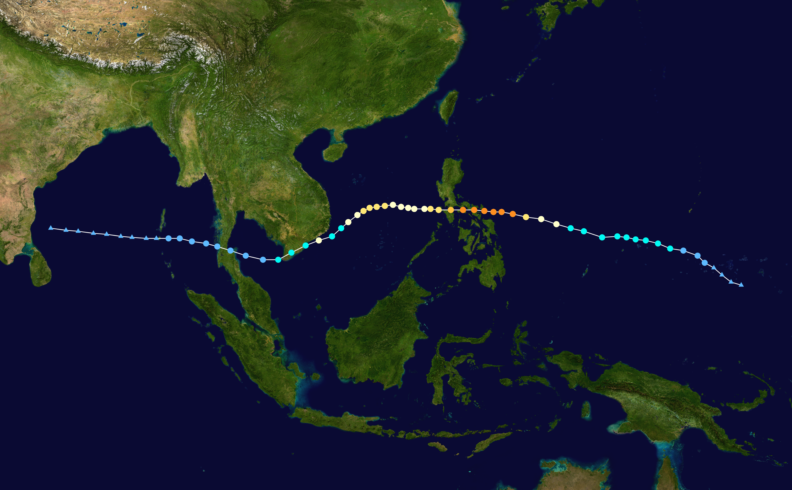
Wikipedia image of the track of typhoon Durian (Reming) in 2006. The orange dots indicate the locations at which the typhoon was at its maximum intensity

NASA image, derived from TRMM data, of the rainfall associated with typhoon Durian (Reming). Note that although 200 mm is very high, far greater rainfall totals are often associated with large typhoons.

Lahars surged down the flanks of Mount Mayon, killing over a thousand people. The film focuses on a comparatively affluent family whose house and land was hit by the lahar. The children's mother was killed, their house destroyed and their land inundated. In the aftermath the government declared the flanks of the volcano to be too hazardous, meaning that the family were moved into a refugee camp. The father of the family is relentlessly cheerful (except when he revisits his house and sees his wife's pillow), but his desperation is clear to see.

The film is available here.

Google Earth image of Mount Mayon, showing a lahar deposit. Click on the image for a full size view in a new window.

In many ways the most interesting aspect is the way that the film balances the hazards associated with the natural processes (i.e. the danger of another event) with the hazards associated with displaced people moving to new settlements that can quickly become slums. It is an interesting film that brings home some fundamental issues in a very real way, without presenting anything terribly new. It is certainly useful for teaching both in schools and at undergraduate level, and as a reminder to those of us working on hazards as to the complexity of the impact of decisions.

UNOSAT image of the impact of Typhoon Reming on Mount Mayon, showing in particular the multiple lahar tracks. Note the degree to which the lahars have impacted upon the towns.