Showing posts with label volcanic landslide. Show all posts

Friday, September 10, 2010

Ruapehu lahar information

One of the many highlights of the splendid IAEG Congress in Auckland this week was a talk by GNS geologist Chris Massey on the 18th March 2007 lahar at Mount Ruapehu on North Island.  The lahar occurred as a result of the failure of a tephra wall holding back the crater lake at the summit, and is shown by this NASA image:


The potential for a lahar had been anticipated and the site was intensively monitored with real time instruments such as water level sensors and geophones; with  two web cams; and with periodic surveys using a terrestrial laser scanner.  An emergency plan was in place and worked well.  The need for caution was undeniable - on 24th December 1954 a lahar from the same site demolished a railway bridge at Tangiwai, killing 151 people on a train that tried to cross a bridge that had been destroyed by the lahar.

The event has been written up in a paper (Massey et al. 2010), and there is a spectacular set of images of the event captured by the web cam available here (NB it took me a while to get my eye into these images).   

An interesting aspect of this event is that one can examine just how good the natural hazard science community is at assessing hazard.  There is a New Zealand Civil Defence report, written in 2002, about the threat of a lahar at Ruapehu online here


Reference
Massey, C., Manville, V., Hancox, G., Keys, H., Lawrence, C., and McSaveney, M. 2010.  Out-burst flood (lahar) triggered by retrogressive landsliding, 18 March 2007 at Mt Ruapehu, New Zealand—a successful early warning.  Landslides 7 (3),303-315, DOI: 10.1007/s10346-009-0180-5.

Sunday, March 21, 2010

A new submarine landslide at NW Rota, near Guam

The NW Rota volcano is located in the Mariana Volcanic Arc, about 100 km north of Guam at a depth of about 520 below sea level. NSF currently funds an scientific expedition to this active volcano; a scientific cruise to this site is currently occurring. The team are running a blog of their experiences and findings - it is here.

Yesterday they reported that in the time since their 2009 cruise the volcano has experienced a major landslide. The bathymetry data shows this rather well:

The landslide has caused up to 100 m of erosion from the summit area of the volcano (the blue areas on the map) and up to 40 m of deposition on the gentle lower slopes. These deposits extend for a distance of 8 km.

Sunday, November 8, 2009

Reports of a very large landslide tragedy at San Vicente volcano in El Salvador caused by Hurricane Ida?

It is becoming clear that Hurricane Ida has wreaked havoc in El Salvador over the last 48 hours, with many landslides. Over 100 people are known to have been killed, with the toll expected to rise over the next few days as more remote areas resume contacts. Intriguingly, the El Salvador news site ElSalvador.com has a report on the disaster here. It reports:

"Según los últimos reportes, en Verapaz, en las faldas del volcán de San Vicente, un alud ha cubierto un área de ocho kilómetros aproximadamente. El panorama es sombrío: Grandes rocas y árboles se observan por todos lados, por lo que la movilización es difícil. La tierra ha cubierto colonias enteras. Familiares y socorristas buscan desesperadamente a las víctimas. Testigos afirman que la tragedia es similar a la que ocurrió en Las Colinas, Santa Tecla, en 2001 cuando el país fue afectado por un terremoto."

This roughly translates as:

"According to recent reports, in Verapaz, in the foothills of the San Vicente volcano, a landslide has covered an area of eight kilometres. The outlook is grim: Large rocks and trees are found everywhere, so that mobilization is difficult. The earth has covered entire colonies. Relatives and rescuers desperately looking for victims. Witnesses say the tragedy is similar to what occurred in Las Colinas, Santa Tecla, in 2001 when the country was affected by an earthquake."

The Santa Tecla landslide killed about 600 people.

I have no way to validate or refute this report at this time, so let's hope that this report is erroneous. This is a Google Earth perspective view of the volcano in question, San Vicente:

I will post again when information becomes available.

Friday, October 24, 2008

Forced to flee

IRIN, the UN Office for the Coordination of Human Affairs, has produced a rather nice video about the impact of lahars (a landslide in comparatively young volcanic materials) in the Philippines. The landslide occurred during Typhoon Durian (known in the Philippines as typhoon Reming) in 2006.

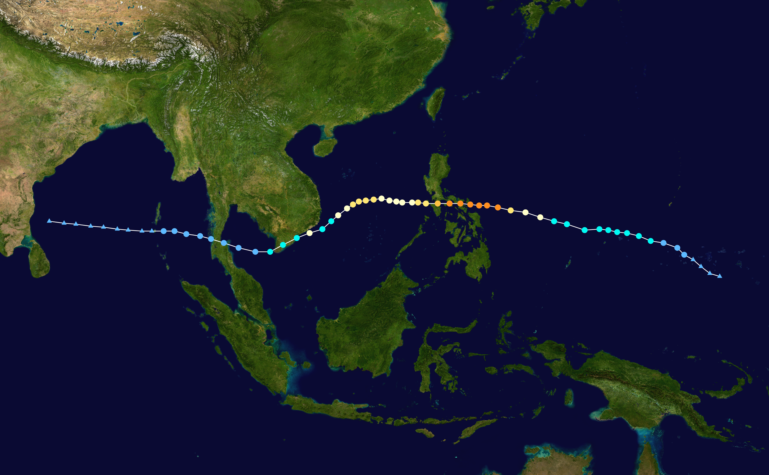
Wikipedia image of the track of typhoon Durian (Reming) in 2006. The orange dots indicate the locations at which the typhoon was at its maximum intensity

NASA image, derived from TRMM data, of the rainfall associated with typhoon Durian (Reming). Note that although 200 mm is very high, far greater rainfall totals are often associated with large typhoons.

Lahars surged down the flanks of Mount Mayon, killing over a thousand people. The film focuses on a comparatively affluent family whose house and land was hit by the lahar. The children's mother was killed, their house destroyed and their land inundated. In the aftermath the government declared the flanks of the volcano to be too hazardous, meaning that the family were moved into a refugee camp. The father of the family is relentlessly cheerful (except when he revisits his house and sees his wife's pillow), but his desperation is clear to see.

The film is available here.

Google Earth image of Mount Mayon, showing a lahar deposit. Click on the image for a full size view in a new window.

In many ways the most interesting aspect is the way that the film balances the hazards associated with the natural processes (i.e. the danger of another event) with the hazards associated with displaced people moving to new settlements that can quickly become slums. It is an interesting film that brings home some fundamental issues in a very real way, without presenting anything terribly new. It is certainly useful for teaching both in schools and at undergraduate level, and as a reminder to those of us working on hazards as to the complexity of the impact of decisions.

UNOSAT image of the impact of Typhoon Reming on Mount Mayon, showing in particular the multiple lahar tracks. Note the degree to which the lahars have impacted upon the towns.