The Mw=7.2 earthquake on the Laguna Salada fault in Mexico on Sunday was certainly sufficiently large and shallow (10 km) to generate landslides, and there are areas of mountains that provide enough relief for slides to develop. To date the number of reports of slides is quite limited, but CNN has this amazing amateur footage of the mountains to the south of Mexicali. The huge dust clouds were almost certainly generated by landslides (see below the fold):
It will certainly be interesting to see what these slides look like on the ground, but given the arid environment shallow rockslides may well be a key component.
Showing posts with label Mexico. Show all posts
Showing posts with label Mexico. Show all posts
Tuesday, April 6, 2010
Monday, October 19, 2009
Latest update on Typhoon Lupit (Typhoon Ramil) and Hurricane Rick
Latest update here
Unfortunately the news on typhoon Lupit (Ramil in the Philippines) is not getting any better. The storm has now turned towards the west and is picking up speed. It is now moving on a bearing of about 300 degrees at about 9 knots (c.17 kmh). This means that it is forecast to start to make landfall on the northern side of Luzon on Wednesday / Thursday. The current forecasts are that it will weaken slightly over the next few days, but this will still be a very strong storm if it does come ashore on Luzon:
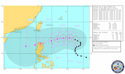 The best hope at the moment is that it takes a more northerly track and shoots through the gap between Taiwan and Luzon. A more northerly track than this could be bad news for Taiwan - this is of course the area that was hit by Morakot (see images here and a review here) in August.
Meanwhile, in the Eastern Pacific Hurricane Rick is now weakening slightly but is heading northwards to make landfall on Baja California, also on Wednesday:
 This storm also has the potential to bring very heavy rainfall, in this case to Mexico, with a very real threat of landslides.
Sunday, January 25, 2009
Two interesting recent landslides
Two interesting landslides to report in the last few days.
1. Landslide in Iztapalapa, Mexico City
On Thursday morning a 50 cubic metre landslide in the Itzapalapa, a poor suburb of Mexico City slid onto a house at the toe of the slope, killing two people. Chinagate has published a rather dramatic picture of the site:
 The interesting thing about this image is the very large (apparently 5 m high) retaining wall that had been built between the slope and the houses. Clearly the wall has failed under the weight of the landslide (not surprising given the size of those boulders actually), but I wonder who built the wall (surely not the people living in these houses - it is far too big)?
2. Landslide-induced wave on Lake Roosevelt, Washington State, USA
The second is a report from the Spokane arm of Lake Roosevelt near to Spokane in Washington State. The website Spokesman Review is carrying a report that says:
"Property owners in the Spokane arm of Lake Roosevelt were swamped by a huge wave caused by a landslide last Friday. The 17-acre landslide on Jan. 16 near Mill Canyon – northeast of Davenport and downstream from Little Falls Dam – slid into the water, unleashing a wave that reached 30 feet above the full-pool mark across the lake into Breezy Bay, according to Adam Kelsey, chief ranger for the Lake Roosevelt National Recreation Area. Private docks and vessels were destroyed or damaged for at least 1.5 miles downstream from the site."
They also have an image of the site:

It is reasonable to assume that the displaced mass on the far side of the lake is the landslide as the Google Earth image does not show a slide at this site:
 It is interesting to note that the section of slope that has failed shows clear signs of toe erosion and some interesting linear features on the Google Earth imagery:
 Interestingly, in the years after Lake Roosevelt was filled there were a series of landslides. The Emergency Management Division of Washington Military Department has a document here that describes a series of events as the lake was filled and emptied:
"1944 to 1953 – Massive landslides generated a number of inland tsunamis in Lake Roosevelt in Eastern Washington:
• April 8, 1944 - A four to five million cubic yard landslide from Reed Terrace generated a 30-foot wave, 5,000 feet away on the opposite shore of the lake about 98 miles above Grand Coulee Dam.
• July 27, 1949 - A two to three million cubic yard landslide near the mouth of Hawk Creek created a 65-foot wave that crossed the lake about 35 miles above Grand Coulee Dam; people 20 miles away observed the wave.
• February 23, 1951 – A 100,000 to 200,000 cubic yard landslide just north of Kettle Falls created a wave that picked up logs at the Harter Lumber Company Mill and flung them through the mill 10 feet above lake level.
• April 10 – 13, 1952 – A 15 million cubic yard landslide three miles below the Kettle Falls Bridge created a 65-foot wave that struck the opposite shore of the lake. People observed some waves six miles up the lake.
• October 13, 1952 – A landslide 98 miles upstream of Grand Coulee Dam created a wave that broke tugboats and barges loose from their moorings at the Lafferty Transportation Company six miles away. It also swept logs and other debris over a large area above lake level.
• February 1953 – A series of landslides about 100 miles upstream from Grand Coulee Dam generated a number of waves that crossed the lake and hit the opposite shore 16 feet above lake level. On average, observed waves crossed
the 5,000-foot wide lake in about 90 seconds.
• April – August 1953 – Landslides originating in Reed Terrace caused waves in the lake at least 11 different times. The largest wave to hit the opposite shore was 65 feet high and observed six miles away. Velocity of one of the series of waves was about 45 miles per hour."
Subscribe to:
Posts (Atom)