The USGS have posted a set of images taken by Randy Jibson and Ed Harp of landslides triggered by the Haiti earthquake earlier this year. The images may be found here:
http://landslides.usgs.gov/learning/photos/international/haiti_earthquake-induced_landslides__january_12__2010
Although the occurrence of landslides was certainly lower than we might have expected, there are some interesting landslides included:
A useful resource and a salient reminder of the threats that the people of Haiti face during this hurricane season.
Showing posts with label landslide images. Show all posts
Monday, August 2, 2010
Friday, June 11, 2010
Two very interesting galleries of recent landslides
I am now trying to catch up on everything that has been pushed aside by the Attabad landslide saga. Whilst all of this has been going on there have been a number of other substantial landslide events. Two of these have impressive galleries of images available, both of which are worth a look:
1. Tropical Cyclone Agatha in Guatemala
The landfall of Tropical Cyclone Agatha on 29th May triggered extensive landslides over a wide area in that country, killing over 150 people. One of the affected areas was the town of San Antonio Palopo. A group of the expatriates have set up a website appealing for assistance (I have no idea as to the legitimacy of this appeal, but also have no reason to disbelieve them). They have put a gallery of images online here. An example of the images is this:
2. Lanckorona, Poland
Meanwhile, the town of Lanckorona in Poland is being slowly destroyed by a large, slow moving landslide, with terrible consequences for the inhabitants. At the time of writing, a second phase of movements has been reported. There is a couple of decent videos of the town here, but most impressive (and dreadful) is the extensive gallery of images here, including these two:
Both sets of images are worth a look
The continued threat posed by landslides at Attabad
Attention continues to be focused upon the state of the spillway at Attabad, and in particular the likely impact of the increase in flow we might see over the next few weeks. Yesterday's images from Focus showed that slow evolution of the spillway continues, with the lake level reported to have dropped only by a:n inch (2.5 cm):
However, we must not lose sight of the potential for other failure mechanisms. Given that seepage appears to now be constant, the greatest concern may well be associated with the potential for a further landslide into the lake. The high water levels and (comparatively) warm temperatures render this a possibility (but not in any way a probable event). This remarkable set of images, taken at 6:14 to 6:16 pm last night (10th June) by the Focus geologists, clearly illustrates the ongoing threat:
Friday, March 5, 2010
The Attabad landslide in N. Pakistan - some initial images from my field visit this week
I am now back from my comparatively short but very interesting trip to the 
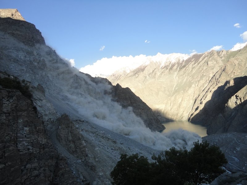
Attabad landslide in N. Pakistan. I will make a series of posts about this serious but very interesting landslide over the next few days. As a taster, here a few images of the site. The first image was taken from the top of the 1858 Salmanabad landslide deposit, looking upstream to the Attabad slide. The scar of the landslide is on the left and extends beyond the snowline. The main landslide deposit is on the right, coated with a layer of black clay-silt sediment that was scooped up from the river bed by the slide. In the valley bottom the secondary flow is also visible - this was a mudflow of riverbed sediment that travelled about 1.5 km. Look carefully on the full image (click on the image below to see this) and you will see the ruins of some buildings on the left side of the mudflow, at the junction with the rock cliff. This is the place where the 19 victims of the landslide died, struck by the mudflow:
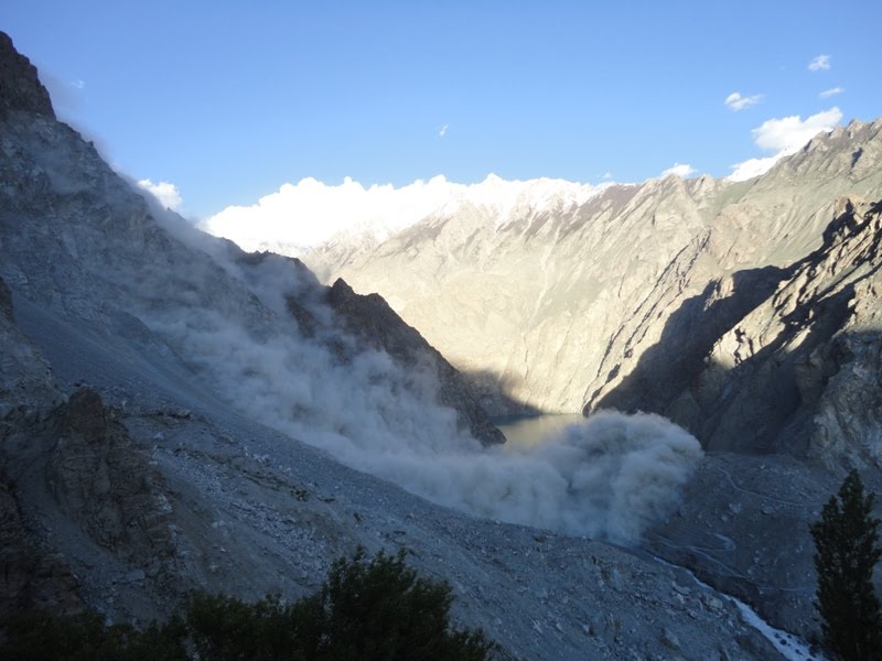
The image below shows the spillway under construction. At the moment the spillway is still being excavated in the black mudflow deposit, although this will shortly break through to the underlying colluvium. The army are optimistic that the spillway will survive the summer flood - others may have a different opinion...
This final image is a view from the top of the landslide deposit looking upstream. In the foreground is the landslide deposit - note the lack of black clay here. In the background is the lake and, beyond that, the rock walls of the main river valley. If the landslide does survive then a new section of the Karakoram Highway will need to be built through this section. This will take some time.
More to follow.

Friday, January 1, 2010
Latest updates on the Brazil landslides
Latest update (3rd Jan 22:40 UT) here
Updated 22:47 UT with revised fatality count
Updated with an additional photo
Globo now has a more detailed report with images of the landslides today in Brazil that I covered in an earlier post.
1. The landslide at pousada Sankay (Sankai) in Praia do Bananal, Ilha Grande

Nineteen (Nb updated from 14) bodies have now been found at the site of the lodge and in the sea around. The images of the site show a shallow slide at the interface between the regolith and bedrock. Five people have been rescued alive.
Update: Sky News has this additional image, which shows that the slide is much larger than the image above suggests:

2. The landslide at Morro da Carioca, Angra dos Reis
This landslide is believed to have killed ten (updated from five) people. There must be real concern about the other houses located at the toe of this slope, which appears to have signs of distress in other locations in addition to the new landslide.
3. Other landslides
Sadly, the three year old girl rescued from the landslide in Cascadura, a suburb of Rio de Janeiro, yesterday, has died. This brings the toll from this period of heavy rainfall to 39.
Updated 22:47 UT with revised fatality count
Updated with an additional photo
Globo now has a more detailed report with images of the landslides today in Brazil that I covered in an earlier post.
1. The landslide at pousada Sankay (Sankai) in Praia do Bananal, Ilha Grande

Nineteen (Nb updated from 14) bodies have now been found at the site of the lodge and in the sea around. The images of the site show a shallow slide at the interface between the regolith and bedrock. Five people have been rescued alive.
Update: Sky News has this additional image, which shows that the slide is much larger than the image above suggests:

2. The landslide at Morro da Carioca, Angra dos Reis

3. Other landslides
Sadly, the three year old girl rescued from the landslide in Cascadura, a suburb of Rio de Janeiro, yesterday, has died. This brings the toll from this period of heavy rainfall to 39.
Wednesday, November 25, 2009
A follow up to the Tennessee landslide video
A couple of weeks ago I highlighted a new landslide video from Highway 64 in Tennessee, USA. Thanks to the excellent GeoPracNet for highlighting that some aerial imagery is now available from News Channel 9 of the slide:
The sliding plane was clearly an existing discontinuity sub-parallel to the slope, with movement perhaps being allowed by the cutting of the slope to create the road bench.
Monday, October 19, 2009
Typhoon Parma (Pepeng) - some interesting images
Thanks to Dr Deirdre McKay from Keele University for highlighting these images to me.
Inan Lanoi has an album of photographs taken in the aftermath of Typhoon Parma (Pepeng) in the Philippines. Whilst perhaps less polished than the images that one gets on news sites, they capture very well the true impact of the landslides. The images can be viewed on Inan's Facebook page here (you need a Facebook account to view this album).
I have taken the liberty to reproduce a couple of images here, primarily because I want to keep this event at the forefront of our minds, given the impending threat from Typhoon Lupit. This is the landslide at Kayan, Tadian, which reportedly killed 35 people:


Thursday, October 15, 2009
Typhoon Parma - interesting image
I have today come across this dramatic image of the aftermath of the landslides triggered by typhoon Parma (Pepeng) in the Philippines (source GMA News.TV):

Sunday, September 13, 2009
A small collection of interesting landslide images
A quick post today - I thought I'd post a small selection of impressive landslide images that I have come across recently:

Landslides resulting from deforestation in Taraza, Antioquia, Colombia, from here.
A long runout landslide from Sichuan in China, from here.
After effects of a landslide on the island of Ibiza in Spain, from here.


Subscribe to:
Posts (Atom)