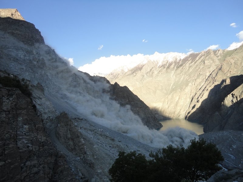
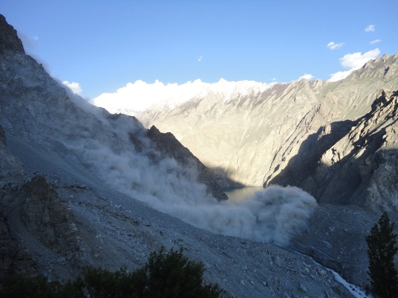
Attention continues to be focused upon the state of the spillway at Attabad, and in particular the likely impact of the increase in flow we might see over the next few weeks. Yesterday's images from Focus showed that slow evolution of the spillway continues, with the lake level reported to have dropped only by a:n inch (2.5 cm):
However, we must not lose sight of the potential for other failure mechanisms. Given that seepage appears to now be constant, the greatest concern may well be associated with the potential for a further landslide into the lake. The high water levels and (comparatively) warm temperatures render this a possibility (but not in any way a probable event). This remarkable set of images, taken at 6:14 to 6:16 pm last night (10th June) by the Focus geologists, clearly illustrates the ongoing threat:
Friday, June 11, 2010
Wednesday, June 9, 2010
Attabad spillway video
Thanks to a number of people for drawing my attention to the Hunzaonline video on youtube that shows the spillway in action. The caption indicates that this was collected on the 8th June:
Three observations about this video:
In case anyone was wondering, that expert is not me! Whilst I wouldn't completely rule out the possibility of a controlled blast, this would need to be undertaken with extreme care, and only after a full analysis of the consequences had been undertaken. I would in particular want to see an evaluation of the likely flood that the blast might trigger, and the potential for triggering further slides on the sides of the valley. However, this is not an excuse for inaction - NDMA really need to move quickly now to evaluate the range of options, and to communicate the pros and cons more widely.
As per my post yesterday, I will use the Hunza Monitoring Site to host updates on the situation at Attabad, and this site to provide a commentary. I will put a new set of data on the monitoring blog later this morning.
Three observations about this video:
- It shows that the major restriction on flow is still the large boulder at the saddle of the spillway;
- A second boulder has formed substantive constriction downstream as well, but this is not controlling the overall flow
- There is still considerable scour occurring, especially on the downstream side of the boulder, upstream of the boulder towards the neck of the channel, and elsewhere on the banks of the channel.
In case anyone was wondering, that expert is not me! Whilst I wouldn't completely rule out the possibility of a controlled blast, this would need to be undertaken with extreme care, and only after a full analysis of the consequences had been undertaken. I would in particular want to see an evaluation of the likely flood that the blast might trigger, and the potential for triggering further slides on the sides of the valley. However, this is not an excuse for inaction - NDMA really need to move quickly now to evaluate the range of options, and to communicate the pros and cons more widely.
As per my post yesterday, I will use the Hunza Monitoring Site to host updates on the situation at Attabad, and this site to provide a commentary. I will put a new set of data on the monitoring blog later this morning.
Tuesday, June 8, 2010
Slowing evolution of the spillway at Attabad
Once again I am grateful for Focus Humanitarian Assistance for sending the latest photos of the spillway at Attabad. The rate of change new seems to be slowing as flow is being controlled by the large boulders at the head of the channel. This pair show the downslope side of the channel - the left hand image was taken on 7th June and the right hand image a day later:
Allowing for the slight change in camera angle, there is little indication of major change between the two images. The large boulder on the left side of the upper part of the channel bank has slipped into the water on the right hand image, presumably indicating that channel widening is continuing. Of course there may well be some continued erosion of the bed that would is not visible here.
In the upper channel there is comparably little evidence of change also. The inset image is from 7th June, the main image a day later:
It may be that a more detailed inspection on the ground would reveal a more dynamic system.
It is my intention to stop duplicating posts on the two sites from today, with the Hunza Monitoring Blog being used once again to present data on the state of the dam and the lake, and Dave's Landslide Blog to provide a commentary. On DLB I will also start covering other landslide events again.
Allowing for the slight change in camera angle, there is little indication of major change between the two images. The large boulder on the left side of the upper part of the channel bank has slipped into the water on the right hand image, presumably indicating that channel widening is continuing. Of course there may well be some continued erosion of the bed that would is not visible here.
In the upper channel there is comparably little evidence of change also. The inset image is from 7th June, the main image a day later:
It may be that a more detailed inspection on the ground would reveal a more dynamic system.
It is my intention to stop duplicating posts on the two sites from today, with the Hunza Monitoring Blog being used once again to present data on the state of the dam and the lake, and Dave's Landslide Blog to provide a commentary. On DLB I will also start covering other landslide events again.
Monday, June 7, 2010
Latest image of the spillway at Attabad
The wonderful people at Focus have provided an image of the state of the spillway at Attabad that is very instructive. This was taken today:
The current state of play is I think as follows. Flow appears to be constrained by two blockages but, as a commenter has noted, one is a rock spur out of the channel. The blockage appears to have formed a small waterfall / rapid. Downstream of the blockage the channel has widened dramatically - and indeed a section of the track has now been lost.
To me this suggests that the crisis may be far from being over. In particular, the loss of this barrier could cause a rapid increase in flow rate that could be highly erosive. It is however important to stress that interpreting the state of play from photos is difficult.
The current state of play is I think as follows. Flow appears to be constrained by two blockages but, as a commenter has noted, one is a rock spur out of the channel. The blockage appears to have formed a small waterfall / rapid. Downstream of the blockage the channel has widened dramatically - and indeed a section of the track has now been lost.
To me this suggests that the crisis may be far from being over. In particular, the loss of this barrier could cause a rapid increase in flow rate that could be highly erosive. It is however important to stress that interpreting the state of play from photos is difficult.
Sunday, June 6, 2010
Attabad - an increasingly difficult hazard to manage
Apologies to all who emailed and left messages over the weekend requesting updates.
FWO data collected at 8 am on Saturday suggests that the rate of flow was 124.6 cumecs, whilst the Pamir Times reported yesterday that it was 131.7 cumecs. If so, the discharge time graph looks like this:
Thus, the discharge is apparently stabilising. Various media reports from the site itself suggest that downward erosion of the channel has now reduced, but that some lateral erosion is still occurring. I have not seen any images to confirm this though. The lake has stopped rising for now.
It is hard from here to assess the current position with regards to the dam, or to forecast what will happen next. However, from the start I have held the view that managing this hazard would be somewhat challenging if stable flow became established. The chronic hazard has not gone away, although the acute hazard may have reduced. As there is still a vast quantity of water stored in the landscape, the dam remains vulnerable to a series of processes, including:
Meanwhile, of course those on the upstream side remain isolated, with a huge lake impeding access. The Karakoram Highway remains closed indefinitely, although the boat service has been resumed. During summer floods, when inflow may briefly exceed outflow, the lake level could rise again by a small amount, unless progressive erosion of the spillway serves to lower the lake level. Thus, overall, many challenges remain at Attabad.; it will be interesting to see how NDMA responds to them.
FWO data collected at 8 am on Saturday suggests that the rate of flow was 124.6 cumecs, whilst the Pamir Times reported yesterday that it was 131.7 cumecs. If so, the discharge time graph looks like this:
Thus, the discharge is apparently stabilising. Various media reports from the site itself suggest that downward erosion of the channel has now reduced, but that some lateral erosion is still occurring. I have not seen any images to confirm this though. The lake has stopped rising for now.
It is hard from here to assess the current position with regards to the dam, or to forecast what will happen next. However, from the start I have held the view that managing this hazard would be somewhat challenging if stable flow became established. The chronic hazard has not gone away, although the acute hazard may have reduced. As there is still a vast quantity of water stored in the landscape, the dam remains vulnerable to a series of processes, including:
- An unexpected increase in erosion rate;
- Erosion during flood events (the discharge of the Hunza will rise substantially in the next few weeks);
- A further landslide on the banks of the lake, which could trigger a wave;
- A seismic event.
Meanwhile, of course those on the upstream side remain isolated, with a huge lake impeding access. The Karakoram Highway remains closed indefinitely, although the boat service has been resumed. During summer floods, when inflow may briefly exceed outflow, the lake level could rise again by a small amount, unless progressive erosion of the spillway serves to lower the lake level. Thus, overall, many challenges remain at Attabad.; it will be interesting to see how NDMA responds to them.
Friday, June 4, 2010
Attabad: spillway flow update of 08:30 this morning
There is a mass of confusing and contradictory information about the state of flow in the Attabad spillway, but the FWO data appears to be consistent at the moment. The latest data, again via Dr Sadiq, is that flow was 3700 cusecs (105 cumecs) at 08:00 local time this morning. This makes the graph look like this:
This suggests that we are still seeing an incremental increase in flow. However, interestingly, the rate of inflow and the rate of outflow now appear to be balanced, such that the lake level should stop rising (for a while anyway). If this happens, and spillway flow continues to increase, we will know that erosion is developing.
Photos of the development of the situation at Attabad
Focus have kindly provided a new set of images of the situation at Attabad with respect to the spillway. I think that these images were taken yesterday.
Most importantly, here is an overview image of the spillway:
It is helpful to compare this with the image of the spillway from 1st June (right hand image):
It is clear that the situation has developed considerably over the last few days. The flow along the spillway has increased greatly, and the lower part of the channel has widened and deepened. Flow appears to still be controlled by the large boulder in the middle of the channel, although the lowering of the channel downstream will be steadily undercutting this.The development of the spring on the channel edge is also interesting.
A closer view of the spillway clearly shows how widening is occurring:
The flow is undercutting the banks, which are then progressively failing. Note also just how much scour is occurring even though the bed of the channel is boulder-strewn - it is clear that at the moment the boulders are not armouring the channel.
A view from the downstream side of the channel is fairly dramatic:
This gives the impression that there is a huge volume of water flowing. However, a look downstream towards the old landslide deposit at Salmanabad (that is the big pile of debris upper right) shows that this is not really the case:
It is clear that the flow is still rather modest, despite the huge amount of erosion that the water has achieved.
Most importantly, here is an overview image of the spillway:
It is helpful to compare this with the image of the spillway from 1st June (right hand image):
It is clear that the situation has developed considerably over the last few days. The flow along the spillway has increased greatly, and the lower part of the channel has widened and deepened. Flow appears to still be controlled by the large boulder in the middle of the channel, although the lowering of the channel downstream will be steadily undercutting this.The development of the spring on the channel edge is also interesting.
A closer view of the spillway clearly shows how widening is occurring:
The flow is undercutting the banks, which are then progressively failing. Note also just how much scour is occurring even though the bed of the channel is boulder-strewn - it is clear that at the moment the boulders are not armouring the channel.
A view from the downstream side of the channel is fairly dramatic:
This gives the impression that there is a huge volume of water flowing. However, a look downstream towards the old landslide deposit at Salmanabad (that is the big pile of debris upper right) shows that this is not really the case:
It is clear that the flow is still rather modest, despite the huge amount of erosion that the water has achieved.
Subscribe to:
Posts (Atom)