 Given this volume of water it is likely that this is flow through the dam, although at the moment this remains unconfirmed. If so, this is a source of real concern as landslide dams sometimes fail through piping. Fortunately, both Focus and NDMA are monitoring this, but there is now a real urgency about getting an evacuation plan in place. This situation could now develop much more rapidly than we had anticipated a week ago.
Thursday, March 11, 2010
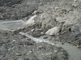
The landslide at Attabad has developed seepage
Late last week the landslide at Attabad started to develop some seepage. Over the last few days this has gradually increased in rate and is now measured at about 9.4 cubic feet per second (0.25 cubic metres per second). The Pamir Times has some images of the seepage:
 Given this volume of water it is likely that this is flow through the dam, although at the moment this remains unconfirmed. If so, this is a source of real concern as landslide dams sometimes fail through piping. Fortunately, both Focus and NDMA are monitoring this, but there is now a real urgency about getting an evacuation plan in place. This situation could now develop much more rapidly than we had anticipated a week ago.
Given this volume of water it is likely that this is flow through the dam, although at the moment this remains unconfirmed. If so, this is a source of real concern as landslide dams sometimes fail through piping. Fortunately, both Focus and NDMA are monitoring this, but there is now a real urgency about getting an evacuation plan in place. This situation could now develop much more rapidly than we had anticipated a week ago.
Subscribe to:
Post Comments (Atom)
"If so, this is a source of real concern as landslide dams sometimes fail through piping."
ReplyDeleteDave-
Could you discuss the soil composition versus failures, including rates? I am guessing if a dam were fine grained, such as sand, it would not take much flow to destabilize the structure. On the other hand, I would guess that large boulders that are locked together and filled with a bit of clay would have a greater chance of survival.
We have seen from the video that the top is fine grained soils. Is a minor failure likely as the water rises toward the fine grained soils?
Another thing I have been trying to figure out is the amount of pressure that is being placed on the dam. It's too bad that there wasn't a 300' waterfall just before the dam, as that would significantly limit the quantity of water that the dam would hold. In this case it appears that the river gradients are not that large, and that the valley is fairly wide, so the lake that is forming is quite large.
Given the height of the landslide dam, how much water will be held back at the point when the water starts to spill over the dam? (Yes, make all the nice assumptions, such as the dam does not fail, that there is a bit of lowering of the height by human efforts, another landslide does not significantly increase the height, and so on.)
Finally, is there any other option for protection against a sudden failure (a major failure in less than a day, or maybe a week, for example). What measures might be prudent and practical for those downstream to take, other than evacuation plans.
Thanks for the continued coverage.
Dave,
ReplyDeleteIt would be of interest to know whether or not the hydraulic discharge shown in the photo occurred in the spillway channel excavation.
My following comment can only be very subjective and based on a much simplified situation.
The spillway channel excavation is clearly a potentially vulnerable area for through seepage discharge from the dam. It would tend to act like a 'sink' towards which any seepage within range would flow.
As the distance between the excavation and the dam/lake interface reduces so the length of the seepage flowpaths also reduce. Consequently both the hydraulic gradients and thereby the seepage velocities increase.
The obvious danger would be that the exit hydraulic gradients, at the points where the seepage discharges into the excavation have increased to the critical value whereby piping is initiated, leading to failure of the dam.
Given the apparently fine material comprising much of the dam, the problem would be to ensure that any seepage hydraulic gradients within the dam are controlled: difficult to do in a naturally created dam.
It would seem that if the spillway channel was formed having a broad (in the upstream/downstream direction)fairly level invert profile, forming a section of dam crest, sufficiently long flowpaths in the dam would occur dissipating the differential hydraulic head driving the seepage.
Downward excavation of the crest would require a broad crest to be maintained.
Obviously, for the actual situation relating to the site, an appropriate seepage analysis/assessment would be required.
An interesting problem when distant from the reality of it and the difficulties presented are well understood, but it hoped that it is safely resolved for those directly affected by the situation.
Fantastic NASA Earth Observtory image of the landslide lake here http://earthobservatory.nasa.gov/IOTD/view.php?id=43105
ReplyDeleteYour blog gets a namecheck in the refs. Congratulations!