Whilst this is not strictly a landslide, the video below of the failure of a culvert makes very interesting viewing. The ability of the channelled water to erode rapidly is a lesson that is often forgotten.
The video was captured by MWTW.com photojournalist Kevyn Fowler in Freeport, Maine during a storm.
Showing posts with label erosion. Show all posts
Showing posts with label erosion. Show all posts
Sunday, May 17, 2009

Monday, February 9, 2009
Australian wildfires and risks of increased erosion rates
 (Updated 10th Feb to include latest casualty numbers)
The extraordinary wildfires in Australia are dominating the headlines in the UK, half a world away. Wildfires are quite common events, but the number of fatalities that this particular episode has caused is really quite unusual. Below in Figure 1 I have plotted the recorded worldwide recorded number of deaths from wildfires for the period since 1980, using data from the CRED EM-DAT database . I have added the (updated to) 173 reported deaths from this event so far as an extra column, although note that reports suggest that this total may rise substantially:
 Figure 1: Global numbers of reported fatalities from widlfires, based upon the CRED EM-DAT database. The 2009 value is the reported number of deaths from the Austrlian wildfires.
The average annual global total number of deaths is 59.5 fatalities per annum. Care is needed in the interpretation of the above as CRED only record events that kill ten or more people, thus these values consistently underestimate the true toll, but nonetheless the unusual impact of these events is clear.
In the context of this blog it is also interesting to think through the likely long term impact of these fires in terms of erosion and landslides. A recent paper by Smith and Dragovitch (2008) looked at the long term consequences of wildfires in SE. Australia. These two researchers have published extensively on sediment production and erosion in Australia, so have a strong pedigree.
The study focused on a fire that occurred in January 2003 during a drought in the Snowy Mountains near to Thredbo (Fig. 2), a sub-alpine environment. The study used erosion pins to monitor surface level change on both burnt and unburnt hillslopes over a period of 795 days after the fire.

Figure 2: Google Earth perspective image of the area around Thredbo, the location of the study reported by Smith and Dragovich (2008)
The study showed that after the fire the areas that had been burnt suffered a net loss of soil representing an average of 3.8 mm of material, with the most intense erosion occurring on the lower slopes (Fig. 3). On the other hand, the unburnt areas saw a net accumulation of soil of an average of 2.6 mm, again with the greatest accumulation at the lower slopes.
 Figure 3: Mean net soil loss and gain for burnt and unburnt areas as reported by Smith and Dragovich (2008).
Thus, the burnt areas clearly suffered a net loss of material in the aftermath of the fires. The study showed that this loss of soil declined with time after the fire, with a slight increase again during snow melt, presumably as vegetation re-established. However, these values are perhaps surprisingly low compared with those recorded in other environments, especially in N. America, given the steep slope angles seen in Figure 2. Interestingly, Shakesby et al. (2007), who studied post-fire erosion in Eucalyptus forests in SE. Australia, came to similar conclusions, stating that "except under extreme post-fire rainfall conditions, present-day wildfires affecting south-east Australia seem to be less potent in geomorphological terms than might be expected given the severity and frequency of the wildfires". They attribute this to the rapid rate of plant growth in the aftermath of fires plus the resistance of the soil to erosion.
The conclusion is therefore that although the fires have devastated vast areas, and made thousands homeless, there should not be a serious increase in erosion in the burnt areas. This will help greatly in the post-fire recovery of the burnt areas.
References:
H SMITH, D DRAGOVICH (2008). Post-fire hillslope erosion response in a sub-alpine environment, south-eastern Australia CATENA, 73 (3), 274-285 DOI: 10.1016/j.catena.2007.11.003
R SHAKESBY, P WALLBRINK, S DOERR, P ENGLISH, C CHAFER, G HUMPHREYS, W BLAKE, K TOMKINS (2007). Distinctiveness of wildfire effects on soil erosion in south-east Australian eucalypt forests assessed in a global context Forest Ecology and Management, 238 (1-3), 347-364 DOI: 10.1016/j.foreco.2006.10.029
Friday, January 2, 2009
Evaluating coastal erosion using art
The BBC is carrying a quite interesting story at the moment about the use of artwork from the nineteenth century to evaluate rates of coastal erosion. The story originates from Robin McInnes, who is an established figure in coastal management. Robin was the Coastal Manager for the Isle of Wight, in southern England for many years, during which he led the way in terms of developing an understanding and management of coastal erosion. This ended somewhat abruptly a couple of years ago. Fortunately, Robin is clearly still active in an independent capacity.
The work has been written up in a short but useful report that is available here. There was also a New Scientist article that featured this approach in the middle of last year.
The Isle of Wight is well known as a zone of active coastal erosion, most notably as a result of a series of large landslides along the southern coast, including probably one of the earliest events captured on camera:
 Fortunately, the south coast of the Isle of Wight is also both beautiful and accessible. It was a particularly fashionable tourist destination of the rich and famous in Victorian (mid to late 19th century) times, which meant that it was also frequently captured in artwork. Robin McInnes has amassed over 400 pieces of artwork from the period 1770 onwards. He has graded the quality of depiction of each artist in order to determine which provides a representation that is sufficiently reliable to be usable today. McInnes suggests that good quality depictions can be used to:

The image below is a photograph from the 1890's of Steephill Cove in Ventnor (from here):

Here is a photograph of Steephill Cove from 1906 (from here):

And finally, here is a modern day image (from here):

The work has been written up in a short but useful report that is available here. There was also a New Scientist article that featured this approach in the middle of last year.
The Isle of Wight is well known as a zone of active coastal erosion, most notably as a result of a series of large landslides along the southern coast, including probably one of the earliest events captured on camera:
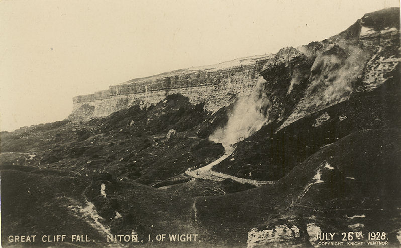 Fortunately, the south coast of the Isle of Wight is also both beautiful and accessible. It was a particularly fashionable tourist destination of the rich and famous in Victorian (mid to late 19th century) times, which meant that it was also frequently captured in artwork. Robin McInnes has amassed over 400 pieces of artwork from the period 1770 onwards. He has graded the quality of depiction of each artist in order to determine which provides a representation that is sufficiently reliable to be usable today. McInnes suggests that good quality depictions can be used to:
- Understand geological structure and form (especially where the artists depicted a landscape that has now been built over or forested);
- Examine changes in geomorphological structures or processes;
- Determine changes in beach geometries;
- Compare changes in coastal morphology due to erosion;
- Provide a chronology of coastal defences;
- Establish the evolution of estuaries and harbours;
- Provide an insight into habitat change.

The image below is a photograph from the 1890's of Steephill Cove in Ventnor (from here):

Here is a photograph of Steephill Cove from 1906 (from here):

And finally, here is a modern day image (from here):

Sunday, October 19, 2008
A strange report from Nigeria...
The Nigerian newspaper "The Punch" has been carrying a quite strange and intriguing story over the last few days regarding an apparently huge landslide in the Awgu area (i.e. at about 6.0046N, 7.4024E). The key points of the story (from the Punch) are:
"Residents of Ugwueme, Umuhu, Ugulesi Awgu and Ezinese Mgbidi communities in Awgu Local Government Area, Enugu State could not believe their eyes when they visited their farmland in the morning. Expansive farmlands measuring more than 20 square kilometres had been destroyed by a tremor. On account of the incident which was later explained as a landslide, there were huge cracks and depressions on the land as if a straying ballistic missile had exploded there. Some trees sank in the depression while others were completely uprooted."
The traditional Prime Minister of Awgu, Chief Stephen Onuorah, who visited the scene on the second day of the incident, said he felt a massive shaking and reverberations under his feet. He said he heard a noise that sounded like the roaring of a bulldozer. Surmising that it was an earthquake, he contacted the Chairman of Awgu Local Government Area, Chief Uche Anioke, who later led some officials to the site. Amazed at the level of devastation, the council boss contacted experts from the Federal Ministry of Mines and Steel Development, but the confusion over the incident was dispelled by the team of experts from the National Geo-hazards Monitoring Centre led by the director of the agency, Mr. Alex Nwegbu, and Prof Cornelius Nwajide, a lecturer at the University of Nigeria, Nsukka and consultant to Shell Petroleum Development Corporation.
"Residents of Ugwueme, Umuhu, Ugulesi Awgu and Ezinese Mgbidi communities in Awgu Local Government Area, Enugu State could not believe their eyes when they visited their farmland in the morning. Expansive farmlands measuring more than 20 square kilometres had been destroyed by a tremor. On account of the incident which was later explained as a landslide, there were huge cracks and depressions on the land as if a straying ballistic missile had exploded there. Some trees sank in the depression while others were completely uprooted."
The traditional Prime Minister of Awgu, Chief Stephen Onuorah, who visited the scene on the second day of the incident, said he felt a massive shaking and reverberations under his feet. He said he heard a noise that sounded like the roaring of a bulldozer. Surmising that it was an earthquake, he contacted the Chairman of Awgu Local Government Area, Chief Uche Anioke, who later led some officials to the site. Amazed at the level of devastation, the council boss contacted experts from the Federal Ministry of Mines and Steel Development, but the confusion over the incident was dispelled by the team of experts from the National Geo-hazards Monitoring Centre led by the director of the agency, Mr. Alex Nwegbu, and Prof Cornelius Nwajide, a lecturer at the University of Nigeria, Nsukka and consultant to Shell Petroleum Development Corporation.
The team which also included geologists, geophysicists and seismists, visited the farmland on Tuesday. They described the incident as a landslide which occurred on account of massive rainfall which “peculated into the land to an impermeable layer and caused land cracks”. Nwegbu in his preliminary report traced the remote cause of the incident to the geographical positioning of Awgu which was sitting on a ridge belt called clay star. The belt runs from Idah in Kogi State through Awgu to Arochukwu community in Cross River State, all of which are prone to geo-hazards.
The Chairman of the House Committee on Petroleum Resources and Environmental Management, Chris Ugwu, in a report sent to the state assembly, described the incident as an unusual disaster...Ugwu said that his committee, which visited the area, observed that large portions of land were compressed into crooked ridges and valleys."
This is intriguing because the area affected appears to be very large (>20 square kilometres) and the level of destruction appears to be high, even though the landslide has not been catastrophic in terms of movement. The terrain is question is not particularly steep or rugged, and this is not an area with notable seismicity. I would be very interested to hear more about this slide. I wonder whether this earlier report, although possibly covering a different area, might provide an indication of the root cause of the issue?
Although Nanka has bared the brunt of the erosion-based devastations, it has however not been relegated only to Nanka. Other towns have been faced with their unfortunate share of these hellish gullies. Enugu Ukwu is another town ravished by gully erosion. According to a 1993 State report on the state of gully erosions in Anambra, “the number of gullies presently pervading and ravaging the lands of Enugu Ukwu defies solution”. The story of the gullies in Enugu Ukwu begins with the Etti-Umuatulu-Osili Enugu Ukwu gully networks which starts from Etti Awobu village and gallops down a slope stretching down into Umuatulu Awobu where it splits into two branches; to run into Obuagu Osili where it converges to a point where the gully depth stands at about 80meters. The gully network within the Urukpaleke and Akama Osili areas originate which is reported to have been aggravated by a flood from a faulty drainage line constructed along Enugu-Onitsha road. The same gully stretches to another Akama Osili village and joins Urukpaleke gully. According to Inter Press Service New Agency who was one of the many New Agencies that reported on the incident, “the inhabitants of Umuchiana, one of the villages that make up Ekwulobia community in Anambra state, were woken up at night by a noise only to find some houses at the edge of the village giving way to landslide. They deserted their homes, taking refuge in nearby forest and villages. By the time they returned to their village the following morning, several houses, a church and some roads were washed away. Their farmlands, palm and cashew trees were not spared either. Though nobody died in the incident, more than 250 families (made up of more than 1,500 persons) were displaced.
Subscribe to:
Posts (Atom)