On Friday I gave a public lecture at the Badbury Centre in North Yorkshire (NE England), looking at the potential impacts of climate change on coastal erosion. The presentation was focused on the field site that we maintain at Boulby, close to the lecture venue. In the presentation I start by looking at our landslide database and then go on to talk about climate change. The main part of the presentation is an examination of the likely impact of climate change, looking at the ways in which potential erosion rates have been determined, and then using our own very high resolution work to examine how this can be done properly. I hope that in the presentation I show that in this area at least the impacts of climate change on erosion are not as great as some might fear, and that proper scientific analysis allows one to develop proper models of future impacts.
I must stress here that this does not suggest that climate change is not a real and urgent problem - it is - and in the talk and in the questions afterwards I stressed the vital importance of a successful outcome to the Copenhagen talks.
The presentation is available via Authorstream below:
My personal Authorstream page, which contains a selection of my recent presentations, is available here:
www.authorstream.com/user-presentations/Dr_Dave/
Showing posts with label cliff. Show all posts
Showing posts with label cliff. Show all posts
Sunday, November 8, 2009
Friday, September 18, 2009
Extraordinary! Using a helicopter sledgehammer to clear loose rock from a cliff!

I thought I had seen everything until I saw this video! It is from Norway, showing an extraordinary method for removing a loose rock pillar from a high, steep cliff. The answer is obvious - just hang a 1.8 tonne block on a cable under the helicopter and bash the offending rock with your new sledgehammer. This must take very skillful flying. The most amazing thing is that it worked - and there is some good footage of the not - insubstantial block descending the cliff.

I really strongly advise that you take look! It is on the following Norwegian news site:
http://www.adressa.no/tv/?id=11756
Friday, January 2, 2009
Evaluating coastal erosion using art
The BBC is carrying a quite interesting story at the moment about the use of artwork from the nineteenth century to evaluate rates of coastal erosion. The story originates from Robin McInnes, who is an established figure in coastal management. Robin was the Coastal Manager for the Isle of Wight, in southern England for many years, during which he led the way in terms of developing an understanding and management of coastal erosion. This ended somewhat abruptly a couple of years ago. Fortunately, Robin is clearly still active in an independent capacity.
The work has been written up in a short but useful report that is available here. There was also a New Scientist article that featured this approach in the middle of last year.
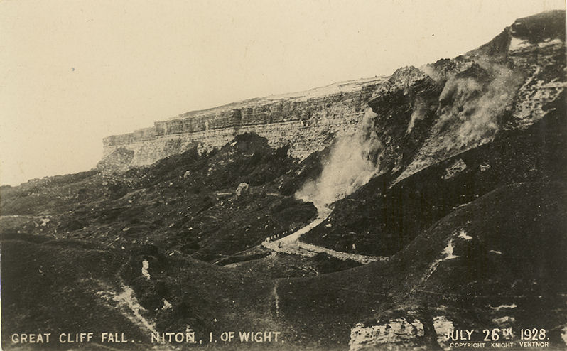
The Isle of Wight is well known as a zone of active coastal erosion, most notably as a result of a series of large landslides along the southern coast, including probably one of the earliest events captured on camera:
 Fortunately, the south coast of the Isle of Wight is also both beautiful and accessible. It was a particularly fashionable tourist destination of the rich and famous in Victorian (mid to late 19th century) times, which meant that it was also frequently captured in artwork. Robin McInnes has amassed over 400 pieces of artwork from the period 1770 onwards. He has graded the quality of depiction of each artist in order to determine which provides a representation that is sufficiently reliable to be usable today. McInnes suggests that good quality depictions can be used to:

The image below is a photograph from the 1890's of Steephill Cove in Ventnor (from here):

Here is a photograph of Steephill Cove from 1906 (from here):

And finally, here is a modern day image (from here):

The work has been written up in a short but useful report that is available here. There was also a New Scientist article that featured this approach in the middle of last year.
The Isle of Wight is well known as a zone of active coastal erosion, most notably as a result of a series of large landslides along the southern coast, including probably one of the earliest events captured on camera:
 Fortunately, the south coast of the Isle of Wight is also both beautiful and accessible. It was a particularly fashionable tourist destination of the rich and famous in Victorian (mid to late 19th century) times, which meant that it was also frequently captured in artwork. Robin McInnes has amassed over 400 pieces of artwork from the period 1770 onwards. He has graded the quality of depiction of each artist in order to determine which provides a representation that is sufficiently reliable to be usable today. McInnes suggests that good quality depictions can be used to:
- Understand geological structure and form (especially where the artists depicted a landscape that has now been built over or forested);
- Examine changes in geomorphological structures or processes;
- Determine changes in beach geometries;
- Compare changes in coastal morphology due to erosion;
- Provide a chronology of coastal defences;
- Establish the evolution of estuaries and harbours;
- Provide an insight into habitat change.

The image below is a photograph from the 1890's of Steephill Cove in Ventnor (from here):

Here is a photograph of Steephill Cove from 1906 (from here):

And finally, here is a modern day image (from here):

Subscribe to:
Posts (Atom)