Thanks to my former student Kurtis Garbutt for the heads up on this one. The video below shows the progressive development of a road in Thailand. I suspect that this initiated as a culvert failure, with multiple collapses due to undercutting:
The final frames of the video show an overview of the site. Check out where the people are standing!
As an aside, Kurtis also runs a very interesting blog on natural hazards - take a look. It is a very useful resource with a scope that goes way beyond my site.
Showing posts with label road. Show all posts
Showing posts with label road. Show all posts
Tuesday, September 14, 2010
Sunday, April 25, 2010
A huge landslide on Freeway No.3 in Taiwan
Taiwan today suffered an extraordinary landslide in Highway number 3, which links Taipei with Keelung. The landslide appears to have completely buried the road for a distance of about 300 m. The depth of burial looks to be more than 10 m. There are reports that there were a number of cars on the road at the time - if so, the chances of survival are slim.
At the moment the available pictures of this event are poor - no doubt much better ones will emerge tomorrow as this will be a very big story in Taiwan. The best I have been able to find so far are these picture from TVBS:


There is also a youtube video of a news report from the slide site, which you should be able to view below:
Compare the video above with this image of the site before failure to get an idea of just how large this slide is:

Interestingly, there was no recorded rainfall or earthquakes at the time of the collapse. The mechanism and nature of the failure will be very interesting.
I have been arguing for some time that Taiwan needs to start managing its slopes better. Will this finally see the authorities take some action?
Hat tip to Chingying Tsou of Kyoto University for pointing this one out and providing the links.
Wednesday, March 24, 2010
Thursday, February 18, 2010
Impressive roadside landslide in Pomona, California
Thanks to reader CConkle for the heads-up on this one. An impressive slide happened this morning by the side of Freeway 10 near to Pamona in California. The slide has completely blocked the road (pictures from the LA Times):


It is uite interesting that the weather does not indicate an obvious trigger for what appears to be a failure on a reprofiled slope. However, California has suffered recent exceptional rainfall in the last few weeks, so it may be progressive failure is the key factor here.
Most recent reports suggest that the slope is still moving and the road is likely to be closed for a week.
Friday, September 18, 2009
Extraordinary! Using a helicopter sledgehammer to clear loose rock from a cliff!

I thought I had seen everything until I saw this video! It is from Norway, showing an extraordinary method for removing a loose rock pillar from a high, steep cliff. The answer is obvious - just hang a 1.8 tonne block on a cable under the helicopter and bash the offending rock with your new sledgehammer. This must take very skillful flying. The most amazing thing is that it worked - and there is some good footage of the not - insubstantial block descending the cliff.

I really strongly advise that you take look! It is on the following Norwegian news site:
http://www.adressa.no/tv/?id=11756
Sunday, May 31, 2009
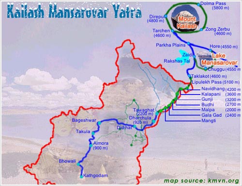
Landslides and the Kailash Mansarovar yatra
One of the great pilgrimages of the Hindu faith is the Kailash Mansarovar Yatra, which is a 400 km trek up to Lake Mansarovar in Tibet. This pilgrimage is very demanding - the lake is at 4550 m above sea level. It is undertaken in groups of 60 people over 26 days. Each year the first group sets off on 1st June.
The route is shown below (from here):

This year the pilgrimage is going to have an additional challenge. I posted back in February about the Chautuldhar landslide in northern India, which was causing major problems in the close area of Tawaghat in Dharchula. The landslide is not quite where I thought it was back then - it now looks as if it is on the section of slope shown on the Google Earth perspective view below:

A close look at the map above will show that Tawaghat is right on the route of the pilgrimage. Unfortunately, the landslide remains active - indeed David Hopkins has been kind enough to send a translation of an article in a local paper for this area, dated 27th May:
To deal with this problem a diversion has been created, but this is reported to be "treacherous" and likely to add two days to the length of the trek.
The route is shown below (from here):
This year the pilgrimage is going to have an additional challenge. I posted back in February about the Chautuldhar landslide in northern India, which was causing major problems in the close area of Tawaghat in Dharchula. The landslide is not quite where I thought it was back then - it now looks as if it is on the section of slope shown on the Google Earth perspective view below:

A close look at the map above will show that Tawaghat is right on the route of the pilgrimage. Unfortunately, the landslide remains active - indeed David Hopkins has been kind enough to send a translation of an article in a local paper for this area, dated 27th May:
"During the past sixty hours rocks and stones have been showering down from the mountain in Chautuldhar. Following the recent rains the mountain in Chautuldhar is on the move again. The temporary road made across the slide has been swallowed up by the river below. People are taking their lives into their hands to cross the slide. With two bulldozers of the BRO (Border Roads Organisation) stuck on the Tawaghat side problems have only increased. From Friday to Sunday following very heavy rains, rocks and boulders are continually raining down from the mountain."
To deal with this problem a diversion has been created, but this is reported to be "treacherous" and likely to add two days to the length of the trek.
Wednesday, January 7, 2009
Another video of the Guatemala landslide
It now appears that there are two videos of the Guatemala landslide. The second one, which is not as clear as the original, has appeared on the Telediaro 3 web site. It can be viewed here:
http://www.telediario.com.gt/index.php?id=15366&tim=#
Meanwhile, there remains considerable uncertainty as to the number of victims (we may never know for certain I suspect), whilst speculation is intensifying regarding the cause. Given the clear size of the landslide (see the video plus the image below from Prensa Libre), comments elsewhere that road widening was the primary trigger look to be wide of the improbable. Clearly there is no record of seismicity or of intense rainfall (everything looks dry in the video). The most likely trigger is therefore progressive failure, which is consistent with reports of increased activity in the fortnight before the failure, reports of the slope emitting noises and the fact that the road had been closed prior to collapse.

Finally, there is continued concerns that a second major failure might occur given the oversteepened nature of the upper part of the slope.
Tuesday, January 6, 2009
The Guatemala landslide was caught on video!
Unbelievably, it turns out that the Guatemalan landslide, which it appears killed at least 42 people, was caught on video. Geologist Marlon Contreras was recording at the edge of the site when the failure occurred. The video captures the movement, although mercifully little of the detail. The video can be viewed at this web page:
http://www.prensalibre.com/pl/2009/enero/06/multimedia.html
The failure that happens 1 minute and 50 seconds into the video defies belief! I urge you to take a look at the video.

Meanwhile, and quite rightly, rescue operations have been halted due to the dangers of continued falling rocks to the rescuers. Given that there is no possibility of any survivors this has to be the right decision, harsh though it undoubtedly is.
Finally, there is still a huge variation in the reported number of victims. Prensa Libre is reporting that 42 people were affected, but other news agencies suggest that it might be double this total, or even more.
Monday, January 5, 2009
Guatemala landslide update: 33 killed and up to 70 people reported missing
A short update on the Guatemala landslide, which is looking like a dreadful tragedy.
Diaro de Centro America has published this dramatic image of the site:

Meanwhile Prensa Libre is reporting that the number of people killed is now known to be 33, with more people still missing. Telediaro suggests that the number missing may be as high as 70 people! Landslides are continuing to hamper the rescue operations.

Guatemala landslide
The first major landslide event of 2008 occurred on Sunday in Alta Verapaz in northern Guatemala. At the moment reports are somewhat fragmented, but the Guatemalan newspaper Prensa Libre has published the following (not great quality) image. I have tried to enhance it as much as I can:
 Clearly this is a major failure - the news report suggests a mass of10,000 tonnes. To date that there are 29 known fatalities plus 15 people reported injured. It appears that there are concerns that the death toll may be much higher as there were 140 people on the road at the time of the failure.
In fact the Prensa Libre report is impressive in terms of the level of geological detail that they provide - far better than is usually the case. A number of key issues emerge:

I will post more as details become available.
 Clearly this is a major failure - the news report suggests a mass of10,000 tonnes. To date that there are 29 known fatalities plus 15 people reported injured. It appears that there are concerns that the death toll may be much higher as there were 140 people on the road at the time of the failure.
In fact the Prensa Libre report is impressive in terms of the level of geological detail that they provide - far better than is usually the case. A number of key issues emerge:
- This same stretch of road suffered a landslide on 14th December that killed two people;
- It was known that another failure was likely, such that the road had been closed. The 140 potential victims appear to have disobeyed instructions when they walked across the affected section;
- The landslide has occurred in an area that is traversed by a known fault, which has weakened the ground and caused water seepage;
- Further failures are feared.

I will post more as details become available.
Tuesday, October 28, 2008
Highway 97 update
Arthon have posted an update on their website of the situation at Highway 97 in Canada:
"Slight movement in Rock Mass overnight. Road likely closed until Thursday at a minimum. Options being considered for removal of rock"
There is also quite a nice news report with footage here. In the report there is a good description of the use of precursor indicators that can be used to warn of a large-scale failure. They are quite right that movement data, sounds, the opening of cracks and the occurrence of small falls can be used to indicate that a large slip might occur. However, they will need to understand the slope quite well before this option is adopted, and they will need to be particularly cautious when it rains or there is snow melt.
Arthon have published some excellent pictures, including a couple of aerial shots, here. The picture below is the best of them to give an oversight of the problem:
 Click on the image for a link to the full size version. Note that a few metres below the main crack there appears to be a smaller tension crack running across the slide, perhaps suggesting that it is starting to break up a little.
Subscribe to:
Posts (Atom)