Showing posts with label california. Show all posts

Friday, March 5, 2010

New rockslide video: Highway 96 at Klamath River near the Siskiyou-Humboldt county line

Thanks to Kyle House of the Nevada Bureau of Mines and Geology for bringing this one to my attention.

A great new video was posted yesterday showing a rockslide onto Highway 96 at Klamath River near the Siskiyou-Humboldt county line in California. The video should be embedded below:

Rock slide on Hwy 96 in Northern California near the Humboldt/Siskiyou County line. from Paul Hailey on Vimeo.


Well worth a look! More details of the slide here:

http://www.redding.com/news/2010/mar/03/staggering-rock-slide-closes-highway-96-near-humbo/

Thursday, February 18, 2010

Impressive roadside landslide in Pomona, California

Thanks to reader CConkle for the heads-up on this one. An impressive slide happened this morning by the side of Freeway 10 near to Pamona in California. The slide has completely blocked the road (pictures from the LA Times):


It is uite interesting that the weather does not indicate an obvious trigger for what appears to be a failure on a reprofiled slope. However, California has suffered recent exceptional rainfall in the last few weeks, so it may be progressive failure is the key factor here.

Most recent reports suggest that the slope is still moving and the road is likely to be closed for a week.

Sunday, February 7, 2010

Mudslides occur in the areas affected by the 2009 Station Fire in Los Angeles

The Station Fire was a huge forest fire that occurred on the northern edge of Los Angeles in late 2009:It was finally brought under control on 16th October 2009, by which time it had burnt a huge area, thought to be over 160,000 acres (image from NASA):


In the aftermath of the fire considerable concern has been expressed about the potential for damaging mudflows in the burnt area, magnified by the current El Nino conditions, which typically bring very heavy rainfall to California at this time of the year.

Early on Saturday, unexpected heavy rainfall triggered a series of mudflows from the burnt area that affected the northern part of Oceanview Boulevard in La Canada Flintridge, causing extensive damage to properties but fortunately no fatalities. The most seriously affected area appears to be Manistree Drive, which is shown on this Google Earth image:

This is apparently the location of this image, from the LA Times:

At least 43 houses were damaged, together with 25 cars (see image below from AP). A dozen houses have reportedly suffered major structural damage.

Sunday, January 17, 2010

Potential landslides in California and the ongoing crisis in Hunza, Pakistan

Amongst the (appropriate) focus upon Haiti at the moment, we must of course remember that landslides do not stop elsewhere. So, here are two important ongoing stories:

1. Potential landslides in California this week:
The US National Weather Service has issued a series of warnings for very heavy rainfall in California this week, with the pontential for landslides, flash flood and debris flows. For example: ...Flash flooding and debris flows possible for recent burn areas In southwestern california late monday morning through monday night... .the first in a series of powerful pacific storms is expected to Move into southern california tonight into monday. Initially...rainfall Is expected to be fairly light...with rainfall coverage and intensities Expected to increase significantly by late monday morning through Monday evening. Rainfall rates between one half inch and three Quarters of an inch per hour will be possible monday afternoon Into monday evening. Local rates over one inch per hour will be possible Near thunderstorms and across favored south facing slopes...including The station and morris burn areas. Rainfall totals with this first Storm system through monday night are generally expected to range Between one and three inches across coastal and valley Areas...with three to five inches in the foothills and Mountains...except local amounts up to 6 inches possible across Favored south facing slopes. For the station burn area...rainfall Totals of 3 to 6 inches can be expected through monday night. Additional periods of heavy rain will be possible later in the Week as future storm systems move into the area...which may Require additional flash flood watches to be issued.

And:
...Wet weather to continue through much of the week... A series of storms...no fewer than six...are lined up across the Pacific all the way to asia. The first of these systems was moving Through the central california interior this afternoon...and will Spread light to moderate rain to the central and southern san Joaquin valley and the adjacent sierra foothills through tonight. Rain also will spread into the high deserts of kern county by late Afternoon and tonight. A second system is developing west of the California coast...and will move into california monday. It is This system that will spread occasional rain...heavy at Times...into the region. For the rest of the week...it is still too early to say when and How much each individual system will impact central california. But there will be periods of rain...heavy at times. Preliminary Indications are for another strong surge of moisture during the Day tuesday...again wednesday...and yet another thursday. Some Decrease in activity is now seen by the weekend...or at least Becoming more showery at times.

There is particular concern about the potential for debris flows in the Station Fire burn zone in the San Gabriel Mountains, as shown in this NASA satellite image:


However, as the La Conchita landslide showed five years ago, many areas in California have the potential for a landslides during very heavy periods of rainfall. It will be an interesting week.


2. The Attabad landslide in Hunza
The blockage of the Karakoram Highway by the Attabad landslide in northern Pakistan continues to cause major problems to that area. Meanwhile, the lake is continuing to fill. The Pamir Times continues to provide excellent coverage of this serious event. Over the weekend they posted a series of images of the slide. First, the lake:


Second the contact between the water and the dam sediment:


And finally the flow path once over-topping is achieved:

In some places the materials look worryingly fine grained and even muddy, but it is impossible to get a proper idea from these images. The report says that the water level is currently 10-15 m from the dam crest, which is of increasing concern. Various reports suggest that there is little government action to date in terms of creating a channel, although clearly this is unverified. It would be unwise to allow the water to flow over the top of the dam without being controlled. However, a report from the ICRC in Pakistan, dated 14th Jan, states that "According to the local government, a dam burst is very highly unlikely to occur."

Monday, September 14, 2009

Interesting landslide footage from La Jolla, California

Image from here

The La Jolla landslide in San Diego California occurred in October 2007, destroying three houses and a road, and leaving many more damaged. The landslide is currently the subject of a lawsuit that was filed by the householders. I am not going to comment further on the slide whilst this is going on, but as part of the evidence in the case some mobile phone footage has emerged of the slide as it occurred. This footage is unusual in that it covers a progressive, non-catastrophic slide, essentially showing the tension cracks opening as the slide occurred. The footage can be viewed here. The complete (8 minute) footage, available on that page, is worth viewing.

Tuesday, May 5, 2009

Nailing Jell-o to a wall...

This is a guest post from Bill Rabenaldt from California about a novel soil nail mitifation technique.

Can you nail jell-o to a wall? Not easily. Can you nail a landslide area, levee or bluff before it fails? You bet!


The valley floors around Aspen, Telluride and other resort areas in the Rockies are all but built out. Where do business and families go? The surrounding hills and mountain sides are all that is available. I’ve seen pictures of several of these homes and they are spectacular. Generally, the home theaters and pools are built into the mountain side due to local height restrictions.

How are they doing it?

For the past 10 years, I have been a member of the Pismo Beach City Council. Our community is on the Central Coast of California half way between San Francisco and Los Angeles, just north of Santa Barbara. During that time, I’ve learned a lot. As an example, our bluff has eroded faster than expected in some areas and we are in immediate danger of losing our highway, force mains and our underground utilities. Pebble Beach was another coastal community that was in danger of having their main arterial fall into the ocean. Trying to figure out how we can overcome these natural and man-made disasters has been my personal and political motivation for many years.

There are also the devastating fires we’ve had around the world. Rains are causing landslides of varying proportion. Our once stable private and public property is now vulnerable to the forces of nature. Our levee system is old and decaying.

There is a company I’ve been following for about 7 years. I first met them at the League of California Cities meeting in Sacramento. Soil Nail Launcher had a booth at the event and I was interested in how an 8 foot nail could be driven into an embankment. Over the years, I understand they have driven many nails and have protected a whole lot of property. Not only that, they have done it for less than half the cost of traditional methods.

Here is a short story you will enjoy:

In WW2, Great Britain developed a gas canister launcher to stop the enemy’s progress. A canister could be launched as far as 3 miles away. Several years ago, a company bought this equipment and all the patents and converted it to a “soil nail launcher”. 2,500 psi is built up in a chamber and launches a nail at 220 mph into the unstable soil. These nails are typically between 12 and 20 feet long with a Super Launcher that penetrates up to 80 feet. The area is then left to nature or a shotcrete surface can be applied.

If you would like to see what intrigued me the most, go to their website: www.landslidesolutions.com to see what they have accomplished. Their services are averaging half of the cost of traditional “fixes”, they were approved by the California Coastal Commission, they have recently received a GSA (General Services Administration) contract number from the Federal Government for emergency services. They can solve geotechnical, construction and public safety problems.


A recent report by the geological society on the new faults found along the infamous San Andreas Fault causes serious doubt as to the earlier government findings of “acceptable standards” for construction, land use issues, and a host of other many other conclusions that must be reviewed. Many may need to be reconsidered and/or revised with this new information. Reinforcement may be the only logical solution.

Tuesday, March 10, 2009

USGS educational video on landslides in the San Francisco Bay Area

Thanks to the Geology blog In Terra Veritas for highlighting a USGS video on landslides in the San Francisco Bay area. The video is a useful teaching / background resource, especially in terms of the way that it highlights the impacts of landslides on home owners, which is easily forgotten by both students and their teachers. The video compares two different slides; first, the Love Creek Heights landslide in the Santa Cruz Mountains, which was a large (600 m long x 250 m wide; 500,000 cubic metres) slide triggered by a heavy rainstorm on 5th January 1982. It killed 10 people.

The second is the La Honda landslide, which is a slow moving failure, also in the Santa Cruz mountains. This slide was the subject of one of my very first posts in December 2007.

Overall, this video is a useful resource that helps to understand landslides themselves and also their impact.

Tuesday, December 2, 2008

Burning landslides revisited...

Back in August I posted on the strange phenomenon of burning landslides. This is an interesting and surprisingly common phenomenon in which a slope failure exposes materials in the soil or rock that oxidises to generate large amounts of heat. At times this effect can be strong enough to actually ignite - in Dorset in England for example organic matter in the Kimmeridge Clay (which is the main source rock for North Sea Oil) has often ignited after landslides.

In the latest edition of the journal Geology, a paper by Robert Mariner and his colleagues at the USGS at 
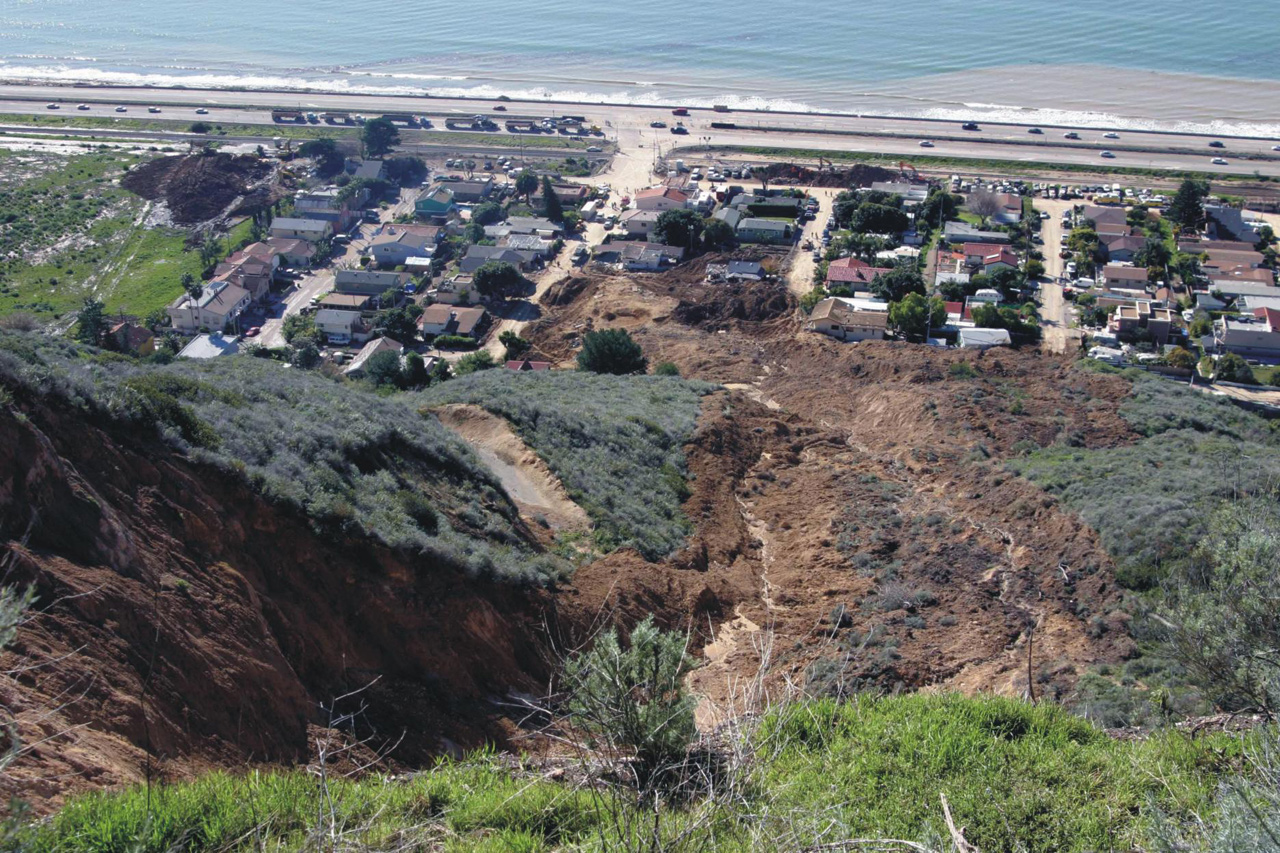
Menlo Park in California report upon a forest fire that occurred about 40 km northeast of Santa Barbara. The fire was quickly extinguished, but subsequent investigations showed the seat of the blaze was a 7 hectare landslide, from which hot gas was being emitted via a series of fumaroles. The team measured the temperatures in some of the fumaroles and also in a borehole drilled near to one of them. The measured temperatures were as high as 262 C in a fumarole and 307 C in the borehole. The ignition temperature for dry grass is 150-200 C, so it is not hard to work out where the fire started!

The team report suggest that pyrite in the shale bedrock was exposed by the slide and oxidised rapidly, generating heat. The temperatures were high enough to ignite carbonaceous matter in the shale, which then burnt to create the fumaroles, which in turn started the forest fire. This view is supported by the isotopic composition of the gases emitted by the fumaroles.

Interestingly, the paper notes that the team are "surprised that the phenomenon is rare because siltstone-shale sequences commonly have pyrite and organic matter and are involved in landslides", suggesting that maybe this happens more often than we realise.

Overall this is an excellent paper on a slightly esoteric but very interesting topic.

Reference
Robert H. Mariner, Scott A. Minor, Allen P. King, James R. Boles, Karl S. Kellogg, William C. Evans, Gary A. Landis, Andrew G. Hunt, and Christy B. Till, 2008. A landslide in Tertiary marine shale with superheated fumaroles, Coast Ranges, California. Geology, 36 (12) 959-62.

Wednesday, August 20, 2008

La Conchita landslide verdict

Many readers will be familiar with the La Conchita landslide in California. For those who aren't, La Conchita a small (population about 340 people), unincorporated seaside village located on the Pacific coast north of Los Angeles (Fig. 1) (34.4 degrees north, 119.5 degrees west). The town is located on a narrow coastal plain, with a steep slope behind. The houses are very close to the foot of the slope (Fig 2).

Fig 1: Google Earth image showing the location of La Conchita

Fig 2: Oblique Google Earth image showing the town of La Conchita with the steep slope behind. Note the very clear landslide scars

The town shot into the limelight on 4th March 1995 when a landslide slipped off the slope and buried or damaged seven houses. Fortunately no-one was killed, but it clearly caused considerable concern. The landslide is the subject of perhaps one of the most famous of all landslide pictures, taken by the USGS (Fig. 3). The landslide was large (120 m wide, 330 m long, and >30 m deep, with an estimated volume of 1.3 million cubic metres. However, the slide occurred as a coherent earthflow and was comparatively slow.

Fig 3: USGS image of the 1995 La Conchita landslide

Unsurprisingly, in the aftermath of the landslide concerns were raised about the safety of the town. In particular, it is clear from Figure 2 that the slope is mantled with old landslide scars and deposits. There was consistency in the views of the experts that further landslides on the slope were likely. Sadly, this proved to be correct because on 10th January 2005, during a period of very heavy rainfall, a further landslide occurred. On this occasion a portion of the failed mass from 1995 remobilised and hit the upper part of the town.

Fig 4: USGS image of the 2005 La Conchita landslide

Amazingly, the failure of the upper part of the landslide was caught by a TV crew (see here or below).


The video makes it clear that this time the failure was a comparatively rapid flow slide, probably in a dry state (see the dust in the video) but moving on a saturated layer. The landslide was much smaller than the 1995 one (about 200,000 cubic metres), but as it was so much more mobile it hit and buried or damaged 31 houses. Sadly ten people were killed, including a mother and her three daughters.

Inevitably the landslide led to a court case. This has been protracted, with various permutations that are beyond the scope of this post, but in the end it came down to the people of the town suing the owners of the ranch at the top of the slope, claiming that they were negligent, primarily because it was alleged that their irrigation of the land contributed to the high ground water levels that induced failure of the slope. Many of us in the landslide community were intrigued to see how this would play out because of the known level of landslide risk at this site. In particular, examination of an oblique image of the site leaves one in no doubt that the 1995 and 2005 slides were part of a much larger, ancient landslide complex affecting the whole of the slope (Fig. 5). Considering that this is an area of high seismic activity, and the slope has a known history of active movements, the management of risk here was extremely interesting.

Fig. 5: USGS false colour image of the La Conchita landslide complex, annotated to show the key features

Yesterday, the main part of the court case brought by the property owners against the ranch owners came to an end. I have no knowledge of the US legal system, but interestingly the verdict of the jury is that the ranch company was negligent in connection with the 2005 landslide. The land owners had claimed that the ranch company did not build an adequate drainage system. This was felt to have contributed to the event. As I understand it the drainage system was not found to be the sole cause, meaning that the negligence is shared. The court case has now moved into a second phase in which the jury will decide upon damages. Because of this it would be wrong to comment on the rights and wrongs of this case at this stage (I will do so later), but it will certainly be interesting to see what the jurors award, and to whom.