Please do register to come along!
Showing posts with label coastal erosion. Show all posts
Tuesday, March 9, 2010
Free workshop on coastal erosion, 19th March 2010
We are running a free workshop on erosion on 19th March 2010 in North Yorkshire, UK. Details in the flyer below, together with contact details (click on the image for a better view in a new window).
Please do register to come along!
Thursday, February 25, 2010
Coastal erosion as art
The Guardian has a slightly bizarre article today. It is entitled "The art of watching your house fall into the sea". It tells the story of artist Kane Cunningham, who has bought a bungalow on the cliff edge at Knipe Point near to Scarborough. This site has been featured here before as recent landsliding has threatened to destroy a number of houses. He says in the article:
"I'm going to turn the moment my studio collapses into an art work: I've set up cameras to film it, and I've commissioned music and poetry to celebrate it. Both our houses punch a hole in what we think of as the value of property, and remind us of our moral and ethical responsibility to nature... When my studio disappears, I'll have no sense of loss – that will be its beautiful final act. The sooner it goes, for me, the better."
He has a website about this here. Quite bizarre, but it could be very interesting to watch.
Thursday, January 28, 2010
Earthquake-driven coastal erosion (or a coastal lateral spread) in Haiti
The Discovery Channel has news of a very interesting example of rapid coastal erosion driven by the earthquake in Haiti. The site is at Petit Paradis to the west of Port-au-Prince. Eye-witness reports suggest that the town was struck by a highly localised tsunami in the earthquake, apparently killing 20. This is interesting in part because it is quite likely such a localised event would have been caused by a (submarine?) landslide - not at all unusual in earthquakes. However, the before and after satellite images show the magnitude of the changes on the coastline in this area.
Before:

And after:

At first glance the change does not look so dramatic, but take a look at the location of the coastline in the before image in relation to the white building that I have highlighted below:

Actually, it is a little more interesting than you might initial suppose. First, note that the section of coast that has "disappeared" lies only between the two yellow dots that I have marked on the image above. To the east and the west the beach is intact. Second, take a look at this CNN video:
The key aspect is the picture of that lone tree standing upright in the ocean. A USGS report has suggested this is the site of a lateral spread (the same type of landslide that is evident in the port area of Port-au-Prince), which has caused the coastline to slip into the sea. As lateral spreads are essentially translational, a tree can remain upright. Unfortunately, as the coastline is now no longer protected by a beach, further erosion is likely. An interesting hypothesis is of course that this not-insubstantial slip caused the localised tsunami - or could it be that there was no wave at all, just the appearance of one to those people standing on the land as it slipped below the waves?
Before:

And after:

At first glance the change does not look so dramatic, but take a look at the location of the coastline in the before image in relation to the white building that I have highlighted below:

Actually, it is a little more interesting than you might initial suppose. First, note that the section of coast that has "disappeared" lies only between the two yellow dots that I have marked on the image above. To the east and the west the beach is intact. Second, take a look at this CNN video:
The key aspect is the picture of that lone tree standing upright in the ocean. A USGS report has suggested this is the site of a lateral spread (the same type of landslide that is evident in the port area of Port-au-Prince), which has caused the coastline to slip into the sea. As lateral spreads are essentially translational, a tree can remain upright. Unfortunately, as the coastline is now no longer protected by a beach, further erosion is likely. An interesting hypothesis is of course that this not-insubstantial slip caused the localised tsunami - or could it be that there was no wave at all, just the appearance of one to those people standing on the land as it slipped below the waves?
Wednesday, December 16, 2009
AGU Day 3
There were two highlights of day 3 for me, which to be honest did not have much of interest on landslides. The first was the Geobloggers lunch, which was attended by about 30 bloggers. It was interesting to put names to faces and also to learn about some new blogs. I was struck by two things: 1. the range of ages of bloggers - far less oriented towards the young than I had expected; and 2. the diversity of reasons for blogging. All were pretty sure that they got a lot out of it and were enthusiastic about the role that they play. I sense that organisations like AGU have a sense that blogs and bloggers need to be a part of their future, but don't know what that role would be. I am not sure that this session will have helped though!
The second was a session on coastal processes, mostly focused on erosion. In most cases erosion is a mass movement (landslides or rockfalls) process of course, so this was of direct relevance. I presented the work of my PhD student Emma Norman, and a post-doc in my team, Mike Lim, presented his work too. There was one other hard rock talk, a presentation from Limber and colleagues on the development of a model for coastal erosion, with an emphasis on how bays and headlands form. The headline message was interesting - that headlands can only be preserved if erosion is enhanced in bays by small pocket beaches, which provide sediment that increases the rate of abrasion on the cliffs. This is all very well, but the model appeared to over-simplify to the point of irrelevance. I sensed that the audience was pretty frustrated too, with a quite pointed question about the assumption that the geology is homogeneous.
After that attention turned to erosion in the Arctic. This session was started with a quite surreal presentation. Jesse Walker is one of the gods of Arctic geomorphology, so the convenors asked him to attend to give a presentation on this theme as background. Unfortunately he was unwell - I hope he recovers quickly - so one of the session chairs gave it on his behalf. A presentation of over 50 slides in 15 minutes by someone who did not put together the talk was not a great experience, although the presenter did the very best he could in the circumstances.
Afterwards there were four rather mixed presentations on the processes and rate of coastal erosion in Alaska. The underlying message is startling - erosion rates of 10-15 m per year are common at these latitudes. Given that most of the erosion occurs in a very short summer season, this gives retreat rates of 10 to 15 cm per day!!! One of the speakers, Cameron Wobus, presented some fabulous time-lapse photography over a full summer season to show this erosion. Just to give you an idea of how fast this erosion occurs, the image below is from his website, showing just a few years of retreat:
The real concern must be the response of this system to the rapid and massive changes in temperature and summer ice cover at these high latitudes. The eroding bluffs primarily consist of ice (dirty icebergs was one description of them). The warming is causing increases in erosion because:
1. The temperatures are warmer so the bluffs are thawing;
2. Under normal conditions at the start and end of the warm season the shore is protected by ice berms - basically marine ice that has blown onshore. These berms are smaller and are melting faster;
3. The loss of sea ice in the summer means that the waves have a larger fetch, so that they are larger and more powerful;
4. The melting season has become longer;
5. Sea level is rising;
6. The time period of ice free marine conditions each year is longer, so the sea erodes for more time;
7. The sea is warmer so can erode more quickly (much of the erosion is caused by the warm sea melting a notch in the bluff).
Overall the picture painted was alarming. As Tom Ravens said, most coastal erosion in the US is undertaken in the south where rates are generally small. The reality is that the serious problems are in the high latitudes, so there is a desperate need to reorient coastal research.
Tomorrow is the main landslide day. This appears to have a mass of stuff of interest. I can't wait. Tonight I have to work on a research grant proposal - what joy!
The second was a session on coastal processes, mostly focused on erosion. In most cases erosion is a mass movement (landslides or rockfalls) process of course, so this was of direct relevance. I presented the work of my PhD student Emma Norman, and a post-doc in my team, Mike Lim, presented his work too. There was one other hard rock talk, a presentation from Limber and colleagues on the development of a model for coastal erosion, with an emphasis on how bays and headlands form. The headline message was interesting - that headlands can only be preserved if erosion is enhanced in bays by small pocket beaches, which provide sediment that increases the rate of abrasion on the cliffs. This is all very well, but the model appeared to over-simplify to the point of irrelevance. I sensed that the audience was pretty frustrated too, with a quite pointed question about the assumption that the geology is homogeneous.
After that attention turned to erosion in the Arctic. This session was started with a quite surreal presentation. Jesse Walker is one of the gods of Arctic geomorphology, so the convenors asked him to attend to give a presentation on this theme as background. Unfortunately he was unwell - I hope he recovers quickly - so one of the session chairs gave it on his behalf. A presentation of over 50 slides in 15 minutes by someone who did not put together the talk was not a great experience, although the presenter did the very best he could in the circumstances.
Afterwards there were four rather mixed presentations on the processes and rate of coastal erosion in Alaska. The underlying message is startling - erosion rates of 10-15 m per year are common at these latitudes. Given that most of the erosion occurs in a very short summer season, this gives retreat rates of 10 to 15 cm per day!!! One of the speakers, Cameron Wobus, presented some fabulous time-lapse photography over a full summer season to show this erosion. Just to give you an idea of how fast this erosion occurs, the image below is from his website, showing just a few years of retreat:
The real concern must be the response of this system to the rapid and massive changes in temperature and summer ice cover at these high latitudes. The eroding bluffs primarily consist of ice (dirty icebergs was one description of them). The warming is causing increases in erosion because:1. The temperatures are warmer so the bluffs are thawing;
2. Under normal conditions at the start and end of the warm season the shore is protected by ice berms - basically marine ice that has blown onshore. These berms are smaller and are melting faster;
3. The loss of sea ice in the summer means that the waves have a larger fetch, so that they are larger and more powerful;
4. The melting season has become longer;
5. Sea level is rising;
6. The time period of ice free marine conditions each year is longer, so the sea erodes for more time;
7. The sea is warmer so can erode more quickly (much of the erosion is caused by the warm sea melting a notch in the bluff).
Overall the picture painted was alarming. As Tom Ravens said, most coastal erosion in the US is undertaken in the south where rates are generally small. The reality is that the serious problems are in the high latitudes, so there is a desperate need to reorient coastal research.
Tomorrow is the main landslide day. This appears to have a mass of stuff of interest. I can't wait. Tonight I have to work on a research grant proposal - what joy!
Sunday, November 8, 2009
Coastal erosion and climate change: Implications for the shoreline over the next century
On Friday I gave a public lecture at the Badbury Centre in North Yorkshire (NE England), looking at the potential impacts of climate change on coastal erosion. The presentation was focused on the field site that we maintain at Boulby, close to the lecture venue. In the presentation I start by looking at our landslide database and then go on to talk about climate change. The main part of the presentation is an examination of the likely impact of climate change, looking at the ways in which potential erosion rates have been determined, and then using our own very high resolution work to examine how this can be done properly. I hope that in the presentation I show that in this area at least the impacts of climate change on erosion are not as great as some might fear, and that proper scientific analysis allows one to develop proper models of future impacts.
I must stress here that this does not suggest that climate change is not a real and urgent problem - it is - and in the talk and in the questions afterwards I stressed the vital importance of a successful outcome to the Copenhagen talks.
The presentation is available via Authorstream below:
My personal Authorstream page, which contains a selection of my recent presentations, is available here:
www.authorstream.com/user-presentations/Dr_Dave/
I must stress here that this does not suggest that climate change is not a real and urgent problem - it is - and in the talk and in the questions afterwards I stressed the vital importance of a successful outcome to the Copenhagen talks.
The presentation is available via Authorstream below:
My personal Authorstream page, which contains a selection of my recent presentations, is available here:
www.authorstream.com/user-presentations/Dr_Dave/
Friday, September 11, 2009
Coastal erosion - the last groyne problem
One of the most emotive topics for local authorities in the UK is that of coastal erosion. Over the last few years in Britain we have increasingly taken a view that coasts should only be defended where absolutely necessary - elsewhere erosion should be allowed to occur at a "natural" rate. In most cases the view has been taken that protection of coasts in which erosion will affect domestic properties (i.e. peoples' houses) does not qualify as necessary. This is particularly harsh for those whose properties are affected by erosion - in the UK domestic insurance does not cover erosion and there is currently no compensation scheme for people whose houses are affected by erosion. Even worse, when the house becomes dangerous the local authority will often take possession of the hose and demolish it. Guess who gets the bill for the demolition...
One of the key reasons for choosing not to protect coasts is the so-called "last groyne" problem. This occurs at the point of the last (down drift) part of the coast that is protected. Here, the coastal protection updrift typically starves the coast of sediment that would normally provide some protection against erosion, leading to greatly increased erosion rates at this point. I was playing with the historic imagery feature on Google Earth this week and came across a very clear example of this problem, from the east coast of Britain.
Here is an image collected in 1999 of the site in question. As ever, click on the image for a better view in a new window:

Here, longshore drift is from the northwest to the southeast, such that the groyne (sea defence) in the centre of the image is the last of the chain. Most of these sea defences have been in place for half a century. What should be immediately obvious is the way that the coast steps back at the point of the last groyne, indicating the much higher erosion rate at this point.
Let's now zoom forward just seven years to an image that was taken in 2006:
The change in this period is quite startling when you look closely. First, you will see that the area previously affected by enhanced erosion has retreated further. The sea defence has broken down and three houses have been lost. It appears that some rock armour has been dumped at this point to try to reduce erosion. The sea has also breached and destroyed the coastal defence just to the NW of this point, and as a result the coast has started to erode. In consequence a whole series of properties have been lost along this frontage.
The town in question is called Happisburgh. The residents have a campaign to try to have sea defences constructed, with an excellent website.
Perhaps most startling is this image, from a sequence of aerial photographs, which shows the same location in 1986:
At this point the groynes were intact all the way down the coast, and the current step back is not present. Therefore, the big step back in the coast that is seen in the first image above occurred in just 13 years.
One of the key reasons for choosing not to protect coasts is the so-called "last groyne" problem. This occurs at the point of the last (down drift) part of the coast that is protected. Here, the coastal protection updrift typically starves the coast of sediment that would normally provide some protection against erosion, leading to greatly increased erosion rates at this point. I was playing with the historic imagery feature on Google Earth this week and came across a very clear example of this problem, from the east coast of Britain.
Here is an image collected in 1999 of the site in question. As ever, click on the image for a better view in a new window:

Here, longshore drift is from the northwest to the southeast, such that the groyne (sea defence) in the centre of the image is the last of the chain. Most of these sea defences have been in place for half a century. What should be immediately obvious is the way that the coast steps back at the point of the last groyne, indicating the much higher erosion rate at this point.
Let's now zoom forward just seven years to an image that was taken in 2006:
The change in this period is quite startling when you look closely. First, you will see that the area previously affected by enhanced erosion has retreated further. The sea defence has broken down and three houses have been lost. It appears that some rock armour has been dumped at this point to try to reduce erosion. The sea has also breached and destroyed the coastal defence just to the NW of this point, and as a result the coast has started to erode. In consequence a whole series of properties have been lost along this frontage.The town in question is called Happisburgh. The residents have a campaign to try to have sea defences constructed, with an excellent website.
Perhaps most startling is this image, from a sequence of aerial photographs, which shows the same location in 1986:
At this point the groynes were intact all the way down the coast, and the current step back is not present. Therefore, the big step back in the coast that is seen in the first image above occurred in just 13 years.
Tuesday, May 5, 2009
Nailing Jell-o to a wall...
This is a guest post from Bill Rabenaldt from California about a novel soil nail mitifation technique.
Can you nail jell-o to a wall? Not easily. Can you nail a landslide area, levee or bluff before it fails? You bet!

The valley floors around Aspen, Telluride and other resort areas in the Rockies are all but built out. Where do business and families go? The surrounding hills and mountain sides are all that is available. I’ve seen pictures of several of these homes and they are spectacular. Generally, the home theaters and pools are built into the mountain side due to local height restrictions.
How are they doing it?
For the past 10 years, I have been a member of the Pismo Beach City Council. Our community is on the Central Coast of California half way between San Francisco and Los Angeles, just north of Santa Barbara. During that time, I’ve learned a lot. As an example, our bluff has eroded faster than expected in some areas and we are in immediate danger of losing our highway, force mains and our underground utilities. Pebble Beach was another coastal community that was in danger of having their main arterial fall into the ocean. Trying to figure out how we can overcome these natural and man-made disasters has been my personal and political motivation for many years.
There are also the devastating fires we’ve had around the world. Rains are causing landslides of varying proportion. Our once stable private and public property is now vulnerable to the forces of nature. Our levee system is old and decaying.
There is a company I’ve been following for about 7 years. I first met them at the League of California Cities meeting in Sacramento. Soil Nail Launcher had a booth at the event and I was interested in how an 8 foot nail could be driven into an embankment. Over the years, I understand they have driven many nails and have protected a whole lot of property. Not only that, they have done it for less than half the cost of traditional methods.
Here is a short story you will enjoy:
In WW2, Great Britain developed a gas canister launcher to stop the enemy’s progress. A canister could be launched as far as 3 miles away. Several years ago, a company bought this equipment and all the patents and converted it to a “soil nail launcher”. 2,500 psi is built up in a chamber and launches a nail at 220 mph into the unstable soil. These nails are typically between 12 and 20 feet long with a Super Launcher that penetrates up to 80 feet. The area is then left to nature or a shotcrete surface can be applied.
If you would like to see what intrigued me the most, go to their website: www.landslidesolutions.com to see what they have accomplished. Their services are averaging half of the cost of traditional “fixes”, they were approved by the California Coastal Commission, they have recently received a GSA (General Services Administration) contract number from the Federal Government for emergency services. They can solve geotechnical, construction and public safety problems.

A recent report by the geological society on the new faults found along the infamous San Andreas Fault causes serious doubt as to the earlier government findings of “acceptable standards” for construction, land use issues, and a host of other many other conclusions that must be reviewed. Many may need to be reconsidered and/or revised with this new information. Reinforcement may be the only logical solution.
Can you nail jell-o to a wall? Not easily. Can you nail a landslide area, levee or bluff before it fails? You bet!

The valley floors around Aspen, Telluride and other resort areas in the Rockies are all but built out. Where do business and families go? The surrounding hills and mountain sides are all that is available. I’ve seen pictures of several of these homes and they are spectacular. Generally, the home theaters and pools are built into the mountain side due to local height restrictions.
How are they doing it?
For the past 10 years, I have been a member of the Pismo Beach City Council. Our community is on the Central Coast of California half way between San Francisco and Los Angeles, just north of Santa Barbara. During that time, I’ve learned a lot. As an example, our bluff has eroded faster than expected in some areas and we are in immediate danger of losing our highway, force mains and our underground utilities. Pebble Beach was another coastal community that was in danger of having their main arterial fall into the ocean. Trying to figure out how we can overcome these natural and man-made disasters has been my personal and political motivation for many years.
There are also the devastating fires we’ve had around the world. Rains are causing landslides of varying proportion. Our once stable private and public property is now vulnerable to the forces of nature. Our levee system is old and decaying.
There is a company I’ve been following for about 7 years. I first met them at the League of California Cities meeting in Sacramento. Soil Nail Launcher had a booth at the event and I was interested in how an 8 foot nail could be driven into an embankment. Over the years, I understand they have driven many nails and have protected a whole lot of property. Not only that, they have done it for less than half the cost of traditional methods.
Here is a short story you will enjoy:
In WW2, Great Britain developed a gas canister launcher to stop the enemy’s progress. A canister could be launched as far as 3 miles away. Several years ago, a company bought this equipment and all the patents and converted it to a “soil nail launcher”. 2,500 psi is built up in a chamber and launches a nail at 220 mph into the unstable soil. These nails are typically between 12 and 20 feet long with a Super Launcher that penetrates up to 80 feet. The area is then left to nature or a shotcrete surface can be applied.
If you would like to see what intrigued me the most, go to their website: www.landslidesolutions.com to see what they have accomplished. Their services are averaging half of the cost of traditional “fixes”, they were approved by the California Coastal Commission, they have recently received a GSA (General Services Administration) contract number from the Federal Government for emergency services. They can solve geotechnical, construction and public safety problems.

A recent report by the geological society on the new faults found along the infamous San Andreas Fault causes serious doubt as to the earlier government findings of “acceptable standards” for construction, land use issues, and a host of other many other conclusions that must be reviewed. Many may need to be reconsidered and/or revised with this new information. Reinforcement may be the only logical solution.
Thursday, January 22, 2009
Whitby - the old and the new
As someone interested in earth processes, one of the great powers of the internet is the ability to access quickly images of places in which I am interested. Over the last few years my colleagues and I have been studying rockfall processes at the town of Whitby in N. Yorkshire, which is in NE. England. I thought as a bit of fun I would compare two images of the cliffs in the town. The first, assessed from here, was taken in the 1900's - i.e. a century ago:

The second, accessed from here, was taken in the last few years:

There are several things of interest here. It is important to note that the two images were not taken from quite the same angle -the 2000's image was taken further from the sea than was the 1900's one, though there is not much difference. However, there is quite a lot of interest here. First, note the very different beaches between the two images - in the 1900's image there is very little beach visible, and indeed boats are moored by the small pier. Now the beach has encroached into this area, presumably through natural accretion though I guess it could have been artificially stocked.
More interesting, the profile of the cliff has changed dramatically. The cliff a century ago was far less steep, with a large, protruding toe. In the recent image most of this toe has been eroded away, leaving a far steeper profile. Interestingly though the profile of the top of the slope is little changed, except being a little steeper. Presumably as the toe continues to erode, and thus the slope to steepen, the rate of erosion at the top will increase, or a large failure will occur that will cause the cliff top to erode back a few metres. Fortunately, it is a long way to the abbey and church, and there is little else at the cliff top to worry about unduly.

The second, accessed from here, was taken in the last few years:

There are several things of interest here. It is important to note that the two images were not taken from quite the same angle -the 2000's image was taken further from the sea than was the 1900's one, though there is not much difference. However, there is quite a lot of interest here. First, note the very different beaches between the two images - in the 1900's image there is very little beach visible, and indeed boats are moored by the small pier. Now the beach has encroached into this area, presumably through natural accretion though I guess it could have been artificially stocked.
More interesting, the profile of the cliff has changed dramatically. The cliff a century ago was far less steep, with a large, protruding toe. In the recent image most of this toe has been eroded away, leaving a far steeper profile. Interestingly though the profile of the top of the slope is little changed, except being a little steeper. Presumably as the toe continues to erode, and thus the slope to steepen, the rate of erosion at the top will increase, or a large failure will occur that will cause the cliff top to erode back a few metres. Fortunately, it is a long way to the abbey and church, and there is little else at the cliff top to worry about unduly.
Friday, January 2, 2009
Evaluating coastal erosion using art
The BBC is carrying a quite interesting story at the moment about the use of artwork from the nineteenth century to evaluate rates of coastal erosion. The story originates from Robin McInnes, who is an established figure in coastal management. Robin was the Coastal Manager for the Isle of Wight, in southern England for many years, during which he led the way in terms of developing an understanding and management of coastal erosion. This ended somewhat abruptly a couple of years ago. Fortunately, Robin is clearly still active in an independent capacity.
The work has been written up in a short but useful report that is available here. There was also a New Scientist article that featured this approach in the middle of last year.
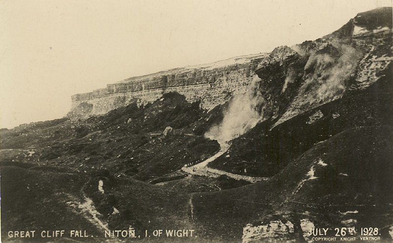
The Isle of Wight is well known as a zone of active coastal erosion, most notably as a result of a series of large landslides along the southern coast, including probably one of the earliest events captured on camera:
Fortunately, the south coast of the Isle of Wight is also both beautiful and accessible. It was a particularly fashionable tourist destination of the rich and famous in Victorian (mid to late 19th century) times, which meant that it was also frequently captured in artwork. Robin McInnes has amassed over 400 pieces of artwork from the period 1770 onwards. He has graded the quality of depiction of each artist in order to determine which provides a representation that is sufficiently reliable to be usable today. McInnes suggests that good quality depictions can be used to:

The image below is a photograph from the 1890's of Steephill Cove in Ventnor (from here):

Here is a photograph of Steephill Cove from 1906 (from here):

And finally, here is a modern day image (from here):
The work has been written up in a short but useful report that is available here. There was also a New Scientist article that featured this approach in the middle of last year.
The Isle of Wight is well known as a zone of active coastal erosion, most notably as a result of a series of large landslides along the southern coast, including probably one of the earliest events captured on camera:
- Understand geological structure and form (especially where the artists depicted a landscape that has now been built over or forested);
- Examine changes in geomorphological structures or processes;
- Determine changes in beach geometries;
- Compare changes in coastal morphology due to erosion;
- Provide a chronology of coastal defences;
- Establish the evolution of estuaries and harbours;
- Provide an insight into habitat change.

The image below is a photograph from the 1890's of Steephill Cove in Ventnor (from here):

Here is a photograph of Steephill Cove from 1906 (from here):

And finally, here is a modern day image (from here):
Subscribe to:
Posts (Atom)