Tomorrow (Friday) I am giving a talk at Hazards Day in Manchester for AS/A2 students (year 12 and Year 13 in the UK system). The topic is the hazards associated with the Wenchuan (Sichuan) Earthquake in China. I have uploaded the file below:
Uploaded on authorSTREAM by Dr_Dave
This talk will be repeated at an event in London on Thursday 4th December.
Thursday, November 27, 2008
Wednesday, November 26, 2008
Extraordinary landslide video
In addition to the two landslide videos from Brazil, I have now come across an even more extraordinary video. This is apparently of a landslide that occurred in Mesitas in Colombia. Whilst the footage of the landslide itself is not as good as some others, the power of the slide as it hits a house is starkly illustrated. Unfortunately I cannot embed this one, so you will need to click the link below:
National Geographic Landslide Video
Absolutely incredible!
National Geographic Landslide Video
Absolutely incredible!
Brazil landslide disaster videos
Unfortunately Santa Catarina Province in Brazil is currently being affected by dreadful landslides and floods associated with a period of exceptionally heavy rainfall. The death toll is rising rapidly.
Incredibly, Brazilian news agencies appear to have caught at least two landslides in action. They can both be seen in the following Youtube video:
The first occurs right at the start of the clip. Unfortunately the film does not cover all of the slide, just the first few seconds. This is better caught on a video that I cannot embed, but which is at the start of the clip that can be found here. The second occurs at about the 16th second of the embedded video. I hope that better resolution film will appear in due course - please let me know if you come across it.
Meanwhile, a few images are appearing of the landslide damage, such as this:

UPDATE: I have now found a Youtube version of the first of the landslides above. Hopefully it will play below:
Tuesday, November 25, 2008
World Landslide Forum Report
Readers will probably be aware that last week the First World Landslide Forum was held at the United Nations University in Tokyo. This was apparently "a global cooperation platform for all types of organizations from academia, United Nations, governments, private sectors, and individuals which are willing to contribute for landslide and other related earth system risk reduction."
Unfortunately I wasn't able to attend, but two of my colleagues (Nick Rosser and Mike Lim) were there and have kindly written the following conference report. Thanks very much to them for doing this.

Unfortunately I wasn't able to attend, but two of my colleagues (Nick Rosser and Mike Lim) were there and have kindly written the following conference report. Thanks very much to them for doing this.

The First World Landslide Forum was held last week at the United Nations University, Tokyo, Japan. The initiative for this meeting has been driven by the International Programme on Landslides (IPL) under the remit of strengthening research and learning on Earth system risk analysis and sustainable disaster management. The meeting was attended by 450 delegates from 49 countries. Although attracting participants from beyond the normal geo-science conference circuit, there were also notable absences.
Continuing the focus on management issues raised in the preceding Sendai satellite conference, the need to marry scientific knowledge with practical site-specific implementation was stressed in opening addresses by representatives of the many organisations officiating. Konrad Osterwalder gave an eloquent address on behalf of the host United Nations University. He suggested that the crippling costs of landslides, driven by a lack of preparedness, can only be mitigated through a concerted effort towards resilience where the connectivity between the human and natural environments is fully appreciated; a theme which the following sessions attempted to follow. The welcome was concluded with a short play recounting the experiences a group of children who survived the 2006 Leyte landslide disaster. The play was a poignant reminder of the human cost of landslide disasters. Although not as punctual as the Shinkansen, the five parallel sessions of papers covered a range of topics from landslide mapping and early warning to social impacts and interesting country case studies, most with time for discussion.
Amongst the highlights were some interesting contributions from Jon Godt (USGS), Ken Hewitt (Canada), Janus Wasowski (Italy), Masahiro Chigira (Japan), and Sandre Catane (Phillipines). Jon Godt presented recent developments of the USGS near-real-time earthquake induced landslide prediction models, developed upon the PAGER platform. Based on the 1994 Mw=6.7 Northridge earthquake in California, the model uses a combination of modelled peak ground acceleration from tele-seismic monitoring combined with SRTM derived topography, coarse resolution geological mapping and material properties to predict the potential locations of failures. Jon presented an application of the technique to the 2008 Wenchuan earthquake, showing that the results demonstrated a basic similarity with the initial post-earthquake mapping, which was later presented in several papers in this session. Of these the presentation by Masahiro Chigira gave a comprehensive overview with landslide locations mapped primarily from ALOS PRISM data. Professor Chigira demonstrated the concentration of the failures along the fault rupture, with a tendency of failures to follow both topographic ridges, in addition to appearing to follow the main river valleys. A tendency for landslides to be oriented NW – SW was highlighted, most probably reflecting the fault controlled topographic alignment, in addition to some interesting observations of ruptures on calcium carbonate surfaces.
The all encompassing ‘catastrophic slides and avalanches’ session began with an engaging presentation from Professor Ken Hewitt, on his work identifying massive rock avalanches in the Nanga Parbat-Haramosh massif in Northern Pakistan. Ken gave a compelling overview of the changing interpretation of Himalaya landforms, suggesting that the frequency of large rockslides may actually be significantly greater than we believe. Without adequate dating of these now numerous identified failures, their temporal spacing and frequency remains a mystery, but they may hold significant information on mountain chain evolution given their impact and persistence. This is clearly an important subject for further research.
The ‘view from space’ session saw a range of papers, many applying the PSInSAR technique for landslide monitoring. Of note was a critical overview by Janus Wasowski of some of the challenges that remain when applying this technique. Janus demonstrated the apparent mismatch of displacement measurement identified by ascending and descending orbit imagery over a relatively short distance, and noted the problem of scatterer distribution across the area of interest. The other presenters on this subject gave impressive results, though questions remain with regards the ability to compare these results to more conventional techniques and to extract true landslide movement data. A need for presentation of the assumptions and the limitations of the technique alongside the impressive levels of precision is clear. A second predictably impressive paper in this session was given by Fausto Guzzetti, in which he presented the MORFEO project. Here a range of remote sensing imagery is employed to automatically derive landslide susceptibility maps. This work builds upon previous research to use data such as ASTER to characterise the spectral response of landslide scars at the regional scale. Again a promising area for future research.
In the country case studies session, Sandra Catane presented an extremely balanced appraisal of the current progress in landslide risk-reduction in the Philippines. She recounted the increasing awareness of land instability resulting from both climate change and population pressures and highlighted the problems faced by authorities in preventing settlements developing on hazardous areas. A conscious shift has been made by the government away from reactive damage limitation to proactive mitigation measures with the generation of a national coverage of 1:50,000 landslide susceptibility maps. Despite the progress made from the National Geohazards Mapping Program the Leyte and Albay landslide disasters of 2006 demonstrated the need to further improve the hazard management strategies. Sandra concluded by calling for a more formalised links between government agencies, industry and academia in order to develop more effective policies aimed at reducing risk from landslide hazards. The challenge of implementing national strategies successfully at the local scale was a recurrent theme throughout the conference.
The final day of the meeting focussed upon future directions. Overall a useful meeting that brought together a group of scientists and policy makers, with a perhaps notable absence of practitioners. Clearly evident was the disparity between the extreme and the everyday, and the esoteric versus the chronic landslide hazards that ultimately have the greatest cumulative impact. Many researchers are following parallel paths; let’s hope that meetings such as this enable these paths to cross. Clear issues remain including the motivation to study landslide risk (both hazard and vulnerability) in the everyday, and the appropriate transfer of both understanding and technology to those communities most impacted upon by landslides. We hope that the follow-up meeting in Rome 2011 will show progress in these areas.
Monday, November 24, 2008
Quarry rockfall in Guangxi
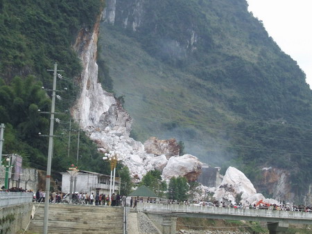
ChinaDaily is carrying the image below of an large rockfall in a former quarry in Fengshan County of Guangxi Province in China:

The accompanying report says that the landslide occurred without warning and without an obvious trigger in a long-abandoned quarry. The volume of the landslide is reported to be 21,000 cubic metres. It buried 300m of road, 16 buildings, two tractors, a car and a motorbike. Sadly, five people were killed, one person is reported missing and six people were injured, two seriously.
The accompanying report says that the landslide occurred without warning and without an obvious trigger in a long-abandoned quarry. The volume of the landslide is reported to be 21,000 cubic metres. It buried 300m of road, 16 buildings, two tractors, a car and a motorbike. Sadly, five people were killed, one person is reported missing and six people were injured, two seriously.
Thursday, November 20, 2008
Images of landslides from the Wenchuan Earthquake
(In response to requests, I have edited the post to provide some comments on the images)
I am in the middle of putting together a presentation on the impact of the Wenchuan Earthquake in China in May and thus have been looking for suitable materials. I stumbled across a fantastic Powerpoint presentation with images of the aftermath of the earthquake - this can be downloaded here.
There are a number of images of the landslides triggered by the earthquake in the presentation, but I thought would highlight three of them here:
 This image shows multiple shallow rock slides triggered by the earthquake. Note a few things here. First, a very large proportion (50%?) of the landscape has failed in this area. Second, the slides originate from very high on the slope - i.e. close to the ridge - and then extend all the way to the foot of the slope. This is characteristic of earthquake induced landslides and is associated with the high intensity of shaking that is experienced at the top of the slope. Finally, bite that piles of sediment at the toe of the slopes. This material will now move through the river system during periods of heavy rain and is likely to cause major problems downstream for years to come.

This picture shows a wider view of multiple shallow rock slope failures triggered by the earthquake. Most of the features pointed out above are again visible. The dust is caused by continuing landslide activity - probably in part due to aftershocks and in part with loosened material continuing to fail. The white area centre left appears to be zone of particularly shattered limestone. Note how the density of landslides reduces on the more gentle slopes in the background.
 This image shows the same features as above, but perhaps with the highest density of landslides. It does appear that there is a road or track at the bottom of the slope on the right. One can only imagine how difficult it will be to maintain these roads in the future.
Dave
I am in the middle of putting together a presentation on the impact of the Wenchuan Earthquake in China in May and thus have been looking for suitable materials. I stumbled across a fantastic Powerpoint presentation with images of the aftermath of the earthquake - this can be downloaded here.
There are a number of images of the landslides triggered by the earthquake in the presentation, but I thought would highlight three of them here:
 This image shows multiple shallow rock slides triggered by the earthquake. Note a few things here. First, a very large proportion (50%?) of the landscape has failed in this area. Second, the slides originate from very high on the slope - i.e. close to the ridge - and then extend all the way to the foot of the slope. This is characteristic of earthquake induced landslides and is associated with the high intensity of shaking that is experienced at the top of the slope. Finally, bite that piles of sediment at the toe of the slopes. This material will now move through the river system during periods of heavy rain and is likely to cause major problems downstream for years to come.
This picture shows a wider view of multiple shallow rock slope failures triggered by the earthquake. Most of the features pointed out above are again visible. The dust is caused by continuing landslide activity - probably in part due to aftershocks and in part with loosened material continuing to fail. The white area centre left appears to be zone of particularly shattered limestone. Note how the density of landslides reduces on the more gentle slopes in the background.
 This image shows the same features as above, but perhaps with the highest density of landslides. It does appear that there is a road or track at the bottom of the slope on the right. One can only imagine how difficult it will be to maintain these roads in the future.
Dave
Wednesday, November 19, 2008
Alesund landslide - the verdict
Back in April I posted extensively about a landslide that occurred in the town of Alesund in Norway. This slide occurred on 26th March, when a large block slipped into an apartment block, pushing it forward by up to seven metres and collapsing the lower floors. Five people were killed.

This week, the outcome of the commission of inquiry has been released. The key points are as follows:
 Presumably the blasting removed the toe of the block, destabilising it. If so then this looks to be an error of the site investigation and design. Given that the report has been handed over to Ministry of Justice, I would imagine that those involved in the original work will be somewhat uncomfortable now.

This week, the outcome of the commission of inquiry has been released. The key points are as follows:
- Blasting of the cliff during the construction of the apartment block was responsible for the failure;
- This blasting, which was intended to create the platform for the building, weakened the hillslope;
 Presumably the blasting removed the toe of the block, destabilising it. If so then this looks to be an error of the site investigation and design. Given that the report has been handed over to Ministry of Justice, I would imagine that those involved in the original work will be somewhat uncomfortable now.
Subscribe to:
Posts (Atom)