Alongside the continuing Attabad crisis, here is a summary of the last week in landslide events (in no particular order). The list is not exhaustive by any account, but these are the stories that caught my eye:
1.The Oliver debris flow in Canada
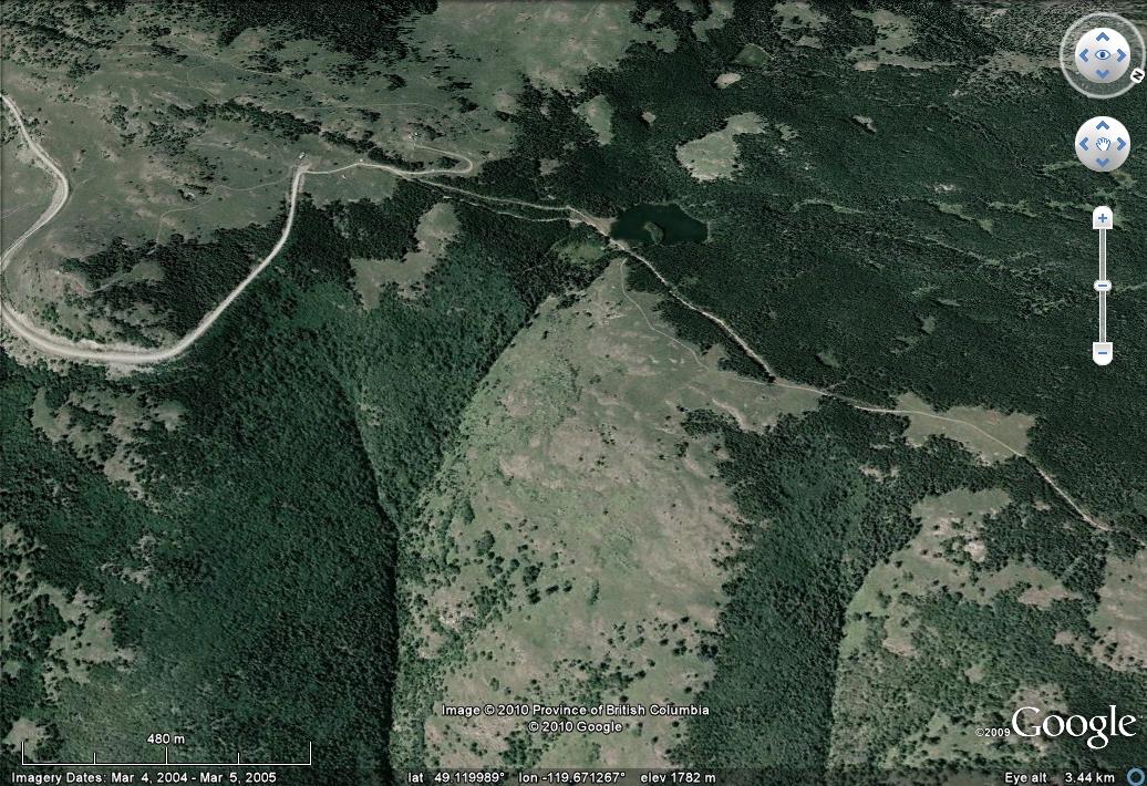
I covered this event in a post or two earlier in the week. It is now clear that the trigger was the overtopping and eventual failure (through a breach) of a small earthen dam high in the catchment (image from here):
The authorities were warned by a hiker that the lake was overtopping two days before the failure. It appears that there is now a great deal of soul searching occurring in Canada regarding the safety of these old and often poorly maintained structures.
2. A deadly landslide in Burma
No complaints please - I will not be drawn into using the other name for Burma imposed by the illegal and immoral junta that runs that country. Anyway, Bangladesh and Burma both suffered very heavy rainfall this week, triggering landslides across a wide area. In Burma a slide killed 56 people in Maungtaw and Buthidaung townships in Rakhine state, according to Xinhua.
3. Deadly landslides in Bangladesh
Meanwhile the same rainstorm caused chaos across a large part of the Cox's Bazaarand Bandarban areas of Bangladesh, with multiple landslides killing at least 55 people. As is so often the case, the blame is being laid at the door of deforestation and slope cutting.
4. Two slope accidents in China
China also suffered two terrible slope accidents this week. In the first, on Monday, 24 people were killed when a debris flow hit vehicles on a road in Nanping, in eastern Fujian Province. In the second, on Tuesday, a 40,000 cubic metre rockfall occurred at a hydroelectric project construction site in Pengta Town, Kangding County in Sichuan, killing 23 people. Meanwhile, as a I write, reports suggest that another slide in China today has killed up to five people in Taohua Village, Chun'an County in Zhejiang Province.
5. An interesting hit pit wall collapse in Australia
ABC News carries a story today about a large scale high pit wall collapse in the Savage River iron ore in Tasmania:
Note the excavator at the pit bottom for scale. The slide is reportedly 140,000 cubic metres in volume. There were no injuries or fatalities in this event.
6. Landslides in Darjeeling, India.
The ever-impressive Savethehills blog reports on landslides this week triggered by heavy rainfall in Darjeeling. One slide, in Tirpai, Kalimpong, killed three people. Readers may be interested in the dramatic video on this page, which shows a small landslide in action, with the unfortunate effect of the loss of a truck:
Friday, June 18, 2010
Thursday, June 17, 2010
Attabad - locals taking the situation into their own hands
Several media outlets in Pakistan are reporting that the level of frustration amongst the displaced people at Attabad has reached the point that they have taken the situation into their own hands. The Pamir Times has a pictorial record of what they have chosen to do - a large group have been working on the banks of the channel in an attempt to widen it. There is a full gallery of images here, from which these are taken:
Unfortunately, the amount that they can do in actually widening the channel is limited, whist the risks to those undertaking this work are high. Hacking away at the toe could destabilise the slope such that it collapses, dumping all of them in the water, and there is the potential for further slides from the slope behind.
Earlier reports suggested that people trying to join this effort from downstream has a confrontation with the police, and at least one person was injured.
I fear that this will ramp up the pressure on the authorities such that they will end up blasting the boulders without undertaking a full analysis. I hope that this does not happen - but that a proper study is undertaken urgently.
Unfortunately, the amount that they can do in actually widening the channel is limited, whist the risks to those undertaking this work are high. Hacking away at the toe could destabilise the slope such that it collapses, dumping all of them in the water, and there is the potential for further slides from the slope behind.
Earlier reports suggested that people trying to join this effort from downstream has a confrontation with the police, and at least one person was injured.
I fear that this will ramp up the pressure on the authorities such that they will end up blasting the boulders without undertaking a full analysis. I hope that this does not happen - but that a proper study is undertaken urgently.
Tuesday, June 15, 2010
Attabad - remarkable stability on the spillway - and some thoughts on what to do next
I will shortly post the latest update on the monitoring site, which shows that the lake level is continuing to rise at about 5 cm per day as inflow exceeds outflow. The spillway continues to show a remarkable level of stability. These two images compare an image from Sunday (left side) with one taken 24 hours later on Monday (right side). Whilst it is tempting to play spot the difference, the reality is almost no change:
So what to do now? Well, it is clear that there is a huge social cost to the current situation, which probably cannot continue for much longer. It is also surely clear that the current monitoring team cannot maintain the current level of activity for long given their living conditions. So here is my suggestion for a way forward. Please note this is not advice, and should not be treated as such, but rather it is a starting point for discussion.
1. NDMA sets up a detailed, integrated data collection system based upon, but enhancing, the current Focus activities. This should include the following measurements at 6 hour interval:, with the first measurement each day being taken at dawn
3. This is backed up with real time monitoring, preferably automatic, of inflow, landslide / rockfall activity at strategic points along the lake, and outflow, feeding a warning system. A command centre is established that would operate the alarm system should landslide flow rate increase. Boat crews and people in the red zone are trained as to what they should do if the alarm sounds.
4. The expert group meets at dusk each day to plan for the next day.
5. Alongside this a study is implemented immediately of management options for the spillway. This study should be undertaken properly, with international input, and will be made openly available when complete. A timetable is placed on the production of this report, and on the decisions that will be made on the basis of it.
6. All of this is backed up with a transparent communication strategy that explains the risks and benefits of the current situation, and of the various options.
This would seem to me to be the best balance between maintaining safety and allowing people to start to rebuild their lives. Of course this strategy will increase the risk that people face from the dam - but there are real risks associated with their displaced state too that we need to start to reduce. However, I must emphasise that to do this safely NDMA must use expert advice - this cannot be done any other way.
So what to do now? Well, it is clear that there is a huge social cost to the current situation, which probably cannot continue for much longer. It is also surely clear that the current monitoring team cannot maintain the current level of activity for long given their living conditions. So here is my suggestion for a way forward. Please note this is not advice, and should not be treated as such, but rather it is a starting point for discussion.
1. NDMA sets up a detailed, integrated data collection system based upon, but enhancing, the current Focus activities. This should include the following measurements at 6 hour interval:, with the first measurement each day being taken at dawn
- The flow rate in the spillway
- The seepage rate
- The lake level
- Landslide activity
- The inflow rate
- Temperature
- Seismic activity
3. This is backed up with real time monitoring, preferably automatic, of inflow, landslide / rockfall activity at strategic points along the lake, and outflow, feeding a warning system. A command centre is established that would operate the alarm system should landslide flow rate increase. Boat crews and people in the red zone are trained as to what they should do if the alarm sounds.
4. The expert group meets at dusk each day to plan for the next day.
5. Alongside this a study is implemented immediately of management options for the spillway. This study should be undertaken properly, with international input, and will be made openly available when complete. A timetable is placed on the production of this report, and on the decisions that will be made on the basis of it.
6. All of this is backed up with a transparent communication strategy that explains the risks and benefits of the current situation, and of the various options.
This would seem to me to be the best balance between maintaining safety and allowing people to start to rebuild their lives. Of course this strategy will increase the risk that people face from the dam - but there are real risks associated with their displaced state too that we need to start to reduce. However, I must emphasise that to do this safely NDMA must use expert advice - this cannot be done any other way.
Monday, June 14, 2010
The strange similarity between the Attabad and the landslide in Oliver
Yesterday I posted in both the ongoing situation at Attabad (and I am glad to say that it now seems likely that the reported landslide at Shimshal was a false alarm) and the mud and debris flow at Oliver in Canada. It is now reported that the Oliver slide was caused by the failure of an embankment retaining a small irrigation lake. If that is the case then I assume that the lake is this one:
The damage, shown below in an image from the Vancouver Sun, does serve to demonstrate the destructive potential of lake collapses, and thus our ongoing concerns about Attabad:
Has anyone seen any decent images of the path that the flow took between the lake and the valley floor?
The damage, shown below in an image from the Vancouver Sun, does serve to demonstrate the destructive potential of lake collapses, and thus our ongoing concerns about Attabad:
Has anyone seen any decent images of the path that the flow took between the lake and the valley floor?
Impressive mud and debris flow in Oliver, British Columbia
Thanks to a number of people for bringing this one to my attention. The community of Oliver in British Columbia yesterday suffered an impressive mud and debris flow that is reported to have destroyed five homes (images from the Vancouver Sun):
The flow has clearly come out of a deeply incised gully in the mountains:
A perspective view of the excellent Google Earth imagery of this area is rather helpful:
Two things to note here (the flow hit the area just above the "97" on the image above). First the community that has been hit by this flow is located on a small fan that has been formed by this type of flow. Second, the very narrow, deeply-incised channel mouth is the classic location for this type pf flow, where a blockage allows debris and water to accumulate, before collapsing to generate a flow. It is interesting to note that this area has reportedly experienced unusually heavy rainfall this spring and early summer.
The flow has clearly come out of a deeply incised gully in the mountains:
A perspective view of the excellent Google Earth imagery of this area is rather helpful:
Two things to note here (the flow hit the area just above the "97" on the image above). First the community that has been hit by this flow is located on a small fan that has been formed by this type of flow. Second, the very narrow, deeply-incised channel mouth is the classic location for this type pf flow, where a blockage allows debris and water to accumulate, before collapsing to generate a flow. It is interesting to note that this area has reportedly experienced unusually heavy rainfall this spring and early summer.
Sunday, June 13, 2010
Attabad - a further twist in the tail
Over the weekend the water level in the lake at Attabad has started to rise once again (see the monitoring site), presumably indicating that the warm weather in the Hunza region is increasing the rate of snowmelt, and therefore of inflow to the lake. The continued choke on flow being imposed by the large boulders in the channel is clear. The channel itself continues to evolve slowly through widening (image from Focus as per usual):
The amount of scour in the downstream portion of the channel is remarkably impressive:
It would appear that development of the the channel continues to be impeded by a small number of critical boulders, one of which may well be below the water level, protecting the stream bed against downcutting. The Pamir Times images of the site, available in this gallery, are quite instructive. This composite image in particular is interesting, clearly showing how the boulders are controlling the discharge:
Meanwhile, landslides continue to occur with a high frequency in the Attabad area (Focus image):
The amount of scour in the downstream portion of the channel is remarkably impressive:
It would appear that development of the the channel continues to be impeded by a small number of critical boulders, one of which may well be below the water level, protecting the stream bed against downcutting. The Pamir Times images of the site, available in this gallery, are quite instructive. This composite image in particular is interesting, clearly showing how the boulders are controlling the discharge:
Meanwhile, landslides continue to occur with a high frequency in the Attabad area (Focus image):
Friday, June 11, 2010
Two very interesting galleries of recent landslides
I am now trying to catch up on everything that has been pushed aside by the Attabad landslide saga. Whilst all of this has been going on there have been a number of other substantial landslide events. Two of these have impressive galleries of images available, both of which are worth a look:
1. Tropical Cyclone Agatha in Guatemala
The landfall of Tropical Cyclone Agatha on 29th May triggered extensive landslides over a wide area in that country, killing over 150 people. One of the affected areas was the town of San Antonio Palopo. A group of the expatriates have set up a website appealing for assistance (I have no idea as to the legitimacy of this appeal, but also have no reason to disbelieve them). They have put a gallery of images online here. An example of the images is this:
2. Lanckorona, Poland
Meanwhile, the town of Lanckorona in Poland is being slowly destroyed by a large, slow moving landslide, with terrible consequences for the inhabitants. At the time of writing, a second phase of movements has been reported. There is a couple of decent videos of the town here, but most impressive (and dreadful) is the extensive gallery of images here, including these two:
Both sets of images are worth a look
1. Tropical Cyclone Agatha in Guatemala
The landfall of Tropical Cyclone Agatha on 29th May triggered extensive landslides over a wide area in that country, killing over 150 people. One of the affected areas was the town of San Antonio Palopo. A group of the expatriates have set up a website appealing for assistance (I have no idea as to the legitimacy of this appeal, but also have no reason to disbelieve them). They have put a gallery of images online here. An example of the images is this:
2. Lanckorona, Poland
Meanwhile, the town of Lanckorona in Poland is being slowly destroyed by a large, slow moving landslide, with terrible consequences for the inhabitants. At the time of writing, a second phase of movements has been reported. There is a couple of decent videos of the town here, but most impressive (and dreadful) is the extensive gallery of images here, including these two:
Both sets of images are worth a look
Subscribe to:
Posts (Atom)