(In response to requests, I have edited the post to provide some comments on the images)I am in the middle of putting together a presentation on the impact of the
Wenchuan Earthquake in China in May and thus have been looking for suitable materials. I stumbled across a fantastic
Powerpoint presentation with images of the aftermath of the earthquake - this can be downloaded
here.
There are a number of images of the landslides triggered by the earthquake in the presentation, but I thought would highlight three of them here:

This image shows multiple shallow
rock slides triggered by the earthquake. Note a few things here. First, a very large proportion (50%?) of the landscape has failed in this area. Second, the slides originate from very high on the slope - i.e. close to the ridge - and then extend all the way to the foot of the slope. This is characteristic of earthquake induced landslides and is associated with the high intensity of shaking that is experienced at the top of the slope. Finally, bite that piles of sediment at the toe of the slopes. This material will now move through the river system during periods of heavy rain and is likely to cause major problems downstream for years to come.

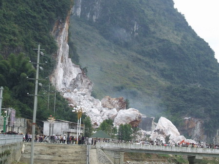
This picture shows a wider view of multiple shallow
rock slope failures triggered by the earthquake. Most of the features pointed out above are again visible. The dust is caused by
continuing landslide activity - probably in part due to aftershocks and in part with loosened material continuing to fail. The white area centre left appears to be zone of
particularly shattered limestone. Note how the density of landslides reduces on the more gentle slopes in the background.

This image shows the same features as above, but perhaps with the highest density of landslides. It does appear that there is a road or track at the bottom of the slope on the right. One can only imagine how difficult it will be to maintain these roads in the future.
Dave